Collaborative visualization and modeling system and method for multi-source multi-parameter gravity and magnetic data

A multi-parameter, data technology, applied in 3D modeling, visual data mining, image data processing, etc., can solve the problem of lack of 3D scene control and interpretation data interaction, lack of consideration of geophysical factors, lack of multi-source and multi-type data Unified management, method and technology matching and other issues, to achieve the effect of strong flexibility, good connection and correlation

Active Publication Date: 2021-10-08
JILIN UNIV
View PDF9 Cites 0 Cited by
  • Summary
  • Abstract
  • Description
  • Claims
  • Application Information

AI Technical Summary

Problems solved by technology

[0005] 1. In terms of 3D visualization expression, there is a lack of perfect 3D modeling and scene control, rich model information extraction and model integration capabilities;
[0006] 2. The geophysical influence factors are not considered in the process of establishing the geological model. Most of them are two-dimensional profile data human-computer interaction modeling schemes, which integrate three-dimensional geological elements such as faults, layers, geological bodies and geophysical elements. Borehole data, seismic data, and physical property data , Collaborative modeling and visualization methods for geophysical interpretation data are rare;
[0007] 3. Existing open source systems lack unified management of multi-source and multi-type data and method and technology support, lack of relatively complete 3D scene control and interpretation data interaction; most do not support collaborative visualization of 2D and 3D observation and interpretation data, and the response speed is slow Slow, making it inconvenient for interpreters to use

Method used


Image

  • Collaborative visualization and modeling system and method for multi-source multi-parameter gravity and magnetic data
  • Collaborative visualization and modeling system and method for multi-source multi-parameter gravity and magnetic data
  • Collaborative visualization and modeling system and method for multi-source multi-parameter gravity and magnetic data

Examples


Embodiment 1

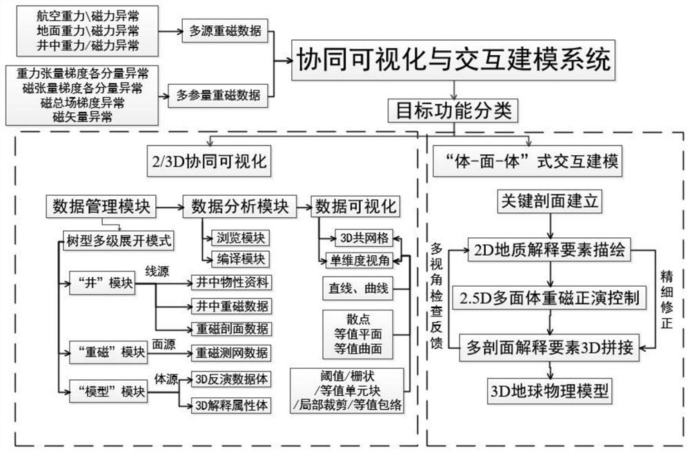
[0036] Embodiment 1, specifically as figure 1 As shown, a collaborative visualization and modeling system for multi-source multi-parameter gravity and magnetic data is provided, including a 2 / 3D collaborative visualization module and a body-surface-body interactive modeling module;

[0037] Wherein, the 2 / 3D collaborative visualization module includes a data management module, a data analysis module and a data visualization module, and the data management module completes the management of line source, area source, and volume source data through a tree-type multi-level expansion mode,

[0038] The line source is specifically the physical property material in the well 9, the gravity and magnetic data in the well and the gravity and magnetic profile data, the area source is specifically the gravity and magnetic survey network data, and the volume source is specifically the 3D inversion data volume and the 3D interpretation attribute volume .

[0039] The data analysis module is...

experiment example

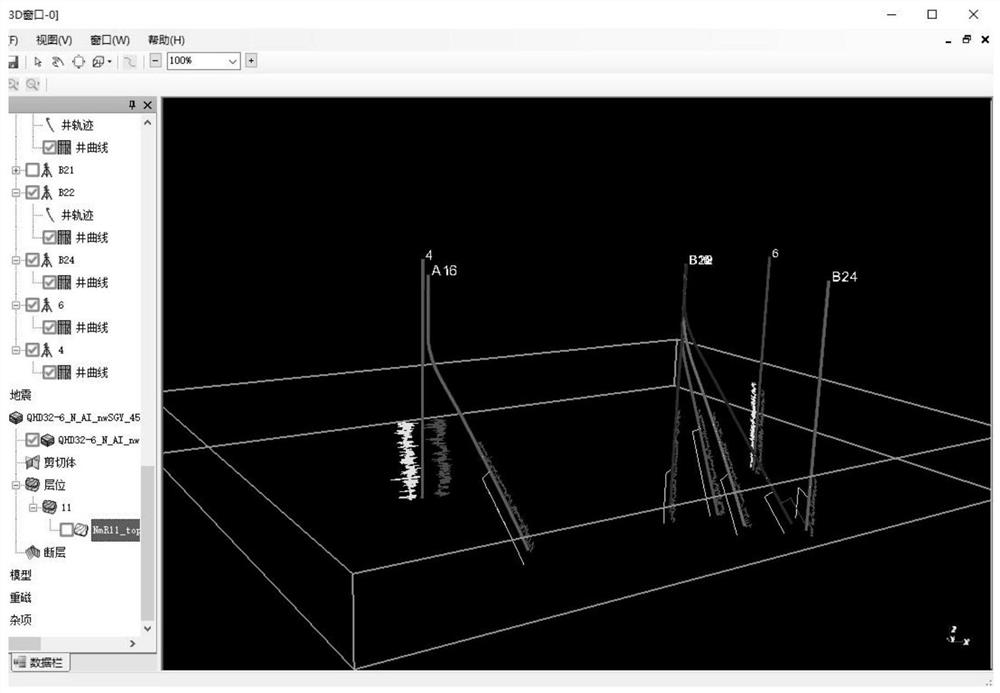
[0056] Experimental example, using multi-source gravity and magnetic data in a thick coverage area in Shandong, ground gravity, aeromagnetic data, and 3D attribute volume obtained from 3D data inversion, for collaborative visualization and interactive modeling, as follows Image 6 shown;

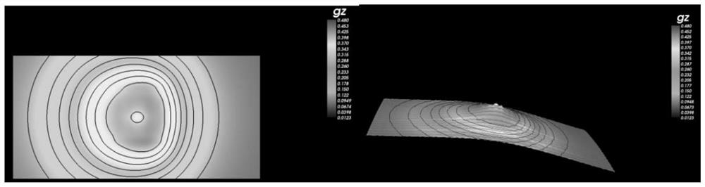
[0057] In order to endow modeling with meaning for geophysical data interpretation, information features are extracted from physical property inversion results according to interpretation requirements, and regional fault and geological body models are established relying on the distribution characteristics of gravity and magnetic inversion interpretation results. The visualization and modeling methods and systems can Well-solved multi-element geoscience feature-rich interpretation of multi-source gravity and magnetic data, specifically as Figure 7 shown;

[0058] It can be seen that the model in this example can meet the basic needs of interpreters and provide a favorable reference for oth...


PUM


Abstract

The invention discloses a collaborative visualization and modeling system and method for multi-source multi-parameter gravity and magnetic data, and the system comprises a 2/3D collaborative visualization module and a body-surface-body type interactive modeling module, and the 2/3D collaborative visualization module comprises a data management module, a data analysis module and a data visualization module. The body-plane-body type interactive modeling module is composed of a key section establishment module, a 2D geological interpretation element description module, a 2.5 D polyhedron gravity and magnetic forward modeling control module and a multi-section interpretation element 3D splicing module, and is autonomously established based on a C # and VTK visualization toolkit in a Windows environment. In the modeling process, geological interpretation element faults, horizon and geologic bodies are autonomously formed by a user according to a three-dimensional gravity and magnetic data quantitative physical property inversion result, good connection and association with the geophysical interpretation process are embodied, the flexibility is high, multi-source multi-parameter gravity and magnetic observation data can be fused, and three-dimensional geophysical model establishment is achieved.

Description

technical field [0001] The invention belongs to the technical field of collaborative visualization and modeling based on multi-source multi-parameter gravity and magnetic data of geophysics, and in particular relates to a collaborative visualization and modeling system and method for multi-source multi-parameter gravity and magnetic data. Background technique [0002] For a long time, gravity and magnetic method interpreters are more inclined to the interpretation process of human-computer interaction. Interpreters often use simple and regular shapes to simulate complex geological bodies. Among them, the human-computer interaction modeling and interpretation method and system of gravity and magnetic anomalies in section (2D) are more suitable. Sophisticated and common. In the process of 3D gravity and magnetic interpretation, it is necessary to continuously edit and modify the geological body model, so the interactive modeling method becomes the key issue of the system. In ...

Claims


Application Information

Patent Timeline
Patent Type & Authority Applications(China)
IPC IPC(8): G06T17/05G06T17/20G06T11/20G06F30/23G06F16/26
CPCG06T17/05G06T17/20G06T11/206G06F30/23G06F16/26
Inventor 王泰涵李宗睿李丽丽马国庆
Owner JILIN UNIV
Why Eureka
Try Eureka