Airline path updating method and system, and storage medium

A path update and route technology, applied in the field of detection, can solve problems such as difficult ship trajectories and effective monitoring, and achieve the effects of good real-time performance, high accuracy, and improved rationality and accuracy.

Active Publication Date: 2021-10-15
ZHEJIANG TEQIN SATELLITE NAVIGATION TECH CO LTD
View PDF7 Cites 0 Cited by
  • Summary
  • Abstract
  • Description
  • Claims
  • Application Information

AI Technical Summary

Problems solved by technology

[0003] In order to solve the technical problem existing in the prior art that it is difficult to quickly and effectively monitor t...

Method used


Image

  • Airline path updating method and system, and storage medium
  • Airline path updating method and system, and storage medium
  • Airline path updating method and system, and storage medium

Examples


Embodiment 1

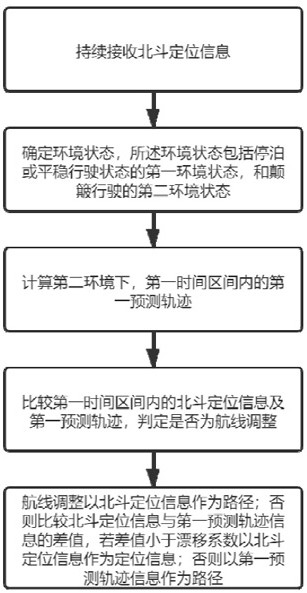
[0044] This embodiment provides a method for updating an airline path, such as Figure 1-3 shown, including:

[0045] S1 uses a high-precision Beidou positioning device to continuously receive Beidou positioning information. Determine the time period, and the Beidou positioning information corresponding to each moment in each time period. For safety considerations and policy requirements, usually there are at least two high-precision Beidou positioning devices, one head and one tail installed inside the hull of the ship.

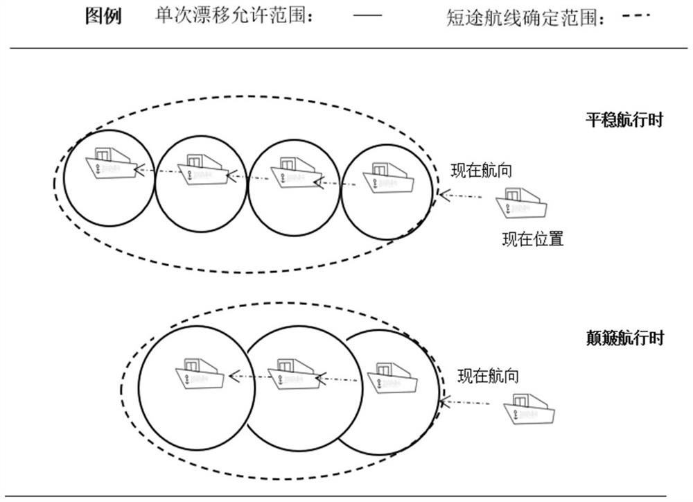
[0046] S2 determines the environmental state, which includes a first environmental state of parking or a smooth driving state, and a second environmental state of a bumpy driving state.

[0047] S3 calculates the first predicted trajectory in the first time interval. Predicted trajectory is calculated based on channel information, current location point information, speed, and sampling time. The calculation method of the trajectory is to predict the next...

Embodiment 2

[0067] The present embodiment provides a flight route update system, including: a sensor system, a shipboard system, and a shore-based management and control background. The sensing system includes: a high-precision Beidou positioning device, which is responsible for obtaining Beidou positioning signals. The shipborne system includes: a time threshold determination module, a path information update module, and a calculation parameter adjustment module, which are responsible for processing the Beidou positioning information, calculating the drift of the Beidou positioning information, performing positioning prediction and correction calculations, judging the abnormal information of the Beidou positioning information drift, and reporting Beidou positioning information and Beidou positioning information drift abnormal information, receiving positioning information correction parameters sent by the Beidou signal drift filtering big data calculation server. The shore-based manageme...


PUM


Abstract

The invention provides a route path updating method. The route path updating method comprises the following steps of S1, continuously receiving the Beidou positioning information; S2, determining an environment state; S3, calculating a first prediction trajectory in a first time interval; S4, comparing the Beidou positioning information in the first time interval with the first prediction trajectory, and judging whether the course adjustment is performed or not; and S5, if the route adjustment is determined, taking the Beidou positioning information as the path information in a first time interval; otherwise, comparing the difference value between the Beidou positioning information at each moment and the first predicted trajectory information, and if the difference value between the Beidou positioning information at the moment and the first predicted positioning information is smaller than the drift coefficient, taking the Beidou positioning information as the positioning information at the moment; and otherwise, taking the first predicted trajectory information at the moment as the path information at the moment. According to the method, technical problems of poor continuity and low real-time performance of existing path updating communication are solved, and accurate monitoring of the ship route path is realized.

Description

technical field [0001] The invention relates to the detection field, in particular to a method for updating an airline route. Background technique [0002] At present, the Beidou high-precision positioning device is one of the more effective methods for ship path monitoring. However, due to the complex water surface environment and the need for short-term adjustment of the path during the ship's travel, there are differences between the Beidou positioning signal and the expected path. In particular, conditions such as speed and turbulence have a greater impact on the accuracy of Beidou positioning signals. Therefore, there are differences between path monitoring on rivers or oceans and path monitoring on the ground in a static state. Conventional path monitoring methods on the ground cannot effectively deal with complex environments on rivers or oceans, and cannot quickly and accurately judge positioning changes. Then it is impossible to effectively monitor the travel path...

Claims


Application Information

Patent Timeline
IPC IPC(8): G01S19/42G01C21/20
CPCG01S19/42G01C21/203
Inventor 徐涛陈斐斐俞敏华
Owner ZHEJIANG TEQIN SATELLITE NAVIGATION TECH CO LTD
Why Eureka
Try Eureka