Color equalization method of coastal area based on ocean vector file and image channel threshold

A vector file and image technology, which is applied in the field of color uniformity in coastal areas, can solve the problems of limited usage scenarios, time-consuming and labor-intensive, low recognition rate, etc., to achieve the effect of facilitating parallel computing, improving accuracy, and solving low recognition rate

Active Publication Date: 2022-06-07
江苏天汇空间信息研究院有限公司
View PDF5 Cites 0 Cited by
  • Summary
  • Abstract
  • Description
  • Claims
  • Application Information

AI Technical Summary

Problems solved by technology

[0005] At the same time, the threshold method and the sea-land boundary detection method all have low recognition rates. It is extremely time-consuming and manpower-intensive to use manual image processing for coastal areas, and for ocean recognition in coastal areas based on neural networks. A large amount of training data is required, and this part of the training data requires a lot of manpower to label, which is very time-consuming, and requires a lot of manpower and material resources to have training data, while training the model on the training data requires a lot of computing resources, and the effect will be the same as The training data is strongly correlated, and the universality is poor
And assuming that after the model training is completed, the recognition of the image needs to be calculated by the neural network, which leads to the recognition will be very slow, and the usage scenarios are limited.

Method used


Image

  • Color equalization method of coastal area based on ocean vector file and image channel threshold
  • Color equalization method of coastal area based on ocean vector file and image channel threshold
  • Color equalization method of coastal area based on ocean vector file and image channel threshold

Examples


Embodiment Construction

[0067] The technical solutions in the embodiments of the present invention will be clearly and completely described below with reference to the accompanying drawings in the embodiments of the present invention. Obviously, the described embodiments are only a part of the embodiments of the present invention, but not all of the embodiments. Based on the embodiments of the present invention, all other embodiments obtained by those of ordinary skill in the art without creative efforts shall fall within the protection scope of the present invention.

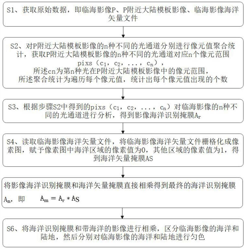
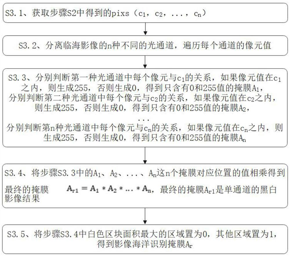
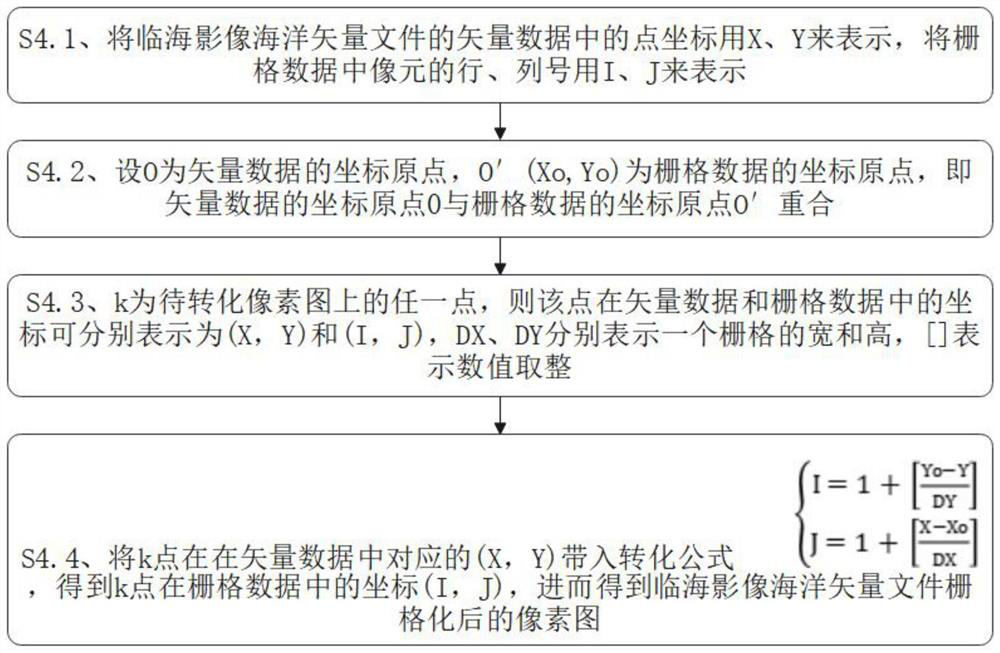
[0068] see Figure 1-3 , the present invention provides a technical solution: a method for leveling the color of a coastal area based on a marine vector file and an image channel threshold, the method includes the following steps:

[0069] S1. Obtain the original data, namely the coastal image P, the template image of the continent near P, and the marine vector file of the coastal image;

[0070] S2. Perform pixel value aggregation s...


PUM


Abstract

The present invention discloses a method for color uniformity in the seaside area based on ocean vector files and image channel thresholds. S2. Perform pixel value aggregation and statistics on n different optical channels of the continental template image near P to obtain the continental template image near P. The n different optical channels correspond to n pixel range pixs(c 1 , c 2 ,...,c n ). The invention not only combines the vector file of geographic information (GIS) and the raster file of remote sensing (RS) image, breaks the barriers of subdivided industries, and solves the problem of low recognition rate of a single method and time-consuming and labor-intensive problems. The accuracy rate of land and sea recognition is improved, and the dynamic threshold method is adopted to improve the recognition rate of the traditional fixed threshold method. Post-processing by hand.

Description

technical field [0001] The invention relates to the technical field of remote sensing image processing, in particular to a seaside area color equalization method based on an ocean vector file and an image channel threshold. Background technique [0002] In the current technology for leveling seaside images, the main purpose of the design of the land optical satellite is to shoot land images, and the seawater is very different from the land resources due to various physical and chemical characteristics, resulting in the seawater captured by the land optical satellite. The image will be quite different from the terrestrial image (including inland rivers and lakes) in various parameters; [0003] Ocean vector map is a method of marking conventional ocean boundary conditions, which is related to the time and scale of the background data referenced when the vector map itself is made. There are differences in the reference backgrounds of the vector graphics at that time, and dire...

Claims


Application Information

Patent Timeline
Patent Type & Authority Patents(China)
IPC IPC(8): G06T11/00G06T11/20G06V20/13G06T7/90
CPCG06T11/001G06T11/206G06T7/90G06T2207/10032G06T2207/30184Y02A90/10
Inventor 张业红顾行发黄祥志许王疆
Owner 江苏天汇空间信息研究院有限公司
Why Eureka
Try Eureka