Combined high-altitude wind detection method

A detection method and high-altitude wind technology, applied in measurement devices, radio wave measurement systems, instruments, etc., can solve the problems of low wind measurement accuracy, reduced wind measurement accuracy, and low INS positioning accuracy, and achieve high wind measurement accuracy. Effect

Pending Publication Date: 2021-11-19
NAT UNIV OF DEFENSE TECH
View PDF1 Cites 1 Cited by
  • Summary
  • Abstract
  • Description
  • Claims
  • Application Information

AI Technical Summary

Problems solved by technology

INS wind measurement is independent and reliable, but the current INS positioning accuracy is lower than GNSS, resulting in low wind measurement accu

Method used


Image

  • Combined high-altitude wind detection method
  • Combined high-altitude wind detection method

Examples


Embodiment Construction

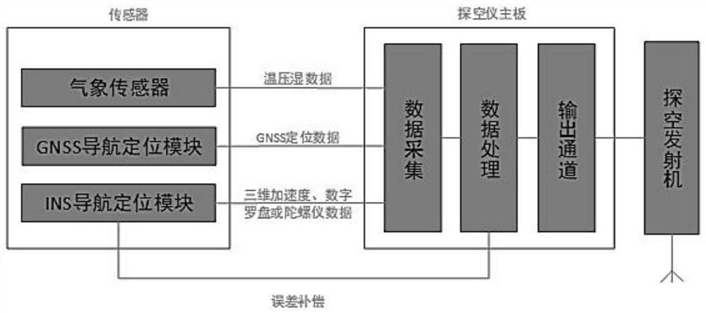
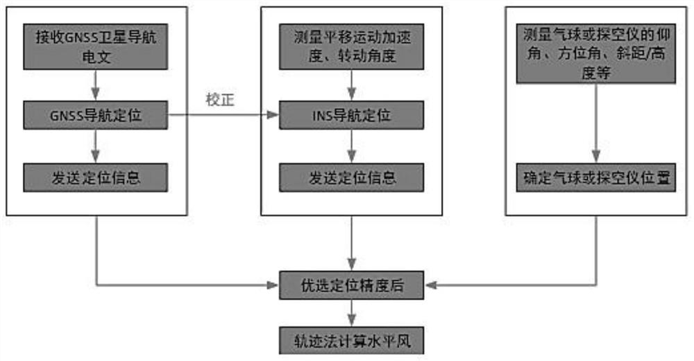
[0017] Before the combined radiosonde is launched, the INS navigation and positioning module needs to be initially aligned. The purpose is to establish the initial relationship between the radiosonde coordinate system and the geographic coordinate system, and provide an initial value for the integral. Since the radiosonde is single-use, a low-cost initial alignment algorithm will be used. The specific process is as follows. First, read the acceleration information collected by the inertial navigation module under the condition of static ground, compare it with the local gravity acceleration, use the attitude transformation matrix to reverse the attitude angle information, and input the initial value of the attitude angle into the data The processing module serves as the initial attitude matrix, thus, the initial alignment of the INS radiosonde is completed.

[0018] Since the INS navigation and positioning module uses the integral solution to combine the position information o...


PUM


Abstract

The invention relates to a combined high-altitude wind detection method. According to the method, positioning data is selected through a GNSS (Global Navigation Satellite System), the position of a sonde is acquired in real time, high-altitude wind speed measurement, wind direction and wind profile calculation and measurement data processing are conducted on the continuously measured position, and calculating is conducted to obtain high-altitude wind by utilizing a trajectory method; a GNSS navigation positioning module adopts a multi-mode navigation positioning mode, receives a navigation signal sent by a Beidou system, and outputs GNSS positioning data after optimization processing; the navigation parameters and sounding measurement information are transmitted to a sonde mainboard, the sonde mainboard completes data quality processing, signal sampling transformation and data stream generation of meteorological element values and sonde positioning data information through an input module and a gain amplification module, parameters such as a speedometer in an INS navigation positioning module are processed before and after a GNSS, the INS navigation parameters in the missing measurement time period are corrected, and positioning data in the GNSS missing measurement time period is output after processing.

Description

Technical field: [0001] The invention is a ball-borne high-altitude wind detection technology combining GNSS (Global Navigation Satellite System, the most mature ones are GPS and Beidou) and INS (Inertial Navigation System, inertial navigation system), mainly used in The field of high-altitude meteorological detection. Background technique: [0002] Upper-altitude wind detection in meteorological operations generally refers to the determination of the direction and speed of horizontal airflow at various heights from the ground to more than 30 kilometers in the air, that is, the determination of wind direction and wind speed. Real-time and accurate high-altitude wind detection data are the most basic data for weather analysis and forecasting, and are also the basic data for military meteorological support such as airdrops and airborne, artillery and air defense ballistic corrections. In meteorological operations, objects floating with the airflow (usually a weather balloon o...

Claims


Application Information

Patent Timeline
IPC IPC(8): G01W1/08G01W1/02G01S19/47
CPCG01W1/08G01W1/02G01S19/47Y02A90/10
Inventor 赵世军单雨龙赵文凯孙科蕾
Owner NAT UNIV OF DEFENSE TECH
Why Eureka
Try Eureka