
Ship route planning management method

A management method and route technology, applied in the field of ship routes, can solve problems such as poor robustness, little consideration of meteorological conditions, increased emissions, etc., to achieve the effect of improving safety

Pending Publication Date: 2021-11-19
黑龙江万佳诚科技有限公司
View PDF0 Cites 1 Cited by
  • Summary
  • Abstract
  • Description
  • Claims
  • Application Information

AI Technical Summary

Problems solved by technology

[0002] In recent years, with the rapid development of the economy, the number of ships in the world is gradually increasing. Due to the influence of sea routes, ships are becoming more and more crowded. Therefore, route planning and design have become an indispensable and important link. Route design and Optimization is a complex decision-making process. It is to fully consider environmental factors, ship performance, cargo factors, port factors, etc. under the premise of ensuring the safety of the ship and the people on board, so that the ship can achieve the best economy and comfort when sailing. Including the shortest voyage distance, the lowest fuel consumption, the lowest voyage time, the lowest ship damage and cargo damage, etc., so as to achieve the goal of reducing operating costs and greatly improving transportation efficiency. Therefore, this is a typical multi-objective optimization problem. Traditional route optimization The disadvantages of the algorithm are that sufficient prior knowledge is required, and it is difficult to deal with target noise, the robustness is poor, the efficiency of optimization is not high, and the dynamically changing meteorological conditions are rarely considered, which makes the ship prone to encounter harsh weather conditions during navigation. Meteorological conditions, even catastrophic sea conditions such as typhoons and huge waves, greatly threaten the navigation safety of ships. The economic benefits will decrease; bad weather will also lead to an increase in fuel consumption and emissions, and aggravate the pollution of the marine environment

Method used


Image

  • Ship route planning management method

Examples


Embodiment Construction

[0013] In order to make the objects and advantages of the present invention clearer, the present invention will be further described below in conjunction with the examples; it should be understood that the specific examples described here are only for explaining the present invention, and are not intended to limit the present invention.

[0014] Preferred embodiments of the present invention are described below with reference to the accompanying drawings. Those skilled in the art should understand that these embodiments are only used to explain the technical principle of the present invention, and are not intended to limit the protection scope of the present invention.

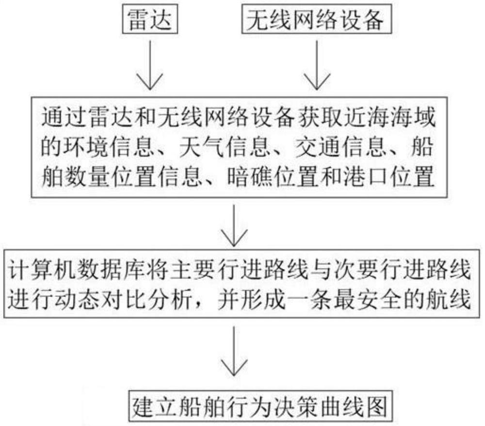
[0015] The invention relates to a method for planning and managing a shipping route, comprising:

[0016] 1): Real-time data collection, collecting and obtaining weather and traffic information in the nearby sea area according to the actual needs of users, and synchronizing the obtained information to the back...


PUM


Abstract

The invention relates to a ship route planning management method. The method is characterized by comprising the following steps of: 1) acquiring real-time data, acquiring weather and traffic information of a nearby sea area according to the actual demand of a user, and synchronizing the acquired information into a background information base; 2) fixed information acquisition: acquiring information of a port and an obstacle area in a specified target sea area according to radar, and synchronizing the acquired information to a background information base. According to the scheme provided by the invention, through the radar, wireless communication equipment and the background information base, information required by ship route planning can be collected, processed and analyzed, so that a ship route can be planned according to all the information after integration and analysis in the advancing process of a ship, the problem that the ship is easily affected by various factors in the advancing process due to the fact that a traditional ship does not have safe and intelligent route planning can be effectively solved, it is ensured that the ship can sail according to the safe route, and the safety of the ship in the sailing process is improved.

Description

technical field [0001] The invention relates to the technical field of ship routes, in particular to a method for planning and managing ship routes. Background technique [0002] In recent years, with the rapid development of the economy, the number of ships in the world is gradually increasing. Due to the influence of sea routes, ships are becoming more and more crowded. Therefore, route planning and design have become an indispensable and important link. Route design and Optimization is a complex decision-making process. It is to fully consider environmental factors, ship performance, cargo factors, port factors, etc. under the premise of ensuring the safety of the ship and the people on board, so that the ship can achieve the best economy and comfort when sailing. Including the shortest voyage distance, the lowest fuel consumption, the lowest voyage time, the lowest ship damage and cargo damage, etc., so as to achieve the goal of reducing operating costs and greatly impro...

Claims


Application Information

Patent Timeline
IPC IPC(8): G06Q10/04G06Q50/30
CPCG06Q10/047G06Q50/40
Inventor 李珊珊
Owner 黑龙江万佳诚科技有限公司
Learn More