Automatic shortest route planning method based on AIS data

A technology for automatic planning and routing, applied in navigation, surveying and mapping and navigation, navigation calculation tools, etc., can solve the problems of large economic and time costs, and many navigational constraints

Pending Publication Date: 2020-11-13
SHANGHAI SHIP & SHIPPING RES INST
View PDF0 Cites 5 Cited by
  • Summary
  • Abstract
  • Description
  • Claims
  • Application Information

AI Technical Summary

Problems solved by technology

[0005] 1. The existing automatic route planning algorithm needs to rely on a large amount of chart data, and updating these chart data dynamically requires a lot of economic and time costs;
[0006] 2. The above route planning algorithm needs to consider many navigation constraints, and needs to fully study the complex navigation environment;
[0007] 3. In addition, most route planning algorithms can only calculate locally optimal routes

Method used


Image

  • Automatic shortest route planning method based on AIS data
  • Automatic shortest route planning method based on AIS data
  • Automatic shortest route planning method based on AIS data

Examples


Embodiment Construction

[0057] Below in conjunction with accompanying drawing, the present invention is described in further detail, so that those skilled in the art understand:

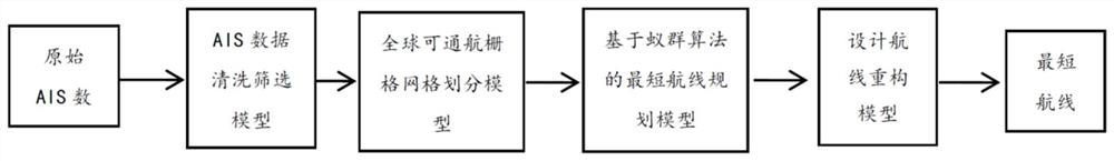
[0058] see figure 1As shown, the embodiment of the present invention provides a method for automatic planning of the shortest route based on AIS data. Navigable Points, a matrix value that determines the global grid network, defines navigable rasters. Using the adjacency matrix combined with the global longitude and latitude distance formula, the distance calculation is performed on each navigable grid. Based on the ant colony algorithm and the calculated adjacency matrix, find the optimal distance from the starting point to the end point, and output the planned route. Since the route planned for the first time is obtained based on the grid network, and the output route has many turning points, it is necessary to re-plan the design route in line with the actual habits according to the crew's habit of planning routes. The...


PUM


Abstract

The invention discloses an automatic shortest route planning method based on AIS data. The automatic shortest route planning method comprises the following steps: A, dividing global longitude and latitude into a two-bit grid matrix; judging whether AIS data appears in each grid or not, if the AIS data appears, determining the grid as a navigable grid, and determining the distance between all adjacent navigable grids; B, converting the longitude and latitude of a given starting point and a given arrival point into corresponding grid position coordinates in a two-bit grid matrix; and C, performing cyclic search in the two-bit grid matrix through an ant colony algorithm so as to output a shortest route from a starting point to an arrival point. The method has the advantages that the collectedAIS data is screened under the condition that a large number of electronic nautical charts are not used such that an airline meeting the actual application requirements is constructed; ship navigation conditions under complex navigation factors are fully studied by utilizing AIS data updated in real time such that safe navigation of a target ship is ensured; and a shortest route for avoiding falling into local optimum is obtained by using an ant colony algorithm.

Description

technical field [0001] The invention relates to the technical field of ship route speed optimization, in particular to an automatic planning method of the shortest route based on AIS data. Background technique [0002] With the rapid development of shipping, the crew needs to do more navigation work before sailing to cope with the changing sailing environment at sea. Automatically planning the route according to the given starting point and destination can reduce the workload of the crew and improve the work before sailing. efficiency. In addition, the route planning algorithm aimed at the shortest route can help the crew find the shortest route, thereby reducing fuel consumption costs during voyages and improving the operating efficiency of shipping companies. In recent years, with the rapid development of computer networks and control theory, more and more shipping companies have begun to pay attention to hot issues such as unmanned ships, and the realization of automatic...

Claims


Application Information

Patent Timeline
Patent Type & Authority Applications(China)
IPC IPC(8): G01C21/20
CPCG01C21/203
Inventor 乔继潘季盛张焱飞文逸彦
Owner SHANGHAI SHIP & SHIPPING RES INST
Why Eureka
Try Eureka