Airborne downscaling method for constructing vegetation coverage through multi-source data fusion

A technology of vegetation coverage and multi-source data, applied in the field of multi-source data fusion to construct vegetation coverage time-space drop scale, which can solve the problem of image downscaling accuracy loss and other issues

Pending Publication Date: 2021-12-07
甘肃中星鸿图科技有限公司
View PDF0 Cites 2 Cited by
  • Summary
  • Abstract
  • Description
  • Claims
  • Application Information

AI Technical Summary

Problems solved by technology

[0004] The purpose of the present invention is to address the above-mentioned deficiencies in the prior art, and to provide a multi-source data fusion method for const

Method used


Image

  • Airborne downscaling method for constructing vegetation coverage through multi-source data fusion
  • Airborne downscaling method for constructing vegetation coverage through multi-source data fusion
  • Airborne downscaling method for constructing vegetation coverage through multi-source data fusion

Examples


Embodiment Construction

[0034] The specific embodiments of the present invention are described below so that those skilled in the art can understand the present invention, but it should be clear that the present invention is not limited to the scope of the specific embodiments. For those of ordinary skill in the art, as long as various changes Within the spirit and scope of the present invention defined and determined by the appended claims, these changes are obvious, and all inventions and creations using the concept of the present invention are included in the protection list.

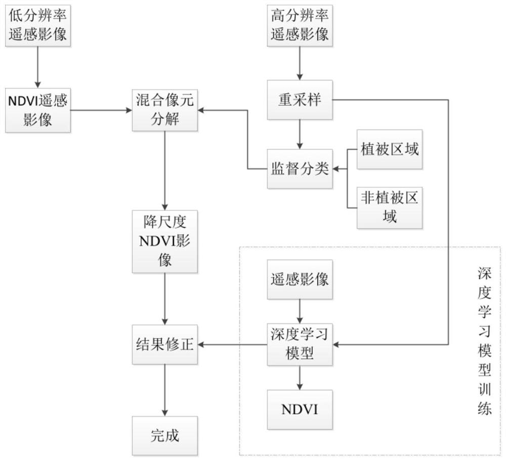
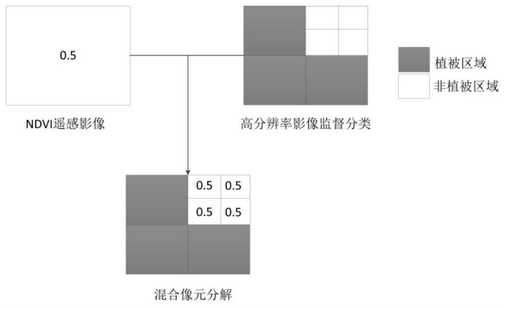
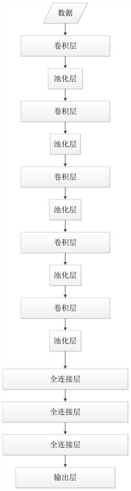
[0035] According to an embodiment of the present application, refer to figure 1 , the multi-source data fusion of this program constructs the time-space drop scale method of vegetation coverage, including the following steps:

[0036] S1. Find and download the NDVI product from the MODIS official website, and obtain the Gaofen No. 1 data in the NDVI product.

[0037] S2. Resampling high-resolution images and implementing s...


PUM


Abstract

The invention discloses an airborne downscaling method for constructing vegetation coverage through multi-source data fusion. The airborne downscaling method comprises the following steps: s1, acquiring high-score 1 data in an NDVI product; s2, supervising and classifying down-sampled high-score No.1 data, and dividing the down-sampled high-score No.1 data into a vegetation region and a non-vegetation region; s3, filling the vegetation area with NDVI values while the non-vegetation area is not filled with data; s4, training the high-score No.1 image sample by adopting deep learning to obtain data for accurately identifying the NDVI model; s5, based on an NDVI model, carrying out NDVI image extraction on the downsampled Gaofen-1 data, and correcting a numerical value in the downscaled NDVI image data. The method plays an important role in monitoring vegetation coverage change, crop growth condition, ground feature type identification, crop yield estimation, biomass estimation, surface evapotranspiration, soil humidity monitoring, climate change and the like in the NDVI image data with high temporal-spatial resolution.

Description

technical field [0001] The invention belongs to the technical field of vegetation coverage downscaling, and in particular relates to a time-space downscaling method for constructing vegetation coverage by fusion of multi-source data. Background technique [0002] In order to study the vegetation NDVI down-sampling technology, Jia Yanyan proposed to down-sample the low-resolution vegetation index NDVI image, and use the down-sampled image to perform model fitting with the high-resolution vegetation index NDVI image, in order to build a high spatial resolution NDVI Imaging provides an effective method. Chen Jin proposed a method based on the MODIS pixels of known MODIS NDVI low spatial resolution images and the high spatial resolution TM pixels in TM MODIS data to predict and construct high spatial resolution NDVI time series data. Zhang Jinshui proposed a method of using pixel decomposition to construct high spatial resolution images. This method uses downscale decomposition...

Claims


Application Information

Patent Timeline
IPC IPC(8): G06K9/00G06K9/62G06N3/08
CPCG06N3/08G06F18/24G06F18/214Y02A90/10
Inventor 雷添杰张平徐瑞瑞张保山李小涵鲁源张亚珍
Owner 甘肃中星鸿图科技有限公司
Why Eureka
Try Eureka