Mars rover visual navigation method combining global map and local map

A global map and visual navigation technology, applied in the field of high-precision navigation of extraterrestrial bodies, can solve problems such as no global detection and navigation methods, and achieve the effect of fast path planning

Pending Publication Date: 2021-12-10
BEIJING INST OF CONTROL ENG
View PDF0 Cites 1 Cited by
  • Summary
  • Abstract
  • Description
  • Claims
  • Application Information

AI Technical Summary

Problems solved by technology

At present, the existing detection vehicles pay more attention to local positioning and path planning, and carry out wal

Method used


Image

  • Mars rover visual navigation method combining global map and local map
  • Mars rover visual navigation method combining global map and local map

Examples


Embodiment Construction

[0022] The present invention will be further elaborated below in conjunction with embodiment.

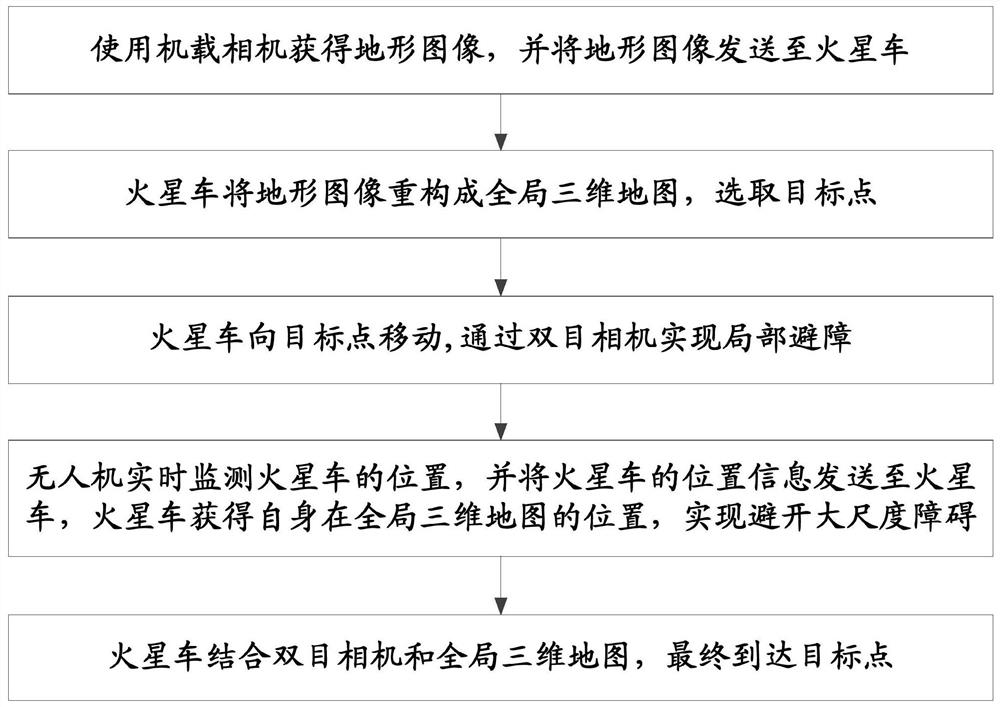
[0023] In view of the problem that extraterrestrial exploration vehicles pay more attention to local positioning and path planning, and carry out walking detection in the detection area, without global detection and navigation to and from detection bases, this invention proposes a visual navigation of the Mars rover combining global maps and local maps The method can improve the global positioning ability of the extraterrestrial object detection vehicle, and effectively improve the efficiency of scientific detection.

[0024] A visual navigation method for Mars rover combining global map and local map, such as figure 1 As shown, it specifically includes the following steps:

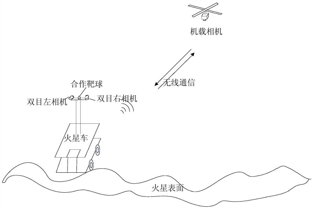
[0025] Step 1. The UAV is equipped with an airborne camera; before performing the scientific exploration mission, the high-altitude flying UAV takes off, uses the onboard camera to image the terrain of the are...


PUM


Abstract

The invention relates to a Mars rover visual navigation method combining a global map and a local map, and belongs to the field of high-precision navigation of extraterrestrial stars. The method comprises the following steps: 1, an unmanned aerial vehicle takes off, an airborne camera is used to image the terrain of a to-be-detected area around a Mars rover, and the terrain image is sent to the Mars rover; 2, the Mars rover reconstructs the topographic image into a global three-dimensional map, and selects a target point in the global three-dimensional map; 3, the Mars rover moves to a target point; the Mars rover realizes local obstacle avoidance through the binocular camera; 4, in the moving process of the Mars rover, the unmanned aerial vehicle monitors the position of the Mars rover in real time and sends the position information of the Mars rover to the Mars rover, the Mars rover obtains the position of the Mars rover in the global three-dimensional map, and large-scale obstacles are avoided; 5, the Mars rover combines the binocular camera and the global three-dimensional map to improve the global navigation precision. According to the invention, the global positioning capability of the extraterrestrial star probe vehicle is improved, and the efficiency of scientific detection is effectively improved.

Description

technical field [0001] The invention belongs to the field of high-precision navigation of extraterrestrial bodies, and relates to a Mars rover visual navigation method combining a global map and a local map. Background technique [0002] Optical cameras are widely used in visual navigation, and can be used in deep space exploration missions for Mars rover / lunar rover navigation, obstacle avoidance and path planning. With the deepening of deep space exploration missions, base construction and scientific exploration requirements on the surface of the moon / Mars are clear, and the local positioning and global positioning and navigation of the rover are essential key technologies. At present, the existing detection vehicles pay more attention to local positioning and path planning, and carry out walking detection in the detection area. There is no global detection and navigation method to and from the detection base. Contents of the invention [0003] The technical problem sol...

Claims


Application Information

Patent Timeline
IPC IPC(8): G01C21/24
CPCG01C21/24
Inventor 王立李涛华宝成刘洋王晓磊何健王云鹏刘鲁周益刘兴潭郝策
Owner BEIJING INST OF CONTROL ENG
Why Eureka
Try Eureka