Supercharge Your Innovation With Domain-Expert AI Agents!

Adaptive GNSS carrier phase difference landslide monitoring method

A carrier phase difference and carrier phase technology, applied in the field of satellite navigation and positioning, can solve the problems of fixed rate and poor positioning accuracy

Pending Publication Date: 2021-12-17
南宁桂电电子科技研究院有限公司 +1
View PDF0 Cites 0 Cited by
  • Summary
  • Abstract
  • Description
  • Claims
  • Application Information

AI Technical Summary

Problems solved by technology

[0003] The purpose of the present invention is to provide an adaptive GNSS carrier phase difference landslide monitoring method, aiming to solve the technical problems of the traditional high-precision differential positioning technology in the harsh observation environment of the fixed rate and poor positioning accuracy

Method used


Image

  • Adaptive GNSS carrier phase difference landslide monitoring method
  • Adaptive GNSS carrier phase difference landslide monitoring method
  • Adaptive GNSS carrier phase difference landslide monitoring method

Examples


Embodiment Construction

[0040] Embodiments of the present invention are described in detail below, examples of which are shown in the drawings, wherein the same or similar reference numerals designate the same or similar elements or elements having the same or similar functions throughout. The embodiments described below by referring to the figures are exemplary and are intended to explain the present invention and should not be construed as limiting the present invention.

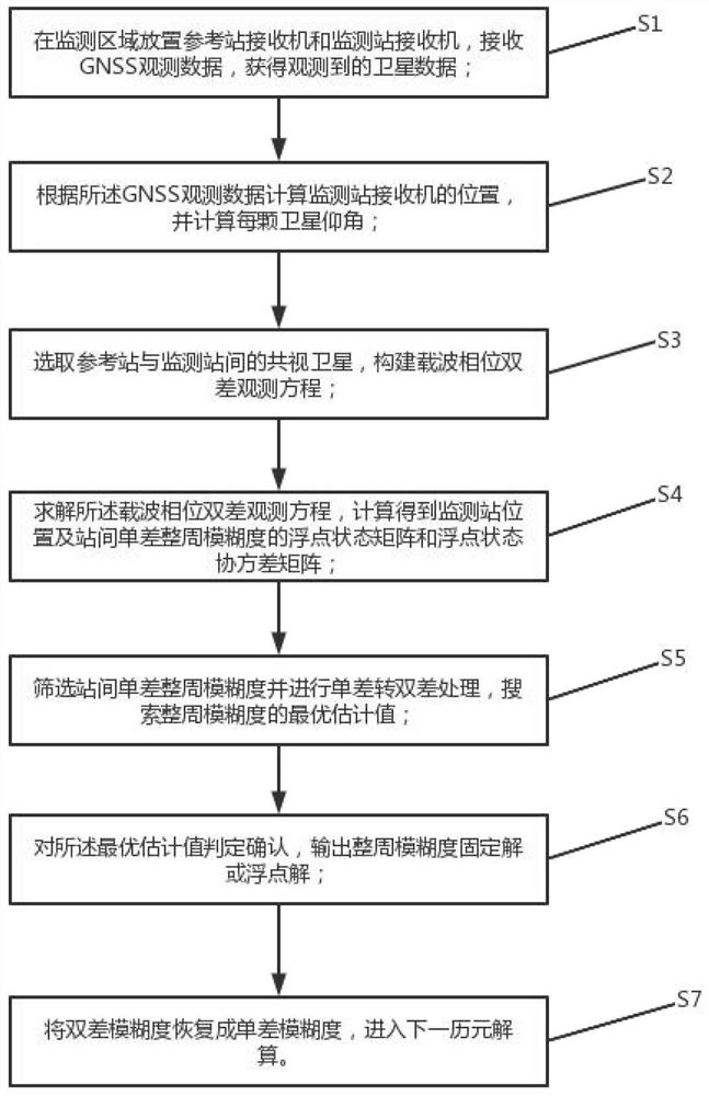
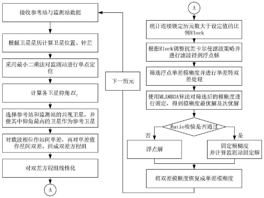
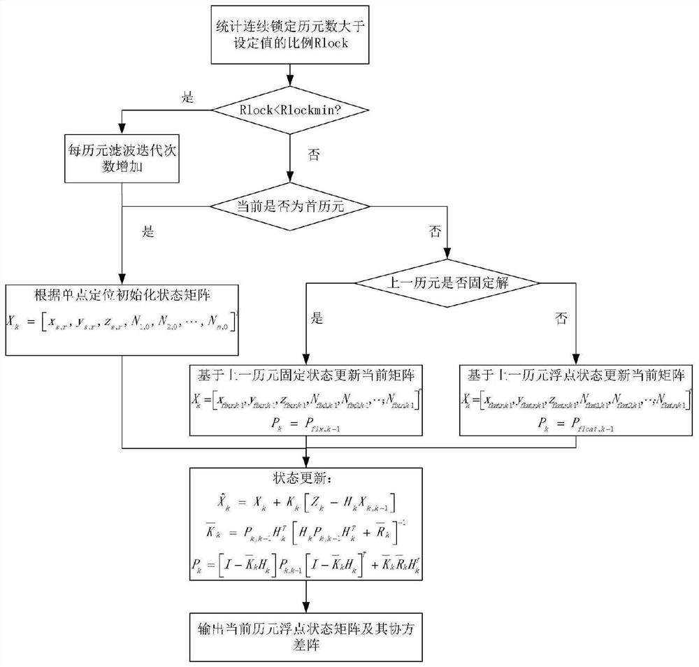
[0041] see figure 1 , the present invention proposes a kind of adaptive GNSS carrier phase differential landslide monitoring method, comprising the following steps:

[0042] S1. Place a reference station receiver and a monitoring station receiver in the monitoring area to receive GNSS observation data and obtain observed satellite data;

[0043] S2. Calculate the position of the monitoring station receiver according to the GNSS observation data, and calculate the elevation angle of each satellite;

[0044] S3. Select the common...


PUM


Abstract

The invention discloses an adaptive GNSS carrier phase difference landslide monitoring method, which comprises the steps of receiving GNSS observation data of a monitoring station and a reference station to obtain a pseudo range, a carrier phase and a carrier-to-noise ratio of an observed satellite, performing double-difference on carrier phase observation quantity in the observation data to form a carrier phase double-difference observation equation set, resolving through robust Kalman filtering to obtain a floating point solution of the position of the monitoring station, screening integer ambiguity parameters of a carrier phase by eliminating satellites with poor observation quality, searching integer ambiguity by adopting an MLAMBDA algorithm, finally obtaining a fixed solution of the position of the monitoring station, further counting the proportion of the continuous locking epoch number of all satellites greater than a set value, and comparing the proportion with a set proportion value, automatically adjusting a filtering strategy, and combining the advantages of continuous calculation and single epoch calculation so as to guarantee the fixed rate and the positioning precision in the severe observation environment.

Description

technical field [0001] The invention relates to the technical field of satellite navigation and positioning, in particular to an adaptive GNSS carrier phase difference landslide monitoring method. Background technique [0002] With the development of Global Navigation Satellite System (GNSS, Global Navigation Satellite System), high-precision differential positioning technology has been widely used in high-precision monitoring fields such as landslides. Traditional high-precision differential positioning technology usually constructs carrier phase double-difference observation equation to obtain high-precision positioning results through Kalman filter technology, but when the observation environment is poor, using traditional Kalman filter technology and the method of fixing all ambiguities usually occurs Frequent cycle slips, difficult fixation, and poor precision. . Contents of the invention [0003] The purpose of the present invention is to provide an adaptive GNSS c...

Claims


Application Information

Patent Timeline
IPC IPC(8): G01S19/44G01S19/37
CPCG01S19/44G01S19/37
Inventor 孙希延梁维彬鞠涛杜洋付文涛
Owner 南宁桂电电子科技研究院有限公司
Features
  • R&D
  • Intellectual Property
  • Life Sciences
  • Materials
  • Tech Scout
  • Unparalleled Data Quality
  • Higher Quality Content
  • 60% Fewer Hallucinations
Learn More