Grazing intensity monitoring method based on unmanned aerial vehicle remote sensing technology

A remote sensing technology and unmanned aerial vehicle (UAV) technology, which is applied in the field of grazing intensity monitoring based on UAV remote sensing technology. precise effect

Pending Publication Date: 2022-01-04
GRASSLAND RES INST OF CHINESE ACAD OF AGRI SCI
View PDF0 Cites 5 Cited by
  • Summary
  • Abstract
  • Description
  • Claims
  • Application Information

AI Technical Summary

Problems solved by technology

[0005] 1. For some high-resolution data (such as LandsatTM), due to the long repetition period, the growth of grassland vegetation affects the estimation accuracy of grazing intensity when estimating grazing intensity; while for NOAA-AVHRR, although the time resolution is very high, However, due to the low spatial resolution, it also affects the estimation accuracy of grazing intensity.
[0006] 2. When estimating the grazing intensity of each grassland type, it is assumed that the pasture growth in the study area is the same when establishing the prediction model. This assumption is suitable for grasslands with uniform growth, but for grasslands with significant differences in growth conditions, this method is used to calculate the grazing intensity prone to large errors
[0007] 3. For the estimation of livestock, it has been relying on the form of reporting by subordinates before, but it is difficult to distinguish the true and false data reported in this way. Most herdsmen will fill in false data in order to receive subsidies. There is no reliable data support for calculating grazing intensity

Method used


Image

  • Grazing intensity monitoring method based on unmanned aerial vehicle remote sensing technology
  • Grazing intensity monitoring method based on unmanned aerial vehicle remote sensing technology
  • Grazing intensity monitoring method based on unmanned aerial vehicle remote sensing technology

Examples


Embodiment

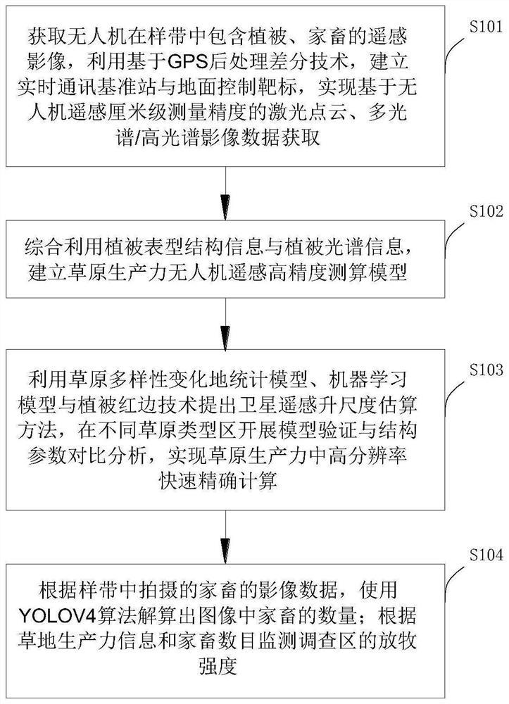
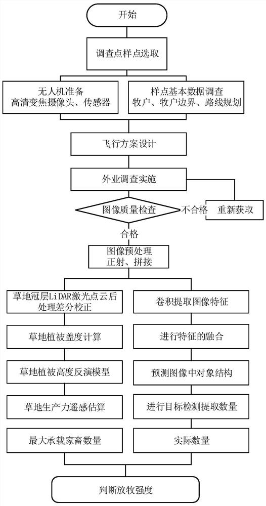
[0049] In order to better understand the implementation, the terms and definitions are now described as follows:

[0050] Pastoral areas: natural grassland areas dominated by herbivorous livestock grazing.

[0051] Unmanned aerial vehicle: An unmanned aerial vehicle operated by radio remote control equipment and self-contained program control device, or completely or intermittently operated autonomously by an on-board computer.

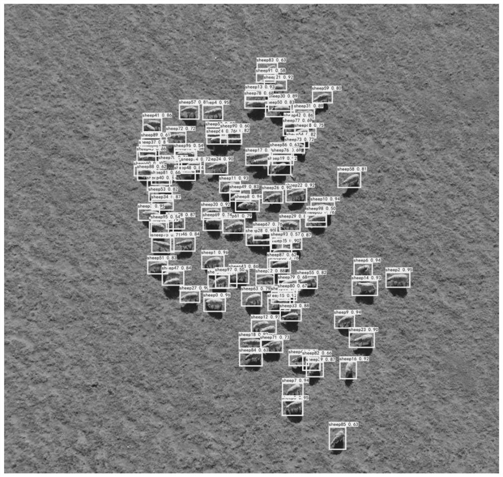
[0052] Livestock species: herbivorous mammals that have been domesticated through artificial breeding and are mainly used for grassland animal husbandry production. Examples include cattle, sheep (sheep and goats), horses, camels, etc.

[0053] Number of Livestock: The sum of all individual numbers of all types of livestock grazing at a specific time and within a specific grassland area.

[0054] Image interpretation: According to the spectral characteristics, spatial characteristics, time characteristics and imaging rules of the ground objects, ide...


PUM


Abstract

The invention discloses a pasture scale grazing intensity monitoring method based on an unmanned aerial vehicle remote sensing technology, and relates to the technical field of grazing intensity monitoring, and the method comprises the steps: building a real-time communication base station and a ground control target through employing a GPS-based post-processing difference technology, achieving laser point cloud and multispectral / hyperspectral image data acquisition based on centimeter-level measurement precision remote sensing of the unmanned aerial vehicle; establishing a grassland productivity unmanned aerial vehicle remote sensing high-precision measurement and calculation model; carrying out model verification and structure parameter comparative analysis in different grassland type areas, and achieving high-resolution rapid and accurate calculation in grassland productivity; calculating the number of the livestock in the image by using a YOLOV4 algorithm; and monitoring the grazing intensity of the investigation area according to the grassland productivity information and the number of livestock. According to the method, the unmanned aerial vehicle is used for monitoring the grazing meadow and counting the livestock in the meadow, manpower consumption is reduced, recording is clear, and the grazing state of the meadow can be monitored in real time.

Description

technical field [0001] The invention relates to the technical field of grazing intensity monitoring, in particular, to a method for monitoring grazing intensity based on UAV remote sensing technology. Background technique [0002] Grassland ecosystem is one of the most widely distributed and most important types of terrestrial ecosystems in the world. However, in recent years, with the growth of population and the doubling of the number of livestock, irrational grazing has caused serious damage to grassland ecosystems. Therefore, monitoring the actual grazing intensity of pastures and improving the grazing early warning mechanism have an irreplaceable important role and practical significance in guiding animal husbandry production and environmental protection. [0003] Studies on grazing intensity mainly focus on the effects of different grazing intensities on grassland vegetation community characteristics and grassland productivity diversity. Existing methods for estimatin...

Claims


Application Information

Patent Timeline
Patent Type & Authority Applications(China)
IPC IPC(8): G01S19/42G01J3/28G01N21/17G06K9/00G06K9/62G06T3/40G06T7/62
CPCG01S19/42G01N21/17G01J3/2823G06T3/4038G06T7/62G06T2207/10032G06T2207/30188G06T2207/30242G06T2207/30232G06T2200/32G01N2021/1793G01J2003/2826G06F18/24
Inventor 吕鹏飞李飞运向军哈斯巴根路艳峰白海花
Owner GRASSLAND RES INST OF CHINESE ACAD OF AGRI SCI
Why Eureka
Try Eureka