Surveying and mapping data acquisition device for constructional engineering based on unmanned aerial vehicle oblique photography technology

A technology of oblique photography and construction engineering, which is applied in surveying devices, photogrammetry/video surveying, surveying and navigation, etc., which can solve the problems of lack of novelty and poor overall functionality, reduce the occupied space and improve the usability. , the effect of improving work efficiency

Pending Publication Date: 2022-01-14
重庆建筑科技职业学院
View PDF3 Cites 0 Cited by
  • Summary
  • Abstract
  • Description
  • Claims
  • Application Information

AI Technical Summary

Problems solved by technology

The surveying and mapping device for construction engineering can fold and store multiple sets of first connecting rods through the hinged seat, which is convenient for the operator to store and fold the surveying and mapping device." Data acquisition device, but the overall functionality of the above-mentioned device is poor, making it difficult to provide more assistance to the staff, so it does not have a good novelty

Method used


Image

  • Surveying and mapping data acquisition device for constructional engineering based on unmanned aerial vehicle oblique photography technology
  • Surveying and mapping data acquisition device for constructional engineering based on unmanned aerial vehicle oblique photography technology
  • Surveying and mapping data acquisition device for constructional engineering based on unmanned aerial vehicle oblique photography technology

Examples


Embodiment 1

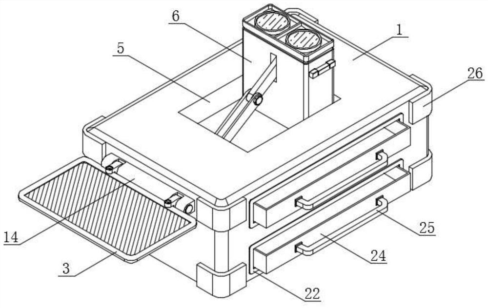
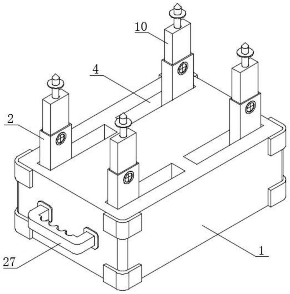
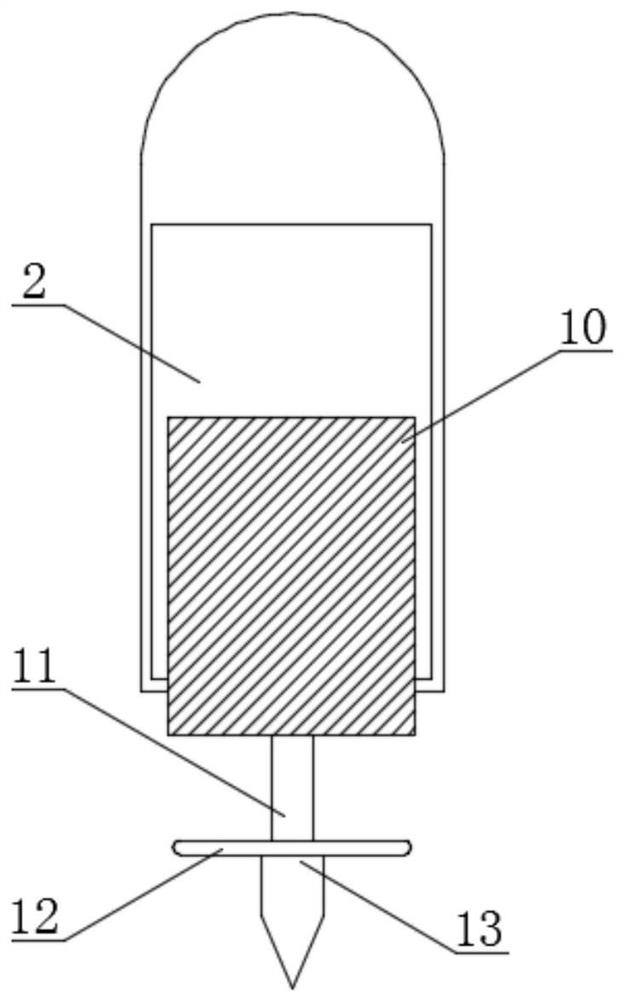
[0035] see figure 1 , figure 2 , image 3 , Image 6 and Figure 7 , a kind of embodiment that the present invention provides, the construction engineering surveying and mapping data acquisition device based on unmanned aerial vehicle oblique photography technology, comprises working box 1, fixed sleeve 2 and working plate 3, and the surrounding place of working box 1 bottom is all provided with The fixed sleeve 2 is provided with a working plate 3 on one side of the working box 1; the bottom of the working box 1 is provided with a limit groove 4, and the fixed sleeve 2 is located inside the limit groove 4, and the top of the fixed sleeve 2 and the limit The intersecting part of the slot 4 is provided with a damping shaft; the middle part of the top of the working box 1 is provided with a placement slot 5, and the interior of the placement slot 5 is provided with a laser rangefinder body 6, and the middle part of the bottom of the laser rangefinder body 6 is provided with ...

Embodiment 2

[0038] see Figure 4 and Figure 5 , a kind of embodiment that the present invention provides, the construction engineering surveying and mapping data acquisition device based on unmanned aerial vehicle oblique photography technology, comprises working plate 3, and the top of work box 1 side is equipped with fixing clip 14, and the internal connection of fixing clip 14 There is a fixed locking tooth 15, and the internal thread of the fixed locking tooth 15 is connected to one side of the working plate 3, the middle part of the working box 1 side is provided with a limit chute, and the inside of the limit chute is slidingly connected to the limit slide block 16, One side of limit slide block 16 is provided with movable clip 17, and the inside of movable clip 17 is provided with movable rod 18, and the top of movable rod 18 is connected with transmission rod 19, and the intersecting place of movable rod 18 and transmission rod 19 is threadedly connected with Fix the bolt, and t...

Embodiment 3

[0041] see figure 1 and Figure 8 , a kind of embodiment that the present invention provides, the construction engineering surveying and mapping data acquisition device based on unmanned aerial vehicle oblique photography technology, comprises storage tank 23, and the top of laser rangefinder body 6 is equipped with protective lens 20, and laser rangefinder body 6. A horizontal column 21 is installed on the top of one side, and a fixing groove 22 is provided at the upper and lower ends of the surface of the working box 1. The inside of the fixing groove 22 is slidably connected with a storage groove 23, and the inside of the storage groove 23 is equipped with a partition plate 24. A handle 25 is installed on the surface of the storage tank 23, a protective angle 26 is installed at the four corners of the top and bottom of the work box 1, and a handle 27 is installed at the middle of the work box 1 side;

[0042] Through the setting of the storage tank 23, when the staff needs...


PUM


Abstract

The invention discloses a surveying and mapping data acquisition device for constructional engineering based on an unmanned aerial vehicle oblique photography technology. The surveying and mapping data acquisition device comprises a working box, fixed sleeves and a working plate, the fixed sleeves are arranged around the bottom of the working box, the working plate is arranged on one side of the working box, and a limiting groove is formed in the bottom of the working box. Through the arrangement of the fixed sleeves and a laser range finder body, the arrangement of a placing groove, the laser range finder body, a supporting rod and a fastening knob, and the matched use of the fixed sleeves and adjusting plates, the extension length of the structure can be quickly adjusted, and the four adjusting plates sequentially extend to different lengths according to different terrains. Therefore, the whole working box can be kept stable, the structure can be conveniently inserted into the ground in a more labor-saving manner by a worker through the arrangement of a ground pricking cone, whether the whole device is kept horizontal or not can be determined by the worker through observing whether a water source in a horizontal column is kept horizontal or not through the arrangement of the horizontal column, and therefore the measurement precision of the device is improved.

Description

technical field [0001] The invention relates to the technical field of construction engineering data acquisition, in particular to a surveying and mapping data acquisition device for construction engineering based on unmanned aerial vehicle oblique photography technology. Background technique [0002] Architectural engineering is mainly responsible for the teaching and management of civil engineering in the direction of architectural engineering. It mainly cultivates and masters the basic theories and basic knowledge of engineering mechanics, soil mechanics, surveying, building architecture and structural engineering. Specific values ​​such as the height of the building are surveyed and mapped, but the existing surveying and mapping data acquisition device still has a certain middle part in actual use. [0003] In the prior art, the surveying and mapping data acquisition device for construction engineering based on UAV oblique photography technology has disadvantages: [00...

Claims


Application Information

Patent Timeline
Patent Type & Authority Applications(China)
IPC IPC(8): G01C11/00G01C15/00G01S17/08
CPCG01C11/00G01C15/00G01S17/08Y02A90/30
Inventor 刘静李超郑亚清
Owner 重庆建筑科技职业学院
Why Eureka
Try Eureka