
Hierarchical nonlinear subspace dictionary learning method for remote sensing image scene classification

A dictionary learning and scene classification technology, applied in the field of remote sensing image processing, can solve the problems of time-consuming, classification performance disaster, dictionary learning memory usage and increased computational complexity, and achieve good classification performance

Pending Publication Date: 2022-01-21
CHANGZHOU INST OF LIGHT IND TECH
View PDF0 Cites 1 Cited by
  • Summary
  • Abstract
  • Description
  • Claims
  • Application Information

AI Technical Summary

Problems solved by technology

Second, training a dynamic learning model often requires a large number of annotated samples, however, it is difficult and time-consuming to annotate a large number of remote sensing images in new scenes
Third, the high spatial resolution and rich spectral information of remote sensing images make it difficult to directly construct deep learning models for classification
However, the shortcomings of the methods proposed so far are that they all perform dictionary learning in the original space of samples. First, due to the high-dimensional characteristics of remote sensing images, the memory usage and computational complexity in dictionary learning increase sharply with the increase in dimensionality. Performance also suffers from the curse of dimensionality
Second, for complex problems such as classification of remote sensing images, the nonlinear relationship between samples cannot be well utilized in the original space of samples
Although they are easy to implement, they may not fully preserve the best properties of dictionary learning, since most of these methods just perform dimensionality reduction and dictionary learning as two separate stages

Method used


Image

  • Hierarchical nonlinear subspace dictionary learning method for remote sensing image scene classification
  • Hierarchical nonlinear subspace dictionary learning method for remote sensing image scene classification
  • Hierarchical nonlinear subspace dictionary learning method for remote sensing image scene classification

Examples


Embodiment Construction

[0087] The technical solution of the present invention will be further described in detail below in conjunction with the accompanying drawings.

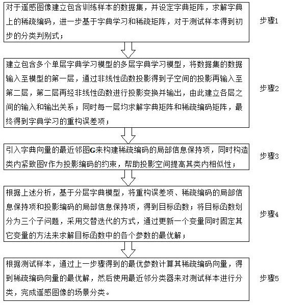
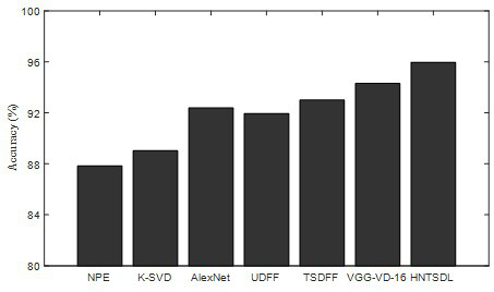
[0088] The present invention proposes a hierarchical nonlinear subspace dictionary learning (Hierarchical nonlinear subspace dictionary learning, HNSDL) method. A large number of literatures show that spatial information can improve the accuracy of remote sensing image classification. Inspired by multi-layer dictionary learning, HNSDL uses a hierarchical nonlinear method to project data samples into a series of subspaces and achieve data dimensionality reduction. In order to improve the discriminative ability of the model, a local structure constraint term of sparse coding is introduced in the learning process. Experiments on multiple real remote sensing image datasets show that the proposed method is effective for remote sensing image scene classification. Specifically, the main contributions of the present invention can be summar...


PUM


Abstract

The invention discloses a hierarchical nonlinear subspace dictionary learning method for remote sensing image scene classification. HNSDL projects a data sample into a series of subspaces by using a hierarchical nonlinear method and realizes data dimension reduction; in order to improve the identification capability of the model, a local structure constraint term of sparse coding is introduced in the learning process. The method has the following technical progress that: (1) different from the existing linear method of a linear transformation matrix, the proposed method maps data to a series of projection spaces through a series of nonlinear functions; compared with a linear transformation matrix, the nonlinear projection can better represent the nonlinear structure of the remote sensing image. And (2) by utilizing a local structure constraint item with label information, dictionary learning not only retains a nonlinear local structure of data, but also enables intra-class samples to be compact, and the class separability of the dictionary is enhanced. And (3) projection space learning and dictionary learning are simultaneously learned in one model, and an alternative iterative optimization method is used for parameter optimization, so that the parameters of the model can simultaneously obtain optimal solutions.

Description

technical field [0001] The invention relates to the field of remote sensing image processing, in particular to a hierarchical non-linear subspace dictionary learning method for scene classification of remote sensing images. Background technique [0002] With the rapid development of many fields such as computer science, remote sensing, and communication engineering, remote sensing images have exploded, making large-scale surface monitoring possible. Automatic land cover classification based on remote sensing images has important application value in urban planning. Land cover classification of remote sensing images is usually based on supervised learning methods, and many machine learning models, such as support vector machines, Markov random fields, random forests, etc., have been widely used in hyperspectral image classification. However, these methods only consider the spectral features of remote sensing images, while ignoring the sparsity and spatial information hidden ...

Claims


Application Information

Patent Timeline
IPC IPC(8): G06V10/77G06V10/772G06V10/774G06V10/776G06V10/764G06V20/10G06V20/13G06K9/62
CPCG06F18/21322G06F18/21328G06F18/2136G06F18/28G06F18/217G06F18/24147G06F18/214
Inventor 周国华陆兵徐亦卿申燕萍
Owner CHANGZHOU INST OF LIGHT IND TECH
Learn More