Unmanned aerial vehicle topographic survey system

A survey system and unmanned aerial vehicle technology, applied in the field of unmanned aerial vehicles, can solve the problems of low terrain efficiency, lost construction workers, high time cost, etc., to avoid potential safety hazards and damage, realize multi-functionality, and increase the scope of application Effect

Inactive Publication Date: 2022-02-08
金田产业发展(山东)集团有限公司
View PDF10 Cites 0 Cited by
  • Summary
  • Abstract
  • Description
  • Claims
  • Application Information

AI Technical Summary

Problems solved by technology

[0003] At present, manual terrain survey is also a commonly used technical survey method, but the efficiency of manual terrain survey is extremely low, it consumes a lot of manpower and material resources, the time cost is large, and due to the large terrain gap and the error of personnel survey , so that the accuracy of manual survey is not high, and the effect is not ideal
Although the use of unmanned aerial vehicles to survey the terrain has appeared in the prior art, the unmanned aerial vehicles in the prior art only have the function of surveying the terrain and have relatively few functions. They can only be used for surveying the terrain. If a fire breaks out, or construction workers get lost in the mountains, the efficiency of human search and rescue is relatively low, and the prime time for search and rescue is delayed.

Method used


Image

  • Unmanned aerial vehicle topographic survey system
  • Unmanned aerial vehicle topographic survey system

Examples


Embodiment

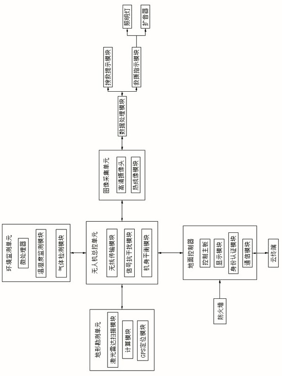
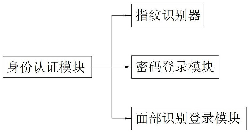
[0034] see Figure 1 to Figure 2, an unmanned aerial vehicle terrain survey system, comprising a ground controller, an unmanned aerial vehicle master control unit, a terrain survey unit, an image acquisition unit and an environmental monitoring unit, the ground controller is wirelessly connected to the unmanned aerial vehicle master control unit, The terrain survey unit, the image acquisition unit and the environmental monitoring unit are all connected to the UAV master control unit and electrically connected, the image acquisition unit is electrically connected to a data processing module, and the data processing module is electrically connected to a search and rescue prompt module and a rescue indication module, the rescue indication module consists of a lighting lamp and a loudspeaker, the lighting lamp is an LED strong lighting lamp, and the loudspeaker is controlled by the UAV master control unit and forms a wireless connection with the ground controller. connection, the ...


PUM


Abstract

The invention discloses an unmanned aerial vehicle topographic survey system, which comprises a ground controller, an unmanned aerial vehicle master control unit, a topographic survey unit, an image acquisition unit and an environment monitoring unit. A high-definition camera in the image acquisition unit can be used for knowing the real appearance of the terrain when surveying the terrain in a mountain, if a worker gets lost in a mountain forest or a fire department uses the unmanned aerial vehicle to search and rescue the worker, the worker can be searched and rescued through the thermal imaging module, and when an object with heat appears, a search and rescue prompt module feeds back to the ground controller layer by layer, and then combined use with the high-definition camera in an image acquisition module is conducted, a GPS positioning module is used for positioning the object if the object is a search and rescue target, people go out to rescue the search and rescue target, a loudspeaker in a rescue indication module is manually guided by combining a landform surveyed by a landform surveying unit, people are helped to be quickly rescued, and the rescue efficiency is improved.

Description

technical field [0001] The invention relates to the field of unmanned aerial vehicles, and more specifically, relates to an unmanned aerial vehicle terrain survey system. Background technique [0002] Unmanned aircraft is referred to as "unmanned aerial vehicle" or "UAV" in English. It is an unmanned aircraft operated by radio remote control equipment and self-contained program control device, or completely or intermittently operated autonomously by an on-board computer; With the development of our country's economy, the demand for roads is increasing day by day. Geological surveys are required before roads are built. The topographic maps that people see that reflect the shape and appearance of the earth's surface are quite complicated. Whether it is a mountainous area with undulating topography or a watery plain with dense rivers, lakes and ponds, the various landforms and feature symbols on the map accurately reflect the actual situation on the ground. [0003] At present...

Claims


Application Information

Patent Timeline
Patent Type & Authority Applications(China)
IPC IPC(8): B64C39/02G06F21/31
CPCB64C39/024G06F21/31B64U2101/00B64U2101/30B64U2201/20
Inventor 张然孟卉吕世厚
Owner 金田产业发展(山东)集团有限公司
Why Eureka
Try Eureka