Urban engineering planning method and system based on unmanned aerial vehicle remote sensing surveying and mapping

An urban planning and machine remote sensing technology, applied in mechanical equipment, combustion engines, internal combustion piston engines, etc., can solve problems such as the inability to obtain planning methods quickly, the large amount of calculation of computer systems, and the low efficiency of drawing design, so as to improve design efficiency, The effect of optimizing the construction sequence and reducing the amount of calculation

Active Publication Date: 2022-02-18
SHANDONG GEO-SURVEYING & MAPPING INST
View PDF7 Cites 5 Cited by
  • Summary
  • Abstract
  • Description
  • Claims
  • Application Information

AI Technical Summary

Problems solved by technology

[0003] In the prior art, in urban planning engineering, such as natural gas pipeline planning engineering, sewer pipeline planning engineering, sidewalk planning engineering, and cable line planning engineering, in the process of engineering planning, the calculation amount of the computer system is too large, and it cannot be obtained quickly. Planning methods; and most urban planning projects require manual field investigation of the actual situation, resulting in low efficiency in the early stage of urban engineering drawings

Method used


Image

  • Urban engineering planning method and system based on unmanned aerial vehicle remote sensing surveying and mapping
  • Urban engineering planning method and system based on unmanned aerial vehicle remote sensing surveying and mapping
  • Urban engineering planning method and system based on unmanned aerial vehicle remote sensing surveying and mapping

Examples


Embodiment Construction

[0070] In order to understand the above-mentioned purpose, features and advantages of the present invention more clearly, the present invention will be further described in detail below in conjunction with the accompanying drawings and specific embodiments. It should be noted that, in the case of no conflict, the embodiments of the present application and the features in the embodiments can be combined with each other.

[0071] In the following description, many specific details are set forth in order to fully understand the present invention. However, the present invention can also be implemented in other ways different from those described here. Therefore, the protection scope of the present invention is not limited by the specific details disclosed below. EXAMPLE LIMITATIONS.

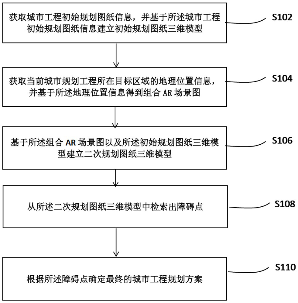
[0072] The first aspect of the present invention provides an urban engineering planning method based on UAV remote sensing mapping, comprising the following steps:

[0073] S102: Obtain the informat...


PUM


Abstract

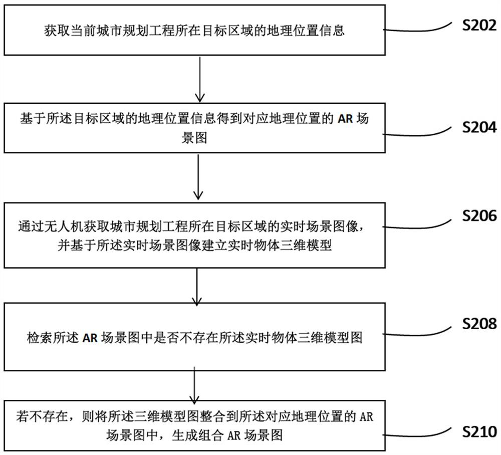
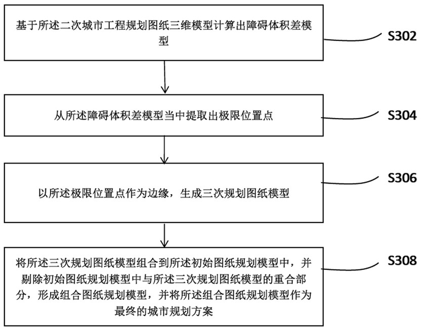
The invention relates to an urban engineering planning method based on unmanned aerial vehicle remote sensing surveying and mapping, and belongs to the technical field of urban planning. The method comprises the steps: obtaining initial planning drawing information of urban engineering, and building an initial planning drawing three-dimensional model based on the initial planning drawing information of the urban engineering; obtaining geographical location information of a target area where the current urban planning project is located, and obtaining a combined AR scene graph based on the geographical location information; establishing a secondary planning drawing three-dimensional model based on the combined AR scene graph and the initial planning drawing three-dimensional model; searching an obstacle point from the three-dimensional model of the quadratic programming drawing; and determining a final urban engineering planning scheme according to the obstacle points. During urban planning, the AR scene technology can be directly used, the unmanned aerial vehicle remote sensing surveying and mapping technology is utilized to integrate the lacked scene model into the AR scene, and the calculation amount of a computer system can be reduced by utilizing the technology, so that the calculation efficiency of urban engineering planning is improved.

Description

technical field [0001] The invention relates to the technical field of urban planning, in particular to an urban engineering planning method and system based on remote sensing mapping of drones. Background technique [0002] With the rapid development of modern surveying and mapping science and technology, the acquisition and processing capabilities of surveying and mapping geographic data have been greatly improved. From satellites, aviation, and low-altitude drones to ground surveying robots and underground geophysical radars, an integrated space-ground information acquisition and processing capability has been formed. . In my country, especially in the past 20 years, the state and various provinces and cities have promoted a series of major surveying and mapping geographic projects, and accumulated massive surveying and mapping geographic data, including multi-source remote sensing image data, basic geospatial data, urban underground pipeline data, and urban underground s...

Claims


Application Information

Patent Timeline
Patent Type & Authority Applications(China)
IPC IPC(8): G06F30/13G06T17/00G06T19/00
CPCG06F30/13G06T17/00G06T19/006Y02T10/40
Inventor 刘金苹赵德良卢茜茜
Owner SHANDONG GEO-SURVEYING & MAPPING INST
Why Eureka
Try Eureka