Land space planning building measuring device

A technology of space planning and measuring device, applied in the field of architectural surveying and mapping, can solve the problems of reduced measurement accuracy, slow leveling speed, poor stability, etc., and achieve the effects of preventing shaking, improving accuracy, and preventing shaking again.

Inactive Publication Date: 2022-03-01
陶花明
View PDF0 Cites 5 Cited by
  • Summary
  • Abstract
  • Description
  • Claims
  • Application Information

AI Technical Summary

Problems solved by technology

[0002] Surveying and mapping is literally understood as surveying and drawing. It is based on computer technology, photoelectric technology, network communication technology, space science, and information science. It takes global navigation satellite positioning system, remote sensing, and geographic information system as its technical core, and selects existing features on the ground. Points and boundaries, and obtain graphics and position information reflecting the current situation of the ground by means of measurement, for engineering construction, planning and design, and administrative management. The current GPS surveying instrument needs to be leveled w

Method used


Image

  • Land space planning building measuring device
  • Land space planning building measuring device
  • Land space planning building measuring device

Examples


Embodiment Construction

[0033] The present invention will be further described below in conjunction with the accompanying drawings and embodiments.

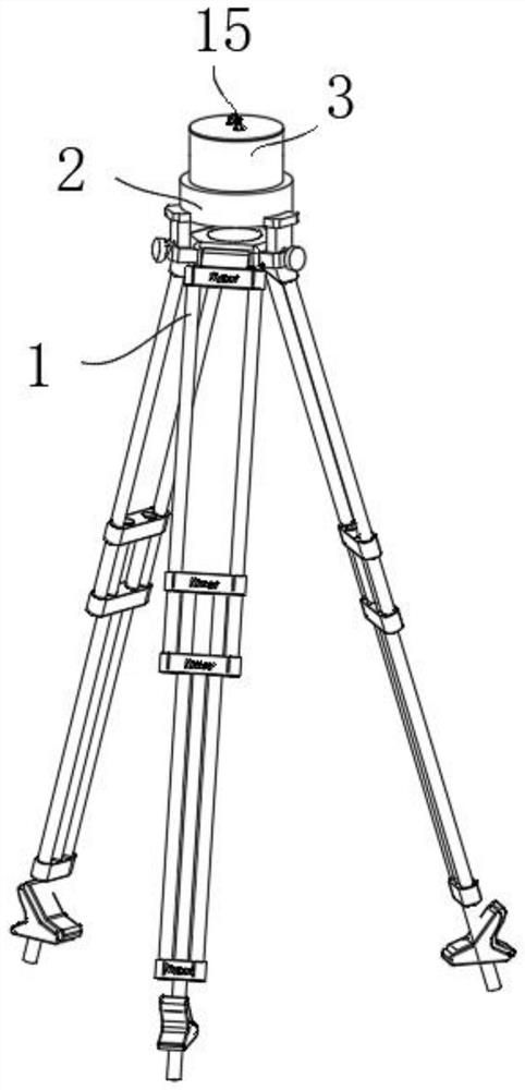
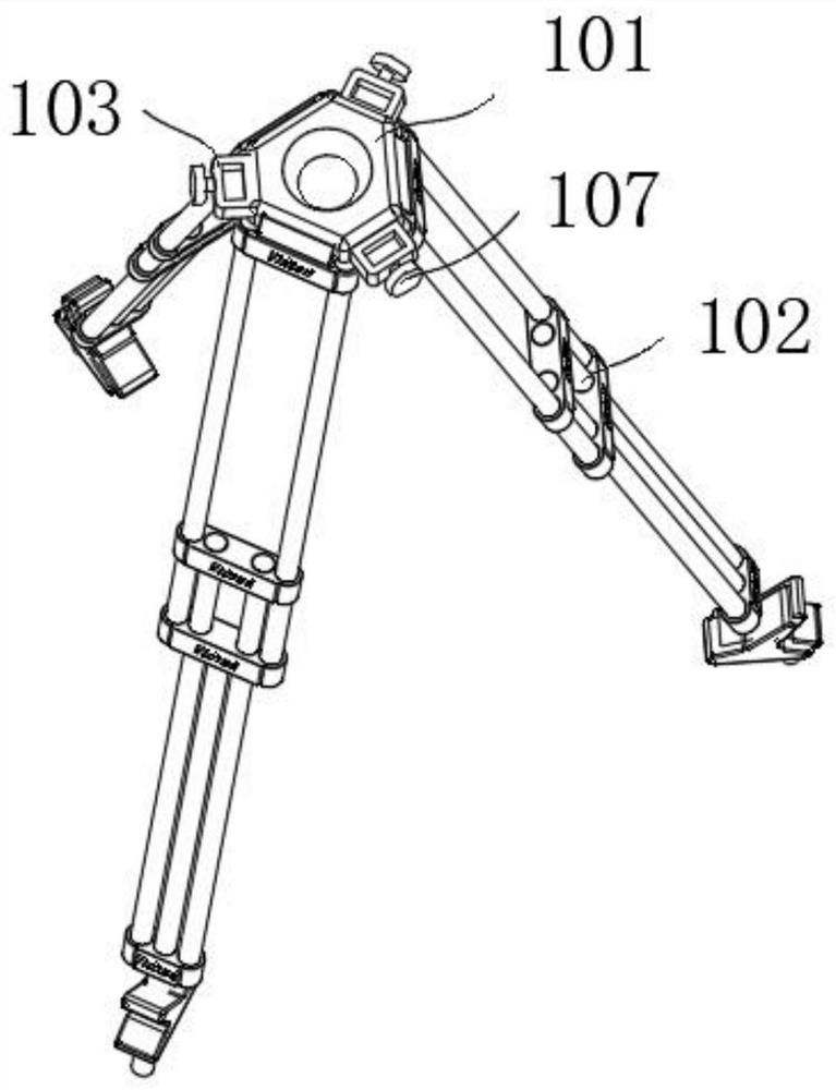
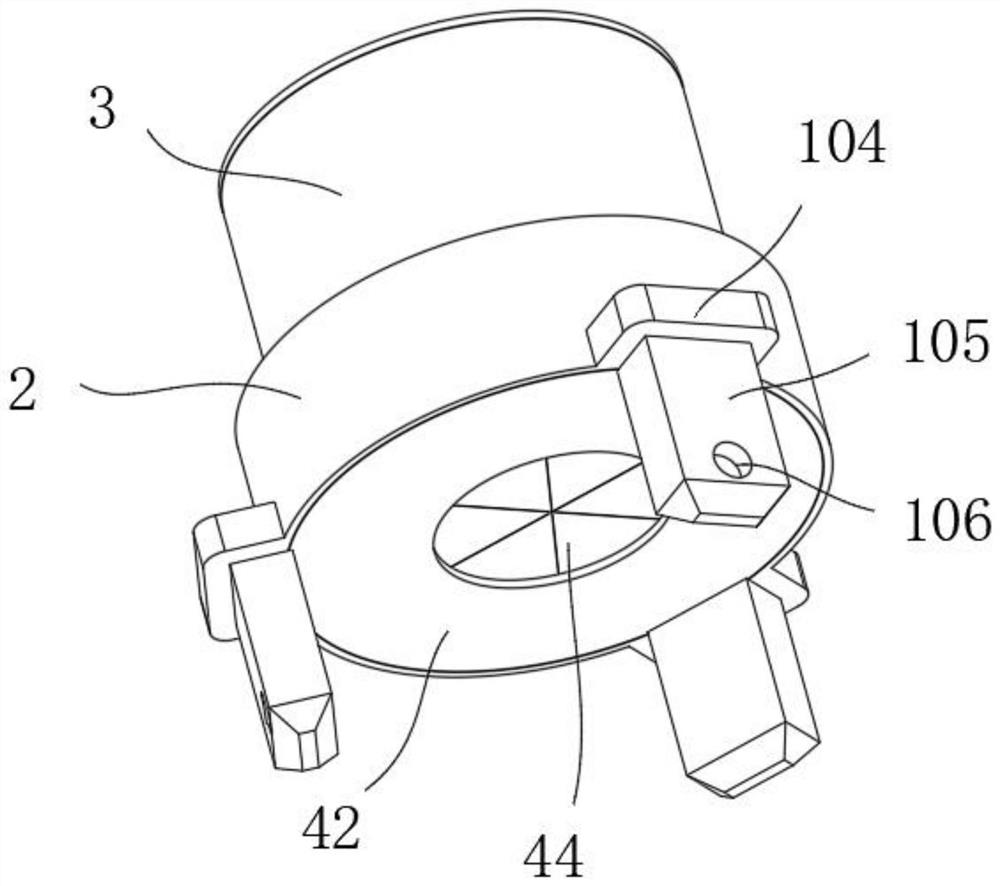
[0034] In the specific implementation process, such as Figure 1-7 with Figure 13 Shown, a kind of land space planning building surveying device is characterized in that, comprises: tripod 1, fixed sealing mechanism 4, lifting mechanism 5, single-point fixing mechanism 6, fixed plate 7, pendulum 10 and GPS surveying instrument 12, so The top of the tripod 1 is detachably fixed with a first shell 2, the top of the first shell 2 is fixed with a second shell 3, the top of the second shell 3 is fixed with a handle 15, and the fixed sealing mechanism 4 is slidably installed on the first The inner wall of the shell 2, the lifting mechanism 5 is installed on the inner wall of the first shell 2, and is used to drive the lifting of the fixed sealing mechanism 4, the fixed plate 7 is fixed on the inner wall of the second shell 3, and a through hole is opened in...


PUM


Abstract

The invention provides a territorial space planning building measuring device, which is characterized by comprising a tripod, a fixed sealing mechanism, a lifting mechanism, a single-point fixing mechanism, a fixing plate, a swing rod and a GPS surveying instrument, a first shell is detachably fixed at the top of the tripod, a second shell is fixed at the top of the first shell, the fixed sealing mechanism is slidably mounted on the inner wall of the first shell, and the lifting mechanism is slidably mounted on the inner wall of the first shell. The lifting mechanism is installed on the inner wall of the first shell and used for driving the fixed sealing mechanism to ascend and descend, the fixing plate is fixed to the inner wall of the second shell, and a through hole is formed in the middle of the fixing plate. The GPS surveying and mapping instrument can be automatically leveled on the tripod, surveying and mapping efficiency is improved, the GPS surveying and mapping instrument is arranged in the second shell, the GPS surveying and mapping instrument can be limited and fixed after being leveled, influences of external factors are prevented, stability is improved, the horizontal state can be detected in real time, surveying and mapping precision is improved, and the GPS surveying and mapping instrument is suitable for popularization and application. And the GPS surveying instrument can be clamped, fixed and protected when not used or moved, so that the safety is improved.

Description

technical field [0001] The invention relates to the technical field of building surveying and mapping, in particular to a building measuring device for land space planning. Background technique [0002] Surveying and mapping is literally understood as surveying and drawing. It is based on computer technology, photoelectric technology, network communication technology, space science, and information science. It takes global navigation satellite positioning system, remote sensing, and geographic information system as its technical core, and selects existing features on the ground. Points and boundaries, and obtain graphics and position information reflecting the current situation of the ground by means of measurement, for engineering construction, planning and design, and administrative management. The current GPS surveying instrument needs to be leveled when in use, while the existing surveying instrument is mostly supported by a vertical pole, and then the level of the verti...

Claims


Application Information

Patent Timeline
IPC IPC(8): F16M11/04F16M11/08F16M11/32F16M11/36G01S19/14G01S17/08
CPCF16M11/046F16M11/08F16M11/32F16M11/36G01S19/14G01S17/08
Inventor 陶花明段金辉张悦悦
Owner 陶花明
Why Eureka
Try Eureka