
Method and system for demarcating mountain ranges

A technology of ranges and ranges, applied in the range delineation method and system of ranges, can solve the problems of lack of authoritative management organization management, protection of ecological environment, inconvenient application and analysis of disaster prevention and reduction work, lack of range and system research of ranges, etc. Achieving simple results

Active Publication Date: 2022-05-10
CHINESE ACAD OF SURVEYING & MAPPING
View PDF0 Cites 0 Cited by
  • Summary
  • Abstract
  • Description
  • Claims
  • Application Information

AI Technical Summary

Problems solved by technology

[0002] my country is a mountainous country, and the mountain area accounts for about two-thirds of the country's land area. Mountains play a pivotal role in natural resource management. At present, there is still a lack of clear boundary range and systematic research on mountain ranges, which can be obtained from public information The data is only a rough latitude and longitude range, and there is a lack of authoritative management agency management and mature standards to guide the demarcation of boundaries. Therefore, it is urgent to carry out research on the method of mountain range delineation

Method used


Image

  • Method and system for demarcating mountain ranges
  • Method and system for demarcating mountain ranges
  • Method and system for demarcating mountain ranges

Examples


Embodiment

[0173] Taking Yanshan Mountain as an example, the implementation steps of mountain boundary demarcation are as follows:

[0174] S1, collect related data of mountain range; Consult all kinds of documents and atlases, and make comprehensive analysis and judgment to obtain the following scope description:

[0175] Yanshan Mountain vertically spans Beijing, Hebei, Liaoning and Inner Mongolia, starting from Yanghe River in Wanquan County and Huai 'an County of Zhangjiakou City in the west, Shanhaiguan in the east, Bashang Plateau in the north, Tushan and Nuruhu Mountain in seven old, separated from Taihang Mountain by Guangou in the southwest, and Hebei Plain in the south.

[0176] Yanshan Mountain erodes and denudes the Zhongshan Mountain. The mountain is east-west, with an altitude of 500 ~ 1,500 meters, high in the northwest and low in the southeast. There are many low mountains and hills in the eastern section, generally below 1000 meters above sea level, and low mountains in the ...


PUM


Abstract

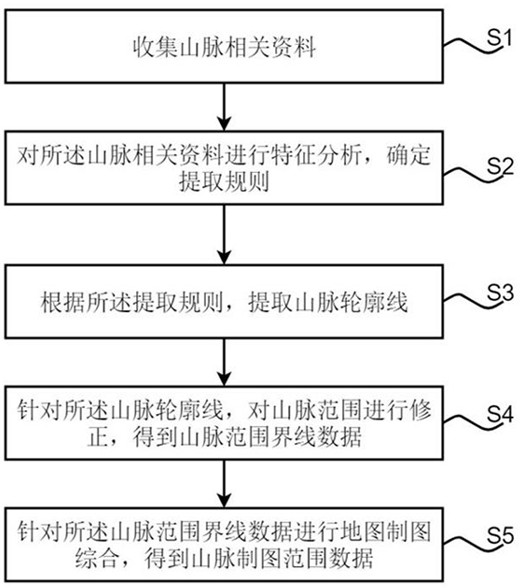
This application proposes a method and system for delineating the range of mountain ranges, which belongs to the field of digital terrain analysis. The method includes: collecting relevant data of mountain ranges; performing feature analysis on the relevant data of mountain ranges to determine the extraction rules; according to the extraction rules, extracting The mountain range outline; the range of the mountain range is corrected for the range of the mountain range to obtain boundary data of the range of the mountain range; the data of the boundary line of the range of the mountain range is synthesized by cartography to obtain the range data of the range of mountain range mapping. The system includes: a data collection module, a rule determination module, a contour extraction module, a mountain correction module, and a mountain synthesis module. The application can accurately delineate the mountain range and its range, and provides a practical and effective method for delimiting the range of the mountain range.

Description

Technical field [0001] The application belongs to the field of digital terrain analysis, and particularly relates to a method and a system for delineating mountain ranges. technical background [0002] China is a mountainous country, with mountainous areas accounting for about two-thirds of the country's land area. Mountains play an important role in the management of natural resources. At present, there is still a lack of clear boundary range and systematic research about mountains. The data that can be obtained in public information is only a rough latitude and longitude range, and there is a lack of authoritative management institutions and mature standards to guide boundary demarcation, which brings great benefits to the management of natural resources, the protection of ecological environment, disaster prevention and mitigation work and the application analysis of natural and humanistic aspects related to mountains. Inventive content [0003] Aiming at the above technical p...

Claims


Application Information

Patent Timeline
Patent Type & Authority Patents(China)
IPC IPC(8): G06F16/29G06T17/05
CPCG06F16/29G06T17/05
Inventor 康风光赵荣董春杨露
Owner CHINESE ACAD OF SURVEYING & MAPPING
Learn More