Sandstone type uranium deposit geological illustration mapping method

A sandstone type and uranium mine technology is applied in the field of geological illustration mapping of sandstone type uranium mines, which can solve the problems of increased workload, complicated calculation, large workload, etc., and achieves the effect of improving work efficiency and improving mapping accuracy.

Pending Publication Date: 2022-03-15
核工业二一六大队
View PDF0 Cites 0 Cited by
  • Summary
  • Abstract
  • Description
  • Claims
  • Application Information

AI Technical Summary

Problems solved by technology

[0002] In the past, the geological illustrations of sandstone-type uranium deposits were mostly done manually, with heavy workload and cumbersome calculations
[0003] With the improvement of the exploration level in the working area, a large amount of drilling data has been accumulated. In order to complete the geological illustration of sandstone-type uranium deposits, it is necessary to use the geological data formed by predecessors to form the latest and most complete geological illustration of sandstone-type uranium deposits, which needs to be reorganized , drawing, which greatly increases the workload and reduces work efficiency

Method used


Image

  • Sandstone type uranium deposit geological illustration mapping method

Examples


Embodiment Construction

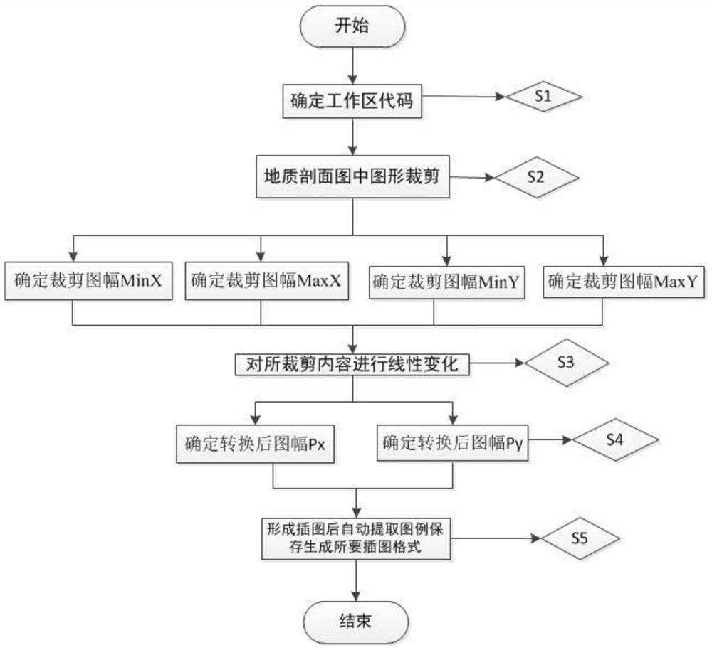
[0052] The present invention will be described in further detail below in conjunction with the accompanying drawings and specific embodiments.

[0053] A method for forming geological illustrations of sandstone-type uranium deposits, including the first step: setting the ten-digit code (6540220409) of the work area.

[0054] Among them, the first two digits are provincial codes, such as 65 in Xinjiang; the second two digits are regional codes, such as 40 in Yining City, Yili Prefecture; the third two digits are county codes, such as Chabucha Er County 22; the above three sets of data adopt the national natural division code.

[0055] The last four digits are the workspace number. Among them, the first two are the first letters of the name of the deposit, such as the Dala deposit, which is represented by D, 04, and L, 09; each deposit has a unique code, and the digital uranium exploration system can be intelligent Geographical coordinates of identified reserves are calculated...


PUM


Abstract

The invention belongs to the technical field of uranium mine digital exploration, and particularly relates to a sandstone type uranium mine geological illustration mapping method, which comprises the following steps of: 1, setting a ten-digit code of a working area; 2, on the geological profile map, rectangular sheet cutting is carried out; 3, linearly changing the rectangular cut content of the sheet in the geological profile map; and 4, carrying out automatic legend extraction on the cut sheet subjected to linear transformation by using digital uranium mine software. By utilizing the method, the automation and intelligentization of the whole process are realized, the working efficiency and the mapping precision are effectively improved, and a foundation is laid for newly calculating the resource reserves after the sample section of the resource reserve ore body engineering is changed.

Description

technical field [0001] The invention belongs to the technical field of uranium ore digital exploration, and in particular relates to a sandstone-type uranium ore geological illustration mapping method. Background technique [0002] In the past, the geological illustrations of sandstone-type uranium deposits were mostly done manually, with heavy workload and cumbersome calculations. [0003] With the improvement of the exploration level in the working area, a large amount of drilling data has been accumulated. In order to complete the geological illustration of sandstone-type uranium deposits, it is necessary to use the geological data formed by predecessors to form the latest and most complete geological illustration of sandstone-type uranium deposits, which needs to be reorganized , Drawing, greatly increased the workload and reduced work efficiency. Contents of the invention [0004] In view of the above deficiencies, the main purpose of the present invention is to prov...

Claims


Application Information

Patent Timeline
IPC IPC(8): G06T11/60
CPCG06T11/60
Inventor 乔淇师志龙张占峰王毛毛任满船李家金李彦龙陈晓东袁忠王守玉李旭
Owner 核工业二一六大队
Why Eureka
Try Eureka