Laser three-dimensional imaging radar ground target point cloud data processing method

A laser three-dimensional imaging, radar ground technology, applied in the direction of electromagnetic wave re-radiation, utilization of re-radiation, measurement devices, etc., to achieve the effect of improving computing speed and quickly realizing engineering

Pending Publication Date: 2022-03-18
SHANGHAI RADIO EQUIP RES INST
View PDF0 Cites 7 Cited by
  • Summary
  • Abstract
  • Description
  • Claims
  • Application Information

AI Technical Summary

Problems solved by technology

[0011] The purpose of the present invention is to provide a laser three-dimensional imaging radar ground target point cloud data processing method to solve the problem of ground target detection and recognition in co

Method used


Image

  • Laser three-dimensional imaging radar ground target point cloud data processing method
  • Laser three-dimensional imaging radar ground target point cloud data processing method
  • Laser three-dimensional imaging radar ground target point cloud data processing method

Examples


Embodiment Construction

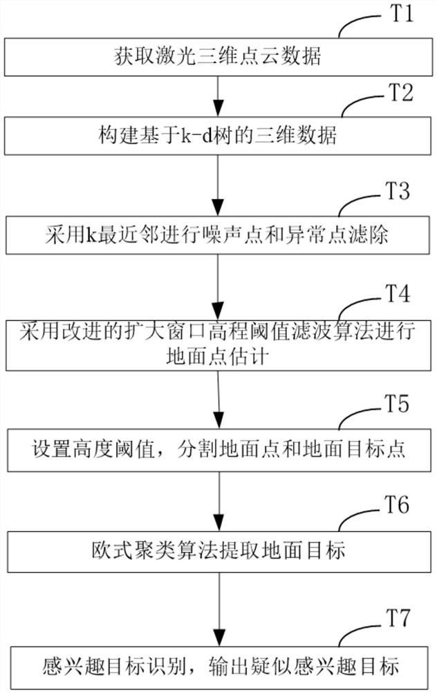
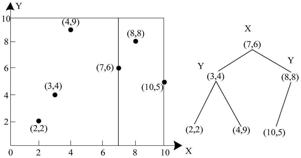
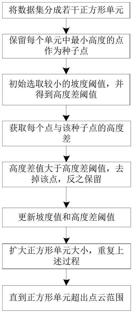
[0063] The method for processing the point cloud data of the laser three-dimensional imaging radar ground target proposed by the present invention will be further described in detail below in conjunction with the accompanying drawings and specific embodiments. The advantages and features of the present invention will become clearer from the following description. It should be noted that the drawings are in a very simplified form and all use inaccurate proportions, which are only used to facilitate and clearly illustrate the purpose of the implementation of the present invention, and are not used to limit the limiting conditions for the implementation of the present invention, so they do not have technical In the substantive meaning above, any modification of structure, change of proportional relationship or adjustment of size should still fall within the scope of the technical contents disclosed in the present invention without affecting the effects and goals that can be achiev...


PUM


Abstract

The invention provides a laser three-dimensional imaging radar ground target point cloud data processing method, which is used for carrying out ground target detection and identification on laser three-dimensional imaging radar point cloud data and outputting a suspected interested target, and comprises the following steps: S1, obtaining a point cloud data set of time and space registration; s2, filtering non-ground point data to obtain a ground point data set; s3, extracting, segmenting and summarizing the data of each ground target, and clustering and dividing the data into respective data subsets to obtain a ground target clustering set; and S4, performing interested target identification based on the ground target clustering set, and outputting the suspected interested target. The method is used for solving the problem of ground target detection and recognition in a complex scene, more three-dimensional information of the target is reserved, the operation speed is increased, and the method is more suitable for point cloud data real-time processing and engineering application.

Description

technical field [0001] The invention relates to the field of laser imaging, in particular to a method for processing laser three-dimensional imaging radar ground target point cloud data. Background technique [0002] Lidar is one of the most important technical means to solve three-dimensional imaging, and it is also a technology developed vigorously by developed countries such as the United States and Japan in the long-term planning of terrain mapping and ocean monitoring. The working method of laser radar is basically the same as that of microwave radar, but laser radar has a series of unique advantages: high angle resolution, high distance resolution and high speed resolution, and its anti-interference ability and anti-target stealth ability are strong. The speed measurement range is wide, and the imaging performance is more stable. Not only can the position information of the target be obtained, but also the speed information can be obtained. At the same time, it has the...

Claims


Application Information

Patent Timeline
IPC IPC(8): G01S17/89G01S7/48
CPCG01S17/89G01S7/4802
Inventor 孟宏峰奚银强晶晶陈蕙心王力
Owner SHANGHAI RADIO EQUIP RES INST
Why Eureka
Try Eureka