Method for calculating and calibrating river and lake water level based on satellite altimetry data

A technology of satellite altimetry and data calculation, which is applied in measuring devices, surveying and navigation, water resources assessment, etc., can solve the problems of non-continuous water area calculation and calibration accuracy cannot be guaranteed, achieve strong stability of calculation results, and improve usability , monitoring a wide range of effects

Pending Publication Date: 2022-04-05
NANJING HYDRAULIC RES INST
View PDF1 Cites 1 Cited by
  • Summary
  • Abstract
  • Description
  • Claims
  • Application Information

AI Technical Summary

Problems solved by technology

The invention can effectively solve the problem that the calculation a

Method used


Image

  • Method for calculating and calibrating river and lake water level based on satellite altimetry data
  • Method for calculating and calibrating river and lake water level based on satellite altimetry data
  • Method for calculating and calibrating river and lake water level based on satellite altimetry data

Examples


Embodiment

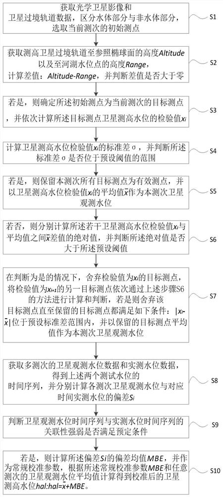
[0037] An embodiment of the present invention provides a method for calculating and calibrating river and lake water levels based on satellite altimetry data, figure 1 is a flowchart of an evaluation method according to an embodiment of the present invention, such as figure 1 shown, including:

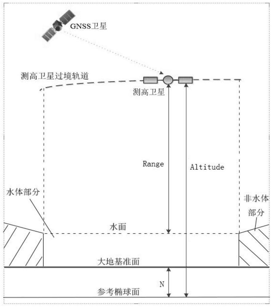
[0038] Step S1. Obtain the optical satellite image data of the target water area and the altimetry satellite transit orbit data closest to the target water area, preprocess the image and distinguish the water body part from the non-water body part, according to the boundary range of the water body part Randomly select several satellite altimetry points as the initial measurement points for the current survey.

[0039] In the specific implementation process, the preprocessing includes correcting and cutting the optical satellite images through professional software, such as using the professional software Brat to read, convert and output relevant parameters for the original binary form...


PUM


Abstract

The invention relates to the technical field of water resource remote sensing monitoring, and provides a method for calculating and calibrating river and lake water levels based on satellite altimetry data, which comprises the following steps of: distinguishing a water body part from a non-water body part according to an optical satellite image, acquiring satellite transit orbit data and selecting a plurality of initial measuring points; according to a satellite height measurement principle, determining and rejecting the initial measurement points with abnormal imaging, then reserving the remaining measurement points as target measurement points, setting a rejecting judgment standard of the target measurement points, reserving the target measurement points meeting the standard as effective measurement points, calculating a satellite height measurement water level test value and an average value of the effective measurement points at the measurement time, and taking the average value as the satellite observation water level at the measurement time. A satellite observation water level time sequence and an actual measurement water level time sequence of multiple measurement times are obtained, the average deviation of the two time sequences serves as a calibration parameter, and calculation and calibration of the river and lake water level are achieved by optimizing the calibration parameter. The method can effectively solve the problem that the calculation and calibration precision of the discontinuous water area cannot be guaranteed.

Description

technical field [0001] The invention relates to the technical field of remote sensing monitoring of water resources, in particular to a method for calculating and calibrating river and lake water levels based on satellite altimetry data. Background technique [0002] Water level is an important basis for flood control and drought relief, water resource scheduling and management, and also an important content of water resource monitoring. In the past, ground fixed-point (hydrological station) observations were mainly used to monitor water level changes. The ground monitoring method requires a large amount of infrastructure, which consumes a lot of manpower and material resources. It is impossible to deploy large-scale points in remote areas, and the daily monitoring effect will also be affected by ground stations. Monitor the impact of reporting frequency. In order to meet the needs of refined management of water resources, it is urgent to expand the scope of water resources...

Claims


Application Information

Patent Timeline
IPC IPC(8): G01C13/00G01C5/00G01F23/292
CPCY02A90/30
Inventor 黄对刘九夫张建云王文种彭安帮李子阳郑皓张蓉
Owner NANJING HYDRAULIC RES INST
Why Eureka
Try Eureka