Method for making terrain sections by fusing UAV images and laser point clouds

A technology of laser point cloud and topographic cross-section, which is applied in the field of UAV surveying and mapping, can solve the problems of inability to form a suitable topographic cross-section measurement technology method, inability to obtain ground object spectrum and texture information, and inability to directly interpret roads, etc., to reduce external The effect of reducing the workload, strengthening the practical application and promotion value, and improving the efficiency and safety of the operation

A technology of laser point cloud and topographic cross-section, which is applied in the field of UAV surveying and mapping, can solve the problems of inability to form a suitable topographic cross-section measurement technology method, inability to obtain ground object spectrum and texture information, and inability to directly interpret roads, etc., to reduce external The effect of reducing the workload, strengthening the practical application and promotion value, and improving the efficiency and safety of the operation

CN114283070BActive Publication Date: 2022-05-03CHINA RAILWAY DESIGN GRP CO LTD

Image

  • Method for making terrain sections by fusing UAV images and laser point clouds
  • Method for making terrain sections by fusing UAV images and laser point clouds
  • Method for making terrain sections by fusing UAV images and laser point clouds

Examples


Embodiment Construction

[0044] The present invention will be further described in detail through the accompanying drawings and specific embodiments below.

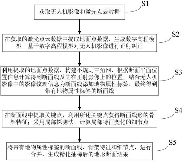
[0045] Such as figure 1 As shown, an embodiment of an aspect of the present invention provides a method for making a terrain section that fuses UAV images and laser point clouds, including the following steps:

[0046] S1. Obtain UAV images and laser point cloud data; it should be noted that it also includes precise image external orientation elements and camera internal parameters;

[0047] S2. Extract ground point data from the acquired laser point cloud data, generate a digital elevation model, and perform orthorectification on the UAV image based on the digital elevation model;

[0048] S3. Use the extracted ground point data to construct an irregular triangulation network, and use the irregular triangulation network to calculate the section line and its position on the orthophoto according to the input section plane position information, co...


PUM


Abstract

The invention discloses a method for making terrain sections by fusing UAV images and laser point clouds, including obtaining UAV images and laser point cloud data; Section lines with feature attribute labels; extracting skeleton features and detail points; merging section lines, skeleton features and detail points with feature attribute labels to generate refined and thinned topographic section results and other steps. Combined use of laser point cloud and UAV images for ground line production effectively avoids the drawbacks of a single data source. It is not only suitable for the production of high-precision section lines in complex areas, but also can obtain the attribute point information of roads, houses and other ground objects, thus meeting various needs of engineering survey and topographic surveying and mapping.

Description

technical field [0001] The invention relates to the technical field of UAV surveying and mapping, in particular to a method for making terrain sections by fusing UAV images and laser point clouds. Background technique [0002] Topographic section is a very important topographic feature information, which can reflect the elevation fluctuation of a local area in the direction of a certain plane line, and can also visually show the topographic type and characteristics of an area. Therefore, topographic sections are widely used in engineering survey and construction of railways and highways, as well as land surveying and mapping. The traditional method of obtaining terrain sections is that operators use total stations, GPS / RTK and other instruments and equipment to collect terrain point coordinates in the target area, and then calculate and draw the section vector diagram in the office. However, in actual projects, due to the complex terrain environment of the survey area (such...

Claims


Application Information

Patent Timeline
03 May 2022
Publication
CN114283070B
IPC
G06T3/40; G06T5/30; G06T7/73; G06T17/20
Inventors
王广帅; 邓继伟