Landslide disaster emergency monitoring method based on ground-based radar

A ground-based radar and disaster technology, applied in measurement devices, radio wave measurement systems, radio wave reflection/re-radiation, etc., to facilitate reception and transmission, improve emergency efficiency, and improve installation efficiency.

Pending Publication Date: 2022-04-22
NORTHWEST UNIV(CN)
View PDF0 Cites 2 Cited by
  • Summary
  • Abstract
  • Description
  • Claims
  • Application Information

AI Technical Summary

Problems solved by technology

[0006] The purpose of the present invention is to solve the problem that the landslide disaster emergency monitoring method in the prior art is relatively simple, and it is impossible to remotely monitor the landslide in the observation area and control and adjust the monitoring equipment, and propose a landslide disaster emergency monitoring based on ground-based radar method

Method used


Image

  • Landslide disaster emergency monitoring method based on ground-based radar
  • Landslide disaster emergency monitoring method based on ground-based radar
  • Landslide disaster emergency monitoring method based on ground-based radar

Examples


Embodiment 1

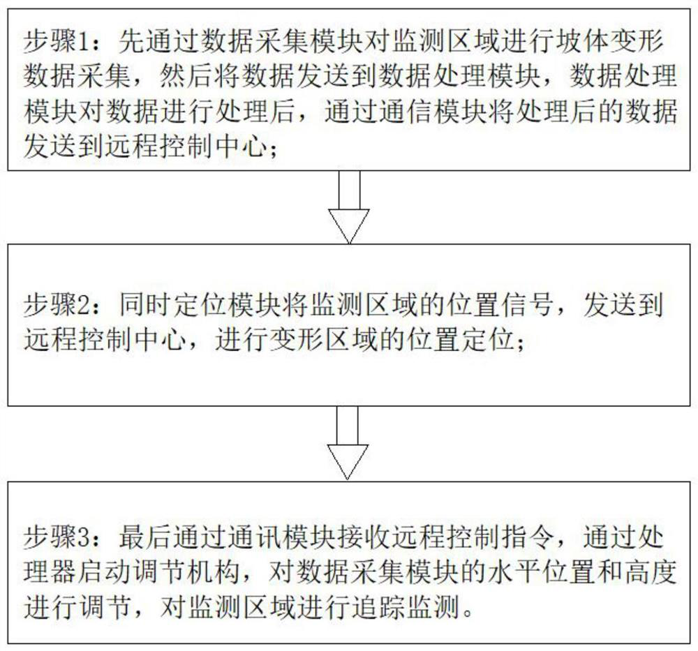
[0037] refer to figure 1 , a landslide disaster emergency monitoring method based on ground-based radar, comprising the following steps:

[0038] Step 1: first collect slope deformation data in the monitoring area through the data acquisition module, and then send the data to the data processing module. After the data processing module processes the data, it sends the processed data to the remote control center through the communication module;

[0039] Step 2: At the same time, the positioning module sends the position signal of the monitoring area to the remote control center to locate the deformation area;

[0040] Step 3: Finally, receive the remote control command through the communication module, start the adjustment mechanism through the processor, adjust the horizontal position and height of the data acquisition module, and track and monitor the monitoring area.

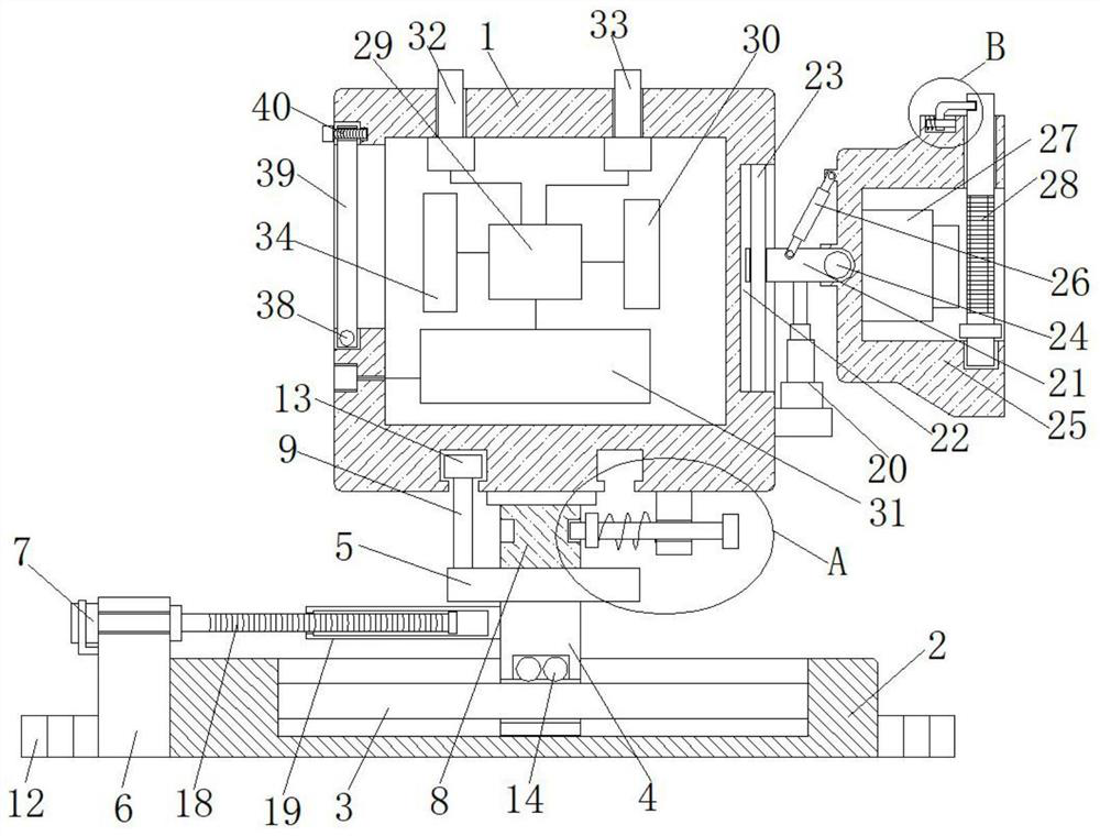
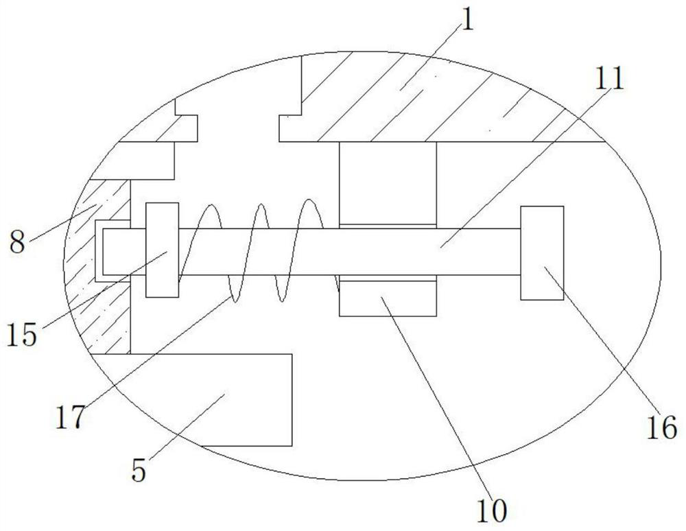
[0041] In this example, refer to Figure 2-5 , the adjustment mechanism includes a control box 1 and a m...


PUM


Abstract

The invention discloses a landslide disaster emergency monitoring method based on a ground-based radar, and the method comprises the following steps: 1, carrying out the slope deformation data collection of a monitoring region through a data collection module, transmitting the data to a data processing module, processing the data through the data processing module, and transmitting the processed data to a cloud server; the processed data is sent to a remote control center through the communication module; 2, a positioning module sends a position signal of the monitoring area to a remote control center, and position positioning of the deformation area is carried out; and step 3, finally, receiving a remote control instruction through a communication module, starting an adjusting mechanism through a processor, adjusting the horizontal position and height of the data acquisition module, and tracking and monitoring the monitoring area. According to the invention, through the arrangement of the remote monitoring module and the remote control method, deformation area positioning can be rapidly and accurately carried out on the landslide monitoring area, so that the emergency efficiency of landslide disasters is improved.

Description

technical field [0001] The invention relates to the technical field of landslide disaster monitoring, in particular to an emergency monitoring method for landslide disasters based on ground-based radar. Background technique [0002] Landslide monitoring mainly includes total station, global navigation satellite system (GNSS), unmanned aerial vehicle photogrammetry, 3D laser scanning measurement and optical remote sensing measurement, etc. Although the total station and the global navigation satellite system (GNSS) can obtain high-precision landslide point information, they cannot obtain the deformation results of the entire landslide area and cannot conduct large-scale observations. Although 3D laser scanning measurement, UAV photogrammetry and optical remote sensing measurement have high observation accuracy and wide observation range, they are obviously affected by the weather. For example, it is difficult to obtain accurate results under weather conditions such as rain, s...

Claims


Application Information

Patent Timeline
Patent Type & Authority Applications(China)
IPC IPC(8): G01S13/88G01S7/02F16M11/04F16M11/10F16M11/18F16M11/20
CPCG01S13/885G01S7/02F16M11/2085F16M11/2014F16M11/046F16M11/10F16M11/18
Inventor 邱海军朱亚茹杨冬冬裴艳茜
Owner NORTHWEST UNIV(CN)
Why Eureka
Try Eureka