Method and system for matching ground elements between multiple batches of relative maps

A matching method and map technology, applied in the generation of 2D images, extraction of basic elements, image analysis, etc., can solve the problems that the results cannot always conform to the actual environment, and it is difficult to obtain reliable and stable results, so as to facilitate online operation, Reduce the intervention of complex rules and use sufficient effects

Pending Publication Date: 2022-05-13
WUHAN ZHONGHAITING DATA TECH CO LTD
View PDF0 Cites 0 Cited by
  • Summary
  • Abstract
  • Description
  • Claims
  • Application Information

AI Technical Summary

Problems solved by technology

[0004] The absolute accuracy of relative maps based on low-precision GPS is generally within 10 meters. In the process of multi-batch relative map fusion, the matching process of ground elements is the most critical. When the ground elements of different batches of maps can be correctly matched and correlated, The subsequent optimization can only be continued, and the matching method of ground elements is often difficult to obtain reliable and stable results due to the environment of the collected data, changes in data quality and accuracy
[0005] Conventional different batches of ground feature matching methods include image semantic descriptor matching in SLAM, but in actual situations, the descriptor extraction methods of these methods are mostly obtained from experience, and the results cannot always match the actual environment

Method used


Image

  • Method and system for matching ground elements between multiple batches of relative maps
  • Method and system for matching ground elements between multiple batches of relative maps
  • Method and system for matching ground elements between multiple batches of relative maps

Examples


Embodiment 1

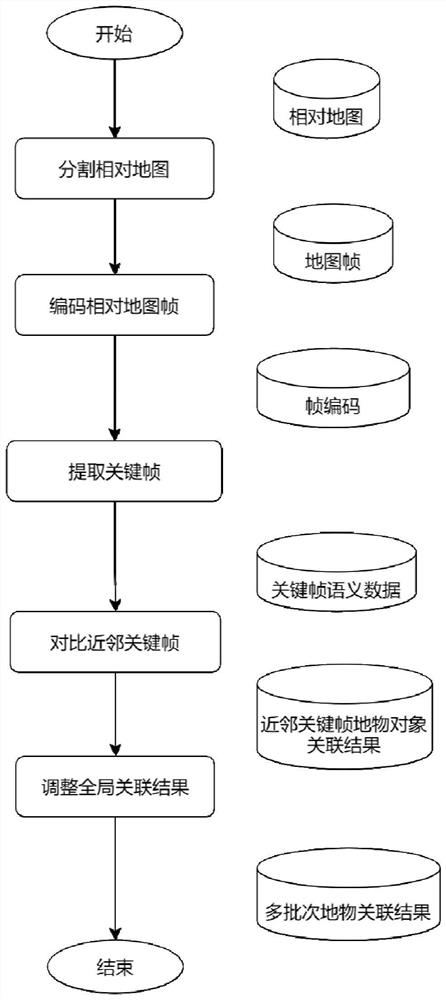
[0051] Embodiment 1 provided by the present invention is an embodiment of a method for matching ground elements between multiple batches of relative maps provided by the present invention, combining figure 1 As can be seen, embodiments of the matching method include:

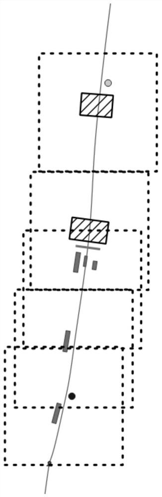
[0052] Step 1: Select the map frame and its key points relative to the map, divide each map frame around the key point, and output the frame range of the map frame.

[0053] In a possible embodiment, the process of selecting the map frame and key points of the relative map in step 1 includes:

[0054] Along the track direction of the relative map, select the key points of the track according to the set distance interval, and use the key point as the center to establish the frame range of the set size area.

[0055] The size area is set to be a square, and the range of the side length of the square is 40±5 meters.

[0056] In a specific implementation, the set distance interval may be 20 meters, and the square ...

Embodiment 2

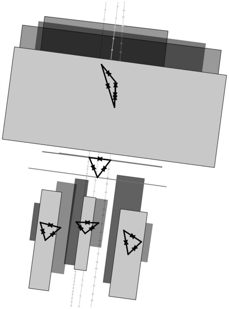
[0093] Embodiment 2 provided by the present invention is an embodiment of a matching system of ground elements between multiple batches of relative maps provided by the present invention, Figure 4 A structural diagram of a matching system for ground elements between multiple batches of relative maps provided by an embodiment of the present invention, combined with Figure 4It can be seen that the embodiment of the matching system includes: a frame range output module, a key frame acquisition module and an association result output module.

[0094] The frame range output module is used to select the map frame and its key points relative to the map, divide each map frame with the key point as the center, and output the frame range of the map frame.

[0095] The key frame acquisition module is used to obtain the types and corresponding quantities of feature objects with reliable positions in the feature objects included in the frame range, and determine the key frames in the map...


PUM


Abstract

The invention relates to a matching method and system for ground elements between multiple batches of relative maps, and the matching method comprises the steps: selecting map frames of the relative maps and key points of the map frames, segmenting each map frame by taking the key points as the center, and outputting the frame range of the map frames; obtaining the types and the corresponding number of ground objects with reliable positions in the ground object objects contained in the frame range, and determining key frames in the map frame according to the types and the corresponding number of the contained ground objects; comparing the ground object to match the neighbor key frames, and outputting an association relationship of the neighbor key frames; after the global association result is adjusted, outputting a ground feature association result; matching is carried out based on semantic elements, data error tolerance is higher, an actual production environment is better met, and the method is easy to debug, convenient to control, good in interpretation, high in robustness, capable of directly expressing data features and suitable for being used in a real environment of large-scale data.

Description

technical field [0001] The invention relates to the field of high-precision map production, in particular to a method and system for matching ground elements between multiple batches of relative maps. Background technique [0002] In the field of high-precision map production, it often involves the fusion of multiple batches of relative maps. The relative map refers to the local map constructed by the camera and IMU (inertial measurement unit) when the bicycle is moving, and is registered to the absolute position through the low-precision GPS reference. The absolute accuracy of the ground object is about 1-10m. The relative map of a single batch refers to the result of a single run of a bicycle. The multi-batch relative map refers to the result of multi-vehicle running for multiple times, which is actually multiple single-batch relative maps. [0003] The matching of ground objects between multiple batches of relative maps is to estimate which objects of different batches ...

Claims


Application Information

Patent Timeline
Patent Type & Authority Applications(China)
IPC IPC(8): G06T11/20G06T7/11G06T7/73G06T9/00G06K9/62G06V10/75
CPCG06T11/206G06T7/11G06T7/74G06T9/00
Inventor 石涤文尹玉成覃飞杨胡丹丹刘奋
Owner WUHAN ZHONGHAITING DATA TECH CO LTD
Why Eureka
Try Eureka