Method and system for realizing image mass production function

An image map and mass production technology, applied in the field of artificial intelligence, can solve problems such as the inability to guarantee the accuracy of the map, affect the timeliness of the map, and slow speed, so as to improve the intelligence of the map, improve the efficiency and accuracy of the map rate and improve the scope of application

Pending Publication Date: 2022-05-20
刘青
View PDF0 Cites 0 Cited by
  • Summary
  • Abstract
  • Description
  • Claims
  • Application Information

AI Technical Summary

Problems solved by technology

[0004] The purpose of the present invention is to provide a method and system for realizing the mass production function of image maps, which is used to solve the problems in the prior art by referring to relevant drawing standards and requirements to manually make maps and manually input relevant map elements when printing. There are technical problems such as slow speed, low efficiency, affecting the timeliness of drawings, and the accuracy of drawings cannot be guaranteed

Method used


Image

  • Method and system for realizing image mass production function
  • Method and system for realizing image mass production function
  • Method and system for realizing image mass production function

Examples


Embodiment 1

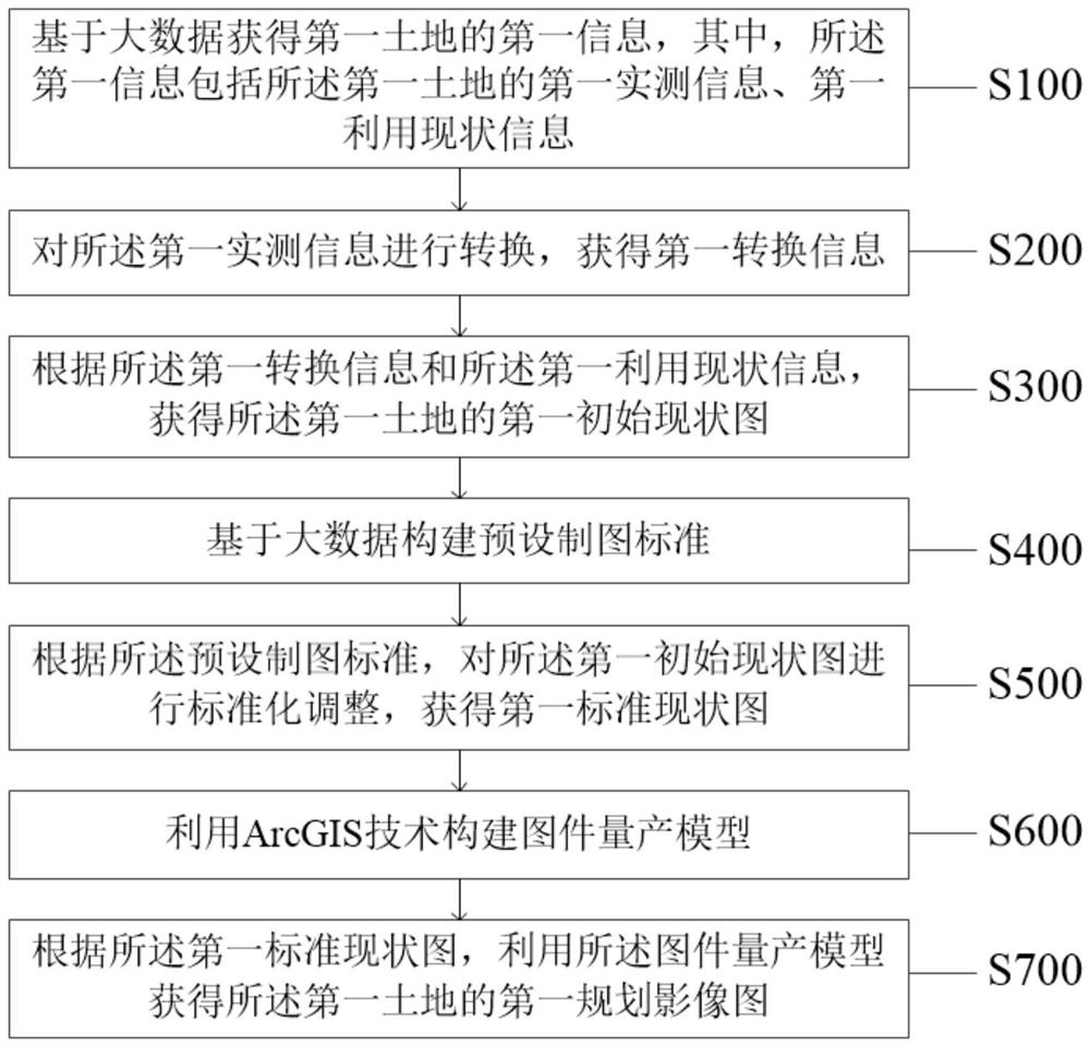
[0035] Please refer to the attached figure 1 , the present invention provides a method for realizing the mass production function of image maps, wherein the method is applied to a system for realizing the mass production function of image maps, and the method specifically includes the following steps:

[0036] Step S100: Obtain first information of the first land based on big data, wherein the first information includes first measured information and first utilization status information of the first land;

[0037] Specifically, the method for realizing the mass production function of image maps is applied to the system for realizing the mass production functions of image maps, and the mass production model of maps can be constructed through ArcGIS technology, so as to realize the increase of various types of urban and rural construction land. Reduce the intelligent production of linked project drawings, that is, realize the mass production of image drawings. Wherein, the image ...

Embodiment 2

[0095] Based on the same inventive concept as the method for realizing the mass production function of image images in the foregoing embodiments, the present invention also provides a system for realizing the mass production function of image images, please refer to the attached Figure 5 , the system includes:

[0096] The first obtaining unit 11, the first obtaining unit 11 is used to obtain the first information of the first land based on big data, wherein the first information includes the first measured information of the first land, the first utilization status information;

[0097] A second obtaining unit 12, the second obtaining unit 12 is configured to convert the first measured information to obtain first converted information;

[0098] A third obtaining unit 13, the third obtaining unit 13 is configured to obtain a first initial current situation map of the first land according to the first conversion information and the first current utilization information;

[0...


PUM


Abstract

The invention discloses a method and system for realizing an image mass production function, and the method comprises the steps: obtaining the first information of a first land based on big data, and enabling the first information to comprise the first actual measurement information and the first utilization current information of the first land; converting the first actual measurement information to obtain first conversion information; obtaining a first initial current situation map of the first land according to the first conversion information and the first utilization current situation information; constructing a preset drawing standard; obtaining a first standard current situation graph according to the preset drawing standard; constructing a map mass production model by utilizing an ArcGIS technology; and obtaining a first planning image map of the first land. The technical problems that in the prior art, the speed is low, the efficiency is low, the timeliness of the map is affected and the accuracy rate of the map cannot be guaranteed due to the fact that the map is manually manufactured by referring to related drawing standards and requirements, and related map elements are manually input during printing are solved.

Description

technical field [0001] The invention relates to the field of artificial intelligence, in particular to a method and system for realizing the mass production function of images. Background technique [0002] In order to promote the construction of new countryside and improve the rationality of land use layout, relevant departments, according to the overall plan of national land use, comprehensively renovate the inefficiently used construction land in rural areas and increase the area of ​​cultivated land, so as to realize the increase of urban construction land and the decrease of rural construction land The goal of linking with each other and maintaining a balance in the total amount of construction land. Among them, the newly-increased farmland in rural areas and the newly-increased construction land in cities together constitute the project area for the construction, demolition and old demolition. During the implementation of new construction and demolition projects, it i...

Claims


Application Information

Patent Timeline
Patent Type & Authority Applications(China)
IPC IPC(8): G06F16/29
CPCG06F16/29
Inventor 刘青夏杰郭卓利
Owner 刘青
Why Eureka
Try Eureka