Three-dimensional stratum modeling method based on drilling data

A technology of borehole data and three-dimensional stratigraphy, applied in the field of computer science visualization, can solve the problems of low model accuracy, uneven spatial distribution, insufficient control of spatial morphological characteristics of complex geological bodies, etc., and achieve high precision.

Pending Publication Date: 2022-05-27
ANHUI UNIV OF SCI & TECH
View PDF0 Cites 1 Cited by
  • Summary
  • Abstract
  • Description
  • Claims
  • Application Information

AI Technical Summary

Problems solved by technology

[0003] The application of borehole data modeling is a common method for 3D geological modeling. However, due to construction conditions, drilling costs and other reasons, the existing borehole data modeling methods can obtain limited borehole data, and the spatial distribution is relatively large. Sparse and uneven, resulting in insufficient control of the spatial morphological characteristics of complex geological bodies during modeling, and the accuracy of the established model is not high; therefore, a 3D stratigraphic modeling method based on borehole data is proposed now, using interpolation to obtain drill Borehole data, on the basis of the existing geological data, add some borehole data at key positions according to the geological laws and distribution characteristics of geological bodies to make up for the lack of data, which can realize effective control of geological bodies and rapid construction of models, and achieve The purpose of improving model accuracy

Method used


Image

  • Three-dimensional stratum modeling method based on drilling data

Examples


Embodiment Construction

[0019] The technical solutions in the embodiments of the present invention will be clearly and completely described below with reference to the accompanying drawings in the embodiments of the present invention. Obviously, the described embodiments are only a part of the embodiments of the present invention, rather than all the embodiments. Based on the embodiments of the present invention, all other embodiments obtained by those of ordinary skill in the art without creative efforts shall fall within the protection scope of the present invention.

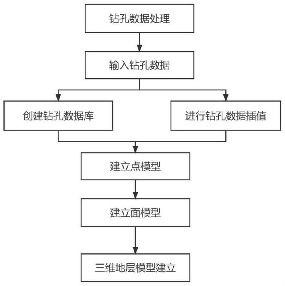
[0020] like figure 1 As shown, a 3D stratigraphic modeling method based on borehole data, the method includes the following steps:

[0021] Step 1: Count the original drilling data in the modeling area, and get an Excel table about the drilling number, sounding, coordinate data and layering information;

[0022] It should be further explained that, in the specific implementation process, the drill hole number (WellName), sounding (M...


PUM


Abstract

The invention discloses a three-dimensional stratum modeling method based on drilling data, and belongs to the field of computer science visualization, and the method comprises the steps: carrying out the statistics of original drilling data in a modeling region through the processing of the drilling data, and obtaining a table related to the drilling number, sounding depth, coordinate data and layering information; establishing a point model reading table, establishing a drilling database, and constructing hierarchical point model data according to drilling information; kriging interpolation is carried out, a layered point data model is exported for Kriging interpolation, virtual drilling data of each layer is obtained and imported into a drilling database, and the established point model is updated; surface models are established, each layer model is established according to the drilling data, and the curved surface is edited according to the contact condition of the control points and the curved surface; the method comprises the following steps: establishing a three-dimensional stratum model, selecting a modeling area, selecting all stratums to construct stratum columns, establishing a stratum plane, adjusting the stratum plane according to an actual profile map and the like, establishing a geological grid, and finally generating the three-dimensional stratum model.

Description

technical field [0001] The invention relates to the technical field of computer science visualization, in particular to a three-dimensional formation modeling method based on borehole data. Background technique [0002] 3D geological model expresses complex geological structure and geological body shape in 3D form. With the support of GIS technology and computer technology, 3D geological modeling has been developed rapidly, and it has been effectively applied to engineering geology, oil and gas development, and geological disaster management. , geophysical exploration and other fields, have researched a variety of three-dimensional data models and modeling methods suitable for different engineering geological environments in different fields. [0003] Application of borehole data modeling is a common method for 3D geological modeling, but due to construction conditions, drilling costs and other reasons, the existing borehole data modeling methods can obtain borehole data oft...

Claims


Application Information

Patent Timeline
Patent Type & Authority Applications(China)
IPC IPC(8): G06T17/05
CPCG06T17/05
Inventor 李慧颖张丽雯陈小艳宋涛
Owner ANHUI UNIV OF SCI & TECH
Why Eureka
Try Eureka