Unmanned aerial vehicle inspection path planning method based on discrete point density and global planning

A technology of inspection path and global planning, applied in mechanical equipment, combustion engines, internal combustion piston engines, etc., can solve the problems of many inspection points, long intervals of inspection points, and difficulty in completing inspection tasks, reducing the number of inspection points. Energy consumption, low cost, finely measured effect

Pending Publication Date: 2022-06-03
EAST CHINA NORMAL UNIV
View PDF0 Cites 2 Cited by
  • Summary
  • Abstract
  • Description
  • Claims
  • Application Information

AI Technical Summary

Problems solved by technology

Using UAVs for road inspections will have the following main challenges: 1) The points to be inspected are far apart, and there are many points that need to be inspected. It is difficult for a UAV to complete the inspection task

Method used


Image

  • Unmanned aerial vehicle inspection path planning method based on discrete point density and global planning
  • Unmanned aerial vehicle inspection path planning method based on discrete point density and global planning
  • Unmanned aerial vehicle inspection path planning method based on discrete point density and global planning

Examples


Embodiment

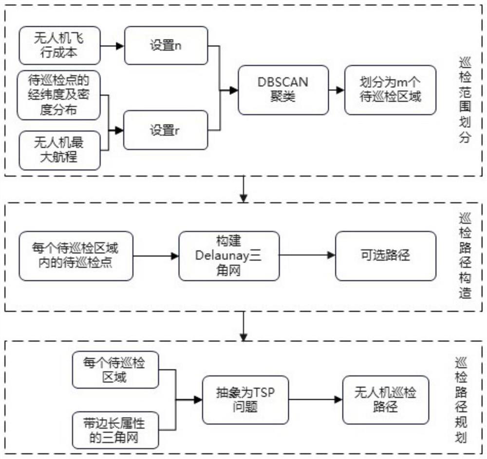
[0020] The specific process of this embodiment includes three steps:

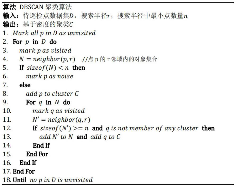
Step 1: Refer to Figure 5 , there are 19 points to be inspected in the entire area to be inspected, and the longitude and latitude of each point to be inspected are obtained respectively. In order to meet the cost of a single flight of the UAV, set n to 3; comprehensively consider the shortest distance between the points to be inspected and the maximum range of the UAV, observe the spatial position and density relationship of the inspection points, and the radius is 2 kilometers. There are 3 or more points to be inspected in the range, which is more in line with the density distribution of the points to be inspected, so set the search radius r to 2 kilometers. see figure 2 , using the DBSCAN algorithm to cluster the inspection points, the algorithm will visit a point arbitrarily, and find all points with a distance of less than or equal to 2 kilometers from the point, if the number of points in its neigh...


PUM


Abstract

The invention discloses an unmanned aerial vehicle routing inspection path planning method based on discrete point density and global planning, which comprises the following steps: (1) routing inspection range division: firstly, clustering by using a DBSCAN clustering algorithm according to the spatial position and density relationship of discrete to-be-inspected points, dividing the to-be-inspected points in the space into m to-be-inspected areas, m unmanned aerial vehicles are dispatched to be responsible for patrolling of to-be-patrolled points in all areas; (2) routing inspection path construction: aiming at each to-be-inspected area, constructing a Delaunay triangulation network for to-be-inspected points in the area, networking discrete points, and taking each edge of the triangulation network as an optional routing inspection path of the unmanned aerial vehicle; and (3) routing inspection path planning: planning of the routing inspection path of the unmanned aerial vehicle in each to-be-inspected area can be abstracted as a Traveling SalesmanProblem problem, that is, the unmanned aerial vehicle starts from a certain to-be-inspected point, takes each edge in the triangulation network as a selectable path, traverses all to-be-inspected points in the to-be-inspected area, does not repeatedly pass through the same to-be-inspected point, and enables the total path to be shortest.

Description

technical field [0002] The invention belongs to the technical field of path optimization, and in particular relates to a UAV inspection path planning method based on discrete point density and global planning. Background technique [0003] With the continuous increase in the speed of economic and social development in my country, urban construction has been carried out steadily. The coordinated development of urban economy depends on the planning of urban roads. Therefore, road construction has become a crucial aspect of urban construction. The performance and status of road facilities are directly related to urban traffic safety and travel experience. In the management and maintenance of urban roads, road inspection is a key link in the improvement of urban road facilities. The information of road inspection can be used in fields such as screening road disease information, abnormal vehicle detention, and intersection environment monitoring. Road monitoring is not a one-ti...

Claims


Application Information

Patent Timeline
Patent Type & Authority Applications(China)
IPC IPC(8): G05D1/10
CPCG05D1/106Y02T10/40
Inventor 孟焕李响
Owner EAST CHINA NORMAL UNIV
Why Eureka
Try Eureka