Method for dynamically adjusting navigation path of unmanned aerial vehicle in real time

A navigation path, real-time dynamic technology, applied in the field of UAV navigation, can solve the problems such as the lack of general aviation traffic control standards and plans, the limitation of the market application scale of UAV technology, and the limited application area, so as to improve the real-time performance and accuracy, strong path optimization, and the effect of optimizing the flight path

Pending Publication Date: 2021-11-09
武夷科技信息(北京)有限公司
View PDF0 Cites 1 Cited by
  • Summary
  • Abstract
  • Description
  • Claims
  • Application Information

AI Technical Summary

Problems solved by technology

However, it is difficult to promote UAV transportation technology nationwide, and its application area is limited. The main reason is that it has not formulated a unified general aviation traffic control standard and plan for UAVs, and there is a lack of standardized routes and routes between waypoints. Planning theory, lack of obstacle avoidance technology, etc., limit the market application scale of UAV technology

Method used


Image

  • Method for dynamically adjusting navigation path of unmanned aerial vehicle in real time
  • Method for dynamically adjusting navigation path of unmanned aerial vehicle in real time
  • Method for dynamically adjusting navigation path of unmanned aerial vehicle in real time

Examples


Embodiment 1

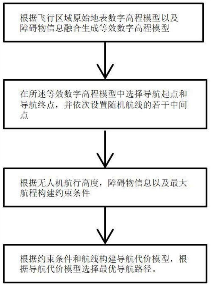
[0028] The UAV real-time dynamic adjustment navigation path method includes: S1, according to the original surface digital elevation model of the flight area and the fusion of obstacle information to generate an equivalent digital elevation model;

[0029] S2, selecting a navigation starting point and a navigation end point in the equivalent digital elevation model, and sequentially setting several intermediate points of random routes;

[0030] S3, constructing constraint conditions according to the flight height of the drone, the obstacle information and the maximum range;

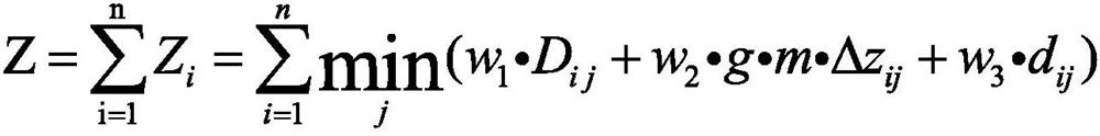
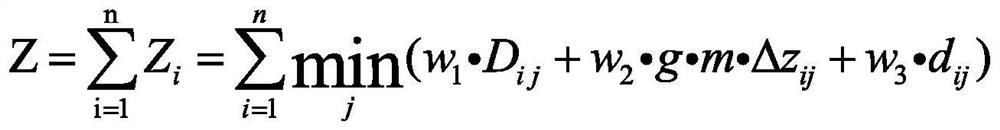
[0031] S4. Construct a navigation cost model according to constraints and routes, and select an optimal navigation path according to the navigation cost model.

[0032] Further, the constraints also include horizontal rotation angle, pitch angle, the minimum step size of the route, and the safe distance of the waypoint.

[0033] Further, before step S1, the UAV receives the no-fly zone and extreme weathe...

Embodiment 2

[0044] The method of real-time dynamic adjustment of the navigation path of the UAV includes:

[0045] S0, the UAV receives the no-fly zone and extreme weather information sent by the server in real time,

[0046] S1, generate an equivalent digital elevation model based on the fusion of the original surface digital elevation model and obstacle information in the flight area;

[0047] S11, periodically merging the navigation no-fly zone and extreme weather information sent by the UAV real-time receiving server into the equivalent digital elevation model to generate an optimized equivalent digital elevation model;

[0048] S2, selecting a navigation start point and a navigation end point in the equivalent digital elevation model;

[0049] S3, constructing constraint conditions according to the flight height of the drone, the obstacle information and the maximum range;

[0050] S4, constructing a navigation cost model according to the constraints and routes, and selecting the o...


PUM


Abstract

The invention discloses a method for dynamically adjusting a navigation path of an unmanned aerial vehicle in real time. The method comprises the following steps: fusing an original earth surface digital elevation model and obstacle information in a flight area to generate an equivalent digital elevation model; selecting a navigation starting point and a navigation ending point in the equivalent digital elevation model, and sequentially setting a plurality of middle points of a random route; constructing constraint conditions according to the navigation height of the unmanned aerial vehicle, the obstacle information and the maximum voyage; and constructing a navigation cost model according to the constraint condition and the route, and selecting an optimal navigation path according to the navigation cost model, so that the flight flexibility and safety of the unmanned aerial vehicle can be effectively improved.

Description

technical field [0001] The invention belongs to the field of unmanned aerial vehicle navigation, and in particular relates to real-time dynamic adjustment of a navigation path by an unmanned aerial vehicle. Background technique [0002] At present, the development of drone technology is very fast, and some progress has been made in military and civilian applications, which mainly depends on the relative safety, high mobility, low cost and flexible operation of drones. However, it is difficult to promote UAV transportation technology nationwide, and its application area is limited. The main reason is that it has not formulated a unified general aviation traffic control standard and plan for UAVs, and there is a lack of standardized routes and routes between waypoints. Planning theory, lack of obstacle avoidance technology, etc., limit the market application scale of UAV technology. During the flight of the UAV, its flight path is generally calculated and fixed before the fli...

Claims


Application Information

Patent Timeline
Patent Type & Authority Applications(China)
IPC IPC(8): G01C21/20G01C21/16G01S19/45G01S19/47G05D1/10
CPCG01C21/20G01C21/165G01S19/45G01S19/47G05D1/101
Inventor 王佩李帅
Owner 武夷科技信息(北京)有限公司
Why Eureka
Try Eureka