High-resolution image and machine learning-based high-altitude region crop classification and identification method

A machine learning, classification and recognition technology, applied in character and pattern recognition, scene recognition, instruments, etc., can solve the problems that are rarely involved, and the advantages of domestic high-resolution image data classification and recognition are not clearly defined, so as to reduce the model complexity, improving the accuracy of crop classification and recognition, and improving the efficiency of model operation

Pending Publication Date: 2022-07-01
NANJING AGRICULTURAL UNIVERSITY +1
View PDF8 Cites 3 Cited by
  • Summary
  • Abstract
  • Description
  • Claims
  • Application Information

AI Technical Summary

Problems solved by technology
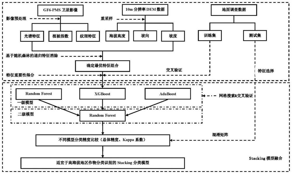
[0007] Existing research on crop identification is mostly concentrated in plain areas, and research on crop classification and identification in high-altitude areas is rarely involved; and the advantages of domestic high-resolution image data in crop classification and identification in high-altitude areas have not yet been clarified. The classification effect of the Stacking model in high-altitude areas still needs further research

Method used


Image

  • High-resolution image and machine learning-based high-altitude region crop classification and identification method
  • High-resolution image and machine learning-based high-altitude region crop classification and identification method
  • High-resolution image and machine learning-based high-altitude region crop classification and identification method

Examples


Embodiment 1

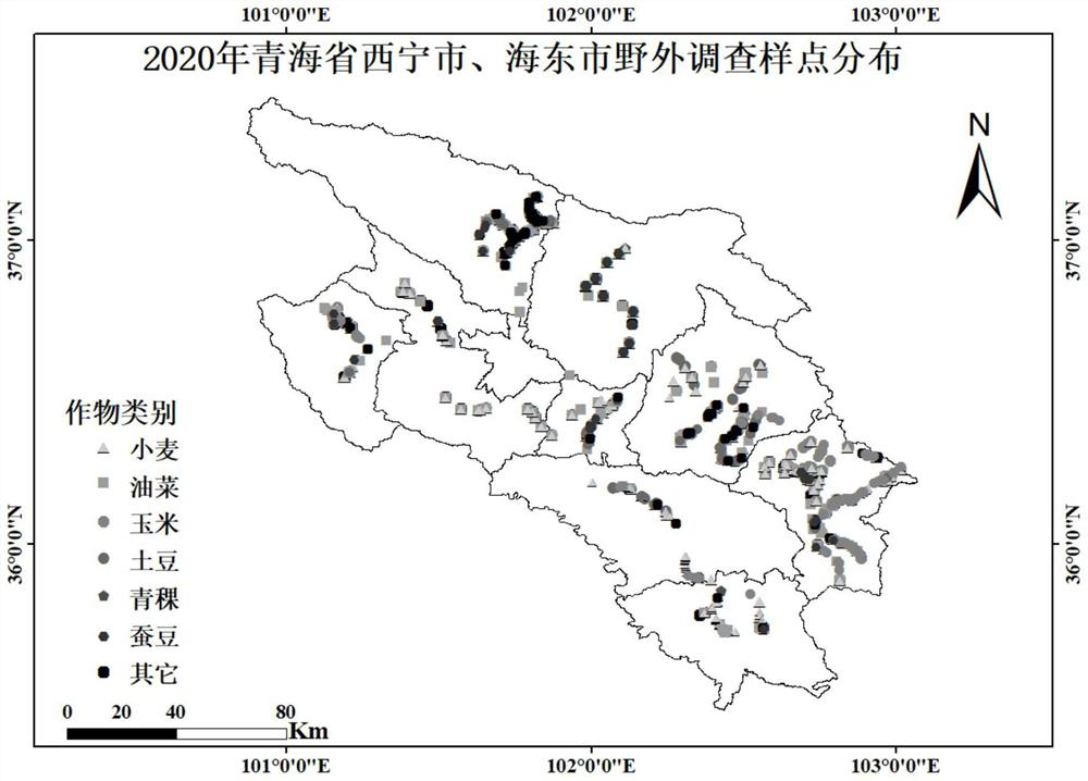
[0077] This example is based on the field survey data of Xining City and Haidong City in Qinghai Province in 2020 and the corresponding GF6-PMS image data, as shown in Table 1 and Table 2:

[0078] Table 1. Number of training samples and validation samples (in POI, number of pixels)

[0079]

[0080]

[0081] Table 2. GF6-PMS satellite image parameters

[0082]

[0083] Two field surveys were conducted in Xining City and Haidong City, Qinghai Province from June to July 2020. The ground survey data followed the principle of random and even distribution in each township. The ground sample points were divided into wheat, rapeseed, corn, potato, For highland barley, broad beans, and other seven categories, 70% of the survey data is divided into training set, and 30% of survey data is divided into validation set.

[0084] The remote sensing data used are from July-August 2020 with less cloud cover and the eight-view GF-6PMS satellite images covering Xining City and Haidon...


PUM


Abstract

The invention discloses a high-resolution image and machine learning-based high-altitude region crop classification and identification method, which comprises the following steps of: screening out an optimal feature combination through a recursive feature elimination strategy based on a random forest by using a domestic GF6-PMS satellite image and combining features such as spectrum, texture, vegetation index and topographic factor; and calculating a Gini index to obtain an importance score of each input feature, and further utilizing a two-layer stack-driven integrated classification model (including three single classifier models of Random Forest, XGBoost and AdaBoost) to classify and identify the crops in the high-altitude region. The Stacking model constructed on the basis of the optimal feature combination (Green, Red, NIR, TVI, GNDVI, BlueMean, GreenMean, RedMean, NIRMean, DEM) can improve the classification and recognition precision of crops in high-altitude areas to a large extent, especially the classification and recognition precision of bulk crops with large planting areas, and provides a scientific reference basis for crop remote sensing recognition of domestic high-resolution satellite images in high-altitude areas.

Description

technical field [0001] The invention relates to the field of dynamic monitoring of cultivated land changes in high-altitude areas based on domestic high-resolution satellite images, in particular to a method for classifying and identifying crops in high-altitude areas based on high-resolution images and machine learning. Background technique [0002] Continued growth in the global population is increasing the risk of food shortages, and the world is facing ongoing food security challenges. With the continuous reduction of cultivated land area brought about by the increase of my country's population, my country's agricultural production has been accelerated to the direction of intensification and precision. With this shift in agricultural production patterns, there is a need to monitor agricultural systems more effectively, providing detailed spatial information about crop types in a timely and accurate manner. Obtaining key information such as crop spatial distribution, gro...

Claims


Application Information

Patent Timeline
Patent Type & Authority Applications(China)
IPC IPC(8): G06V20/13G06V10/764G06V10/54G06V10/40G06V10/58G06K9/62
CPCG06F18/24323
Inventor 姚霞马志远李伟朱艳程涛曹卫星马吉锋张小虎李红英张朝坤欧尔格力王苑郑恒彪
Owner NANJING AGRICULTURAL UNIVERSITY
Why Eureka
Try Eureka