Underwater terrain matching and positioning method and system of three-dimensional imaging sonar point cloud

An underwater terrain matching and three-dimensional imaging technology, which is applied in the re-radiation of sound waves, neural learning methods, radio wave measurement systems, etc., can solve the problems of low robustness, low positioning accuracy, and large amount of data. Small error, reduce precise positioning, improve the effect of matching effect

Pending Publication Date: 2022-07-05
NAT UNIV OF DEFENSE TECH
View PDF0 Cites 2 Cited by
  • Summary
  • Abstract
  • Description
  • Claims
  • Application Information

AI Technical Summary

Problems solved by technology

The most representative one is the terrain profile matching system. When this method is executed, it needs to measure a certain length of terrain elevation data along the track, and calculate its correlation with the reference data to obtain the position estimation of the carrier. This method requires the carrier to be in the In the process of meas

Method used


Image

  • Underwater terrain matching and positioning method and system of three-dimensional imaging sonar point cloud
  • Underwater terrain matching and positioning method and system of three-dimensional imaging sonar point cloud
  • Underwater terrain matching and positioning method and system of three-dimensional imaging sonar point cloud

Examples


Example Embodiment

[0045] The preferred embodiments of the present invention will be described in detail below with reference to the accompanying drawings, so that the advantages and features of the present invention can be more easily understood by those skilled in the art, and the protection scope of the present invention can be more clearly defined.

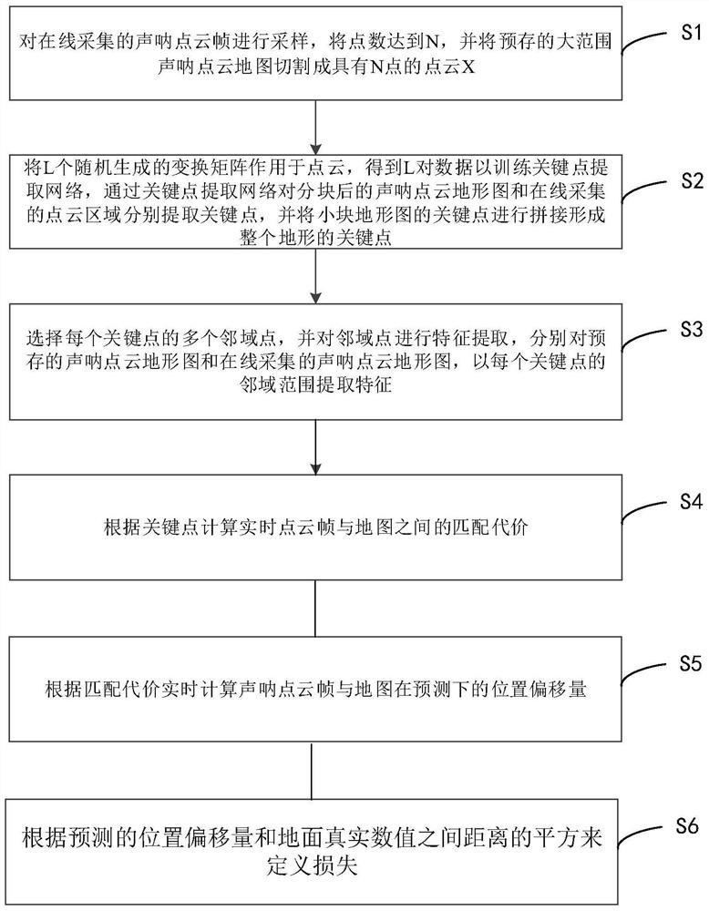
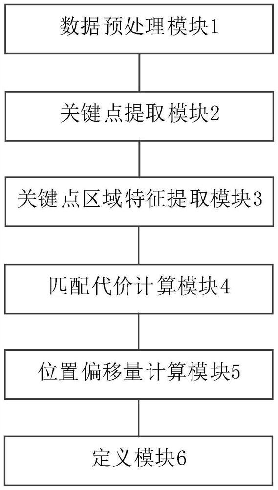
[0046] see figure 1 As shown, this embodiment discloses an underwater terrain matching and positioning method for a three-dimensional imaging sonar point cloud, which includes the following steps:

[0047] Step S1, sampling the sonar point cloud frame collected online, the number of points reaches N, and cutting the pre-stored large-scale sonar point cloud map into a point cloud X with N points;

[0048] Step S2, convert L randomly generated transformation matrices {T 1 ,…,T L },T L ∈SE(3) acts on the point cloud X=[X 0 ,…,X N ]∈R 3×N , get L pairs of data To train the key point extraction network, the key points are extracted from the s...


PUM


Abstract

The invention discloses a three-dimensional imaging sonar point cloud underwater terrain matching and positioning method and system, and the method comprises the steps: S1, carrying out the sampling of online collected sonar point cloud frames, enabling the number of points to reach N, and cutting a pre-stored large-range sonar point cloud map into a point cloud X with N points; s2, enabling L randomly generated transformation matrixes {T1,..., TL} and TL < SE (3) to act on the point cloud X = [X0,..., XN] < R3 * N, and obtaining L pairs of data to train a key point extraction network; s3, a plurality of neighborhood points of each key point are selected, feature extraction is carried out on the neighborhood points, and features are extracted from a pre-stored sonar point cloud topographic map and a sonar point cloud topographic map collected online according to the neighborhood range of each key point; s4, calculating the matching cost between the real-time point cloud frame and the map according to the key points; s5, calculating the position offset of the sonar point cloud frame and the map under prediction in real time according to the matching cost; and S6, defining the loss according to the square of the distance between the predicted position offset and the ground real value. The matching effect can be improved, errors are reduced, and positioning is accurate.

Description

technical field [0001] The invention relates to the technical field of terrain positioning, and more particularly, to a method and system for underwater terrain matching and positioning of three-dimensional imaging sonar point clouds. Background technique [0002] Due to the limitation of underwater communication, AUV (autonomous underwater vehicle) needs to go up to receive satellite signals for position correction after long-term dormant voyage underwater, which increases time and energy consumption for AUVs for large diving depth and long-range missions. [0003] The traditional underwater terrain matching positioning algorithm obtains the position information of the carrier by measuring the real-time terrain elevation data under the moving path of the carrier and comparing it with the known digital terrain reference. The most representative of them is the terrain profile matching system. When this method is executed, it needs to measure a certain length of terrain elevat...

Claims


Application Information

Patent Timeline
IPC IPC(8): G01S15/89G06V10/46G06N3/04G06N3/08G06T3/40G06V10/75
CPCG01S15/89G06N3/08G06T3/4038G06T2200/32G06N3/045
Inventor 张阳彭新
Owner NAT UNIV OF DEFENSE TECH
Why Eureka
Try Eureka