Visualization system and method based on UE4 engine and Cesium framework
An engine and framework technology, applied in the field of visualization system based on UE4 engine and Cesium framework, can solve problems such as distortion, deformation, slow loading speed, etc., achieve powerful 3D rendering capabilities and spatial analysis capabilities, clear 3D visualization display, and data processing fast effect
- Summary
- Abstract
- Description
- Claims
- Application Information
AI Technical Summary
Problems solved by technology
Method used
Image


Examples
Embodiment 1
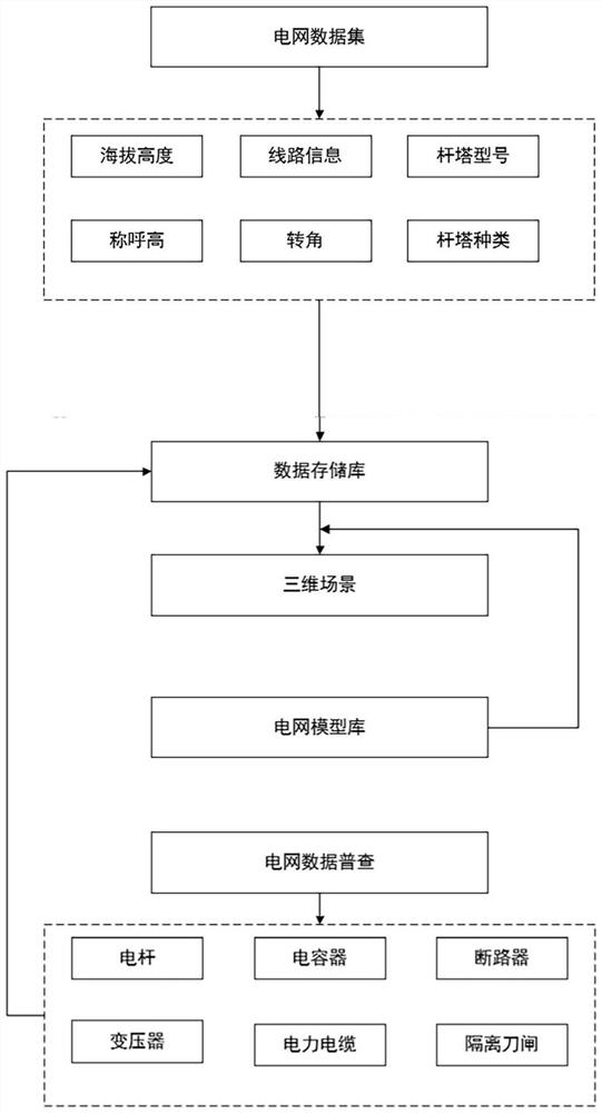
[0043] A visualization system based on UE4 engine and Cesium framework, such as Figure 1-Figure 5 As shown, including GIS data acquisition module, Cesium 3D earth model module and UE4 engine, Cesium 3D earth model module is embedded in the UE4 engine shown, GIS data is converted into the support coordinate system of the UE4 engine through the Cesium 3D earth model module, And use the UE4 engine to achieve a brilliant, high-definition 3D graphical interface for geographic coordinate visualization.
[0044] In this embodiment, GIS is an existing conventional geographic information system, which collects, stores, manages, calculates, analyzes, displays and describes relevant geographic distribution data in the entire or part of the earth's surface (including the atmosphere) space. The data is GIS data.
[0045] It should be further explained that the Cesium 3D earth model module includes a field rendering module, a tile map module, a latitude and longitude coordinate conversion...
Embodiment 2
[0092] A novel smart grid visualization method utilizing visualization systems such as figure 2 shown, including the following steps:
[0093] Step S101: Collect power grid-related data through a GIS system, and the collected data at least includes line length, tower type, tower position and horizontal rotation angle;
[0094] Step S102: integrating, classifying and cleaning the collected data, mainly integrating and classifying geographic location data, tower location data and tower model data, and cleaning unnecessary data;
[0095] Step S103: Store the geographic coordinates obtained from the integrated and classified data in the data model library in the data storage module, and import the data into the model library of the UE4 engine to search for the model; if the data model matches, the UE4 engine directly calls the data And directly transform to achieve 3D visualization; if the data model does not match, import the data into the Cesium 3D earth model module;
[0096...
PUM
 Abstract
Description
Claims
Application Information
 - R&D
- Intellectual Property
- Life Sciences
- Materials
- Tech Scout
- Unparalleled Data Quality
- Higher Quality Content
- 60% Fewer Hallucinations
Browse by: Latest US Patents, China's latest patents, Technical Efficacy Thesaurus, Application Domain, Technology Topic, Popular Technical Reports.
© 2025 PatSnap. All rights reserved.Legal|Privacy policy|Modern Slavery Act Transparency Statement|Sitemap|About US| Contact US: help@patsnap.com