
Remote sensing image conversion map migration method based on semi-supervised generative adversarial network

A remote sensing image, semi-supervised technology, applied in the field of data processing, which can solve the problems of blurred details, distortion of map elements, low geometric accuracy of maps and low visual quality.

Active Publication Date: 2022-07-26
NAT UNIV OF DEFENSE TECH
View PDF4 Cites 0 Cited by
  • Summary
  • Abstract
  • Description
  • Claims
  • Application Information

AI Technical Summary

Problems solved by technology

[0003] However, current GAN-based image-to-image techniques have some drawbacks in map generation
First, paired remote sensing images and map samples are relatively difficult to obtain. Due to the complex and long process of making remote sensing images to online maps, the map information released by online map services is relatively backward compared with timely updated remote sensing images.
On the other hand, map samples obtained by other methods may not have corresponding remote sensing images
However, in the absence of supervisory information constraints, only using unpaired samples may cause some problems, such as insufficient training, low accuracy of generated maps, etc. Second, some researchers use conditional generative adversarial network (cGAN) and L1 Distance learning maps functions from input to generated images, providing a usable framework for transforming remote sensing images into maps
However, only a simple loss function is used to constrain the model for map generation, and the training results often have problems such as map element distortion, geometric distortion, and blurred details.
The general image-to-image conversion model is not suitable for the task of generating remote sensing images to maps, and there are problems such as high pressure of data collection, low geometric accuracy and low visual quality of maps generated from remote sensing images

Method used


Image

  • Remote sensing image conversion map migration method based on semi-supervised generative adversarial network
  • Remote sensing image conversion map migration method based on semi-supervised generative adversarial network
  • Remote sensing image conversion map migration method based on semi-supervised generative adversarial network

Examples


Embodiment Construction

[0061] In order to make the purpose, technical solutions and advantages of the present application more clearly understood, the present application will be described in further detail below with reference to the accompanying drawings and embodiments. It should be understood that the specific embodiments described herein are only used to explain the present application, but not to limit the present application.

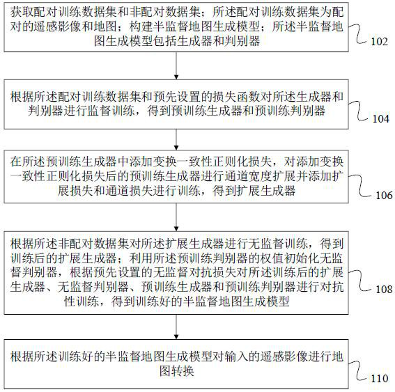
[0062] In one embodiment, as figure 1 As shown, a semi-supervised generative adversarial network-based remote sensing image conversion map transfer method is provided, which includes the following steps:

[0063] Step 102: Obtain paired training data sets and unpaired data sets; the paired training data sets are paired remote sensing images and maps; build a semi-supervised map generation model; the semi-supervised map generation model includes a generator and a discriminator.

[0064] The unpaired training dataset is unpaired remote sensing images and maps, and the s...


PUM


Abstract

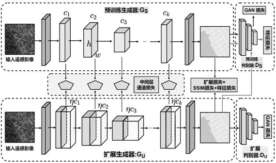
The invention relates to a remote sensing image conversion map migration method based on a semi-supervised generative adversarial network. The method comprises the following steps: constructing a semi-supervised map generation model; performing supervised training on a generator and a discriminator according to the paired training data set and a preset loss function, adding transformation consistency regularization loss in a pre-training generator, performing channel width expansion on the pre-training generator, and adding expansion loss and channel loss for training to obtain an expansion generator; and initializing an unsupervised discriminator by using the weight of the pre-training discriminator, performing adversarial training on the trained extension generator, the unsupervised discriminator, the pre-training generator and the pre-training discriminator according to preset unsupervised adversarial loss, and performing map conversion on an input remote sensing image according to a trained semi-supervised map generation model. By adopting the method, the geometric accuracy and visual quality of the map generated by the remote sensing image can be improved.

Description

technical field [0001] The present application relates to the technical field of data processing, and in particular, to a method, device, computer equipment and storage medium for remote sensing image conversion map migration based on semi-supervised generative adversarial network. Background technique [0002] With the rapid penetration of information technology and multimedia technology in the field of cartography, high-precision online map service has become an indispensable part of people's daily life. Due to the strong adaptability and low cost of remote sensing images, online map generation based on remote sensing images has been widely used. Before the rapid development of deep learning, traditional mapping methods required manual acquisition of vector data and then writing against mapping specifications, which was a very laborious job that required a lot of human involvement and expert experience. Due to the complicated and lengthy process of making maps from tradit...

Claims


Application Information

Patent Timeline
IPC IPC(8): G06T11/00G06N3/04G06N3/08
CPCG06T11/00G06N3/08G06N3/088G06N3/045Y02A10/40
Inventor 陈浩宋洁琼杜春熊伟彭双伍江江吴烨李军贾庆仁
Owner NAT UNIV OF DEFENSE TECH
Learn More