Unmanned aerial vehicle photogrammetry overlapping degree calculation method and system considering surface relief

A technology of photogrammetry and calculation method, which is applied in calculation, computer parts, and photo interpretation, etc. It can solve problems such as overlap errors, and achieve the effect of ensuring accuracy, stability, and reconstruction effect

Pending Publication Date: 2022-07-29
武汉大势智慧科技有限公司
View PDF0 Cites 0 Cited by
  • Summary
  • Abstract
  • Description
  • Claims
  • Application Information

AI Technical Summary

Problems solved by technology

[0005] In order to solve the problem of large errors in the overlap degree caused by the lack of consideration of the surface height change in the UAV photogrammetry technology, the first aspect of the present invention provides a method for calculating the overlap degree of UAV photogrammetry that takes into account the undulation of the ground surface , including: obtaining the pose and object elevation information of multiple images taken by the UAV, and determining the model area based on it; segmenting the model area, and performing elevation information statistics on the multiple sub-model areas obtained after segmentation ; According to the statistical elevation information, determine the coverage area of ​​each image taken by the drone; calculate the overlap between the coverage area of ​​each image and the model area, and obtain the surface overlap of the entire model area

Method used


Image

  • Unmanned aerial vehicle photogrammetry overlapping degree calculation method and system considering surface relief
  • Unmanned aerial vehicle photogrammetry overlapping degree calculation method and system considering surface relief
  • Unmanned aerial vehicle photogrammetry overlapping degree calculation method and system considering surface relief

Examples


Embodiment 2

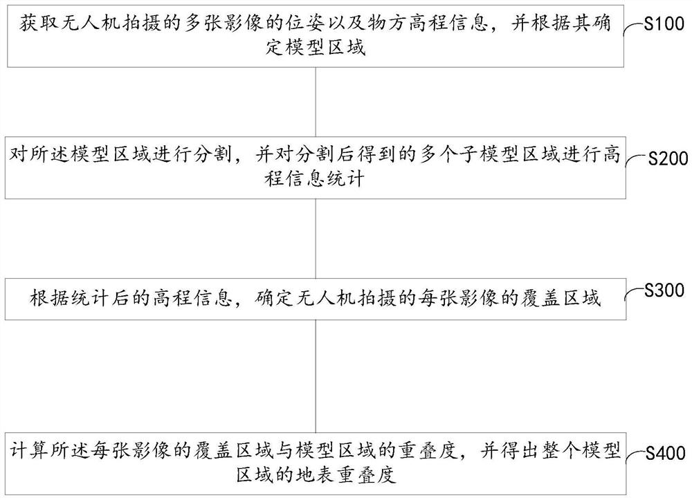
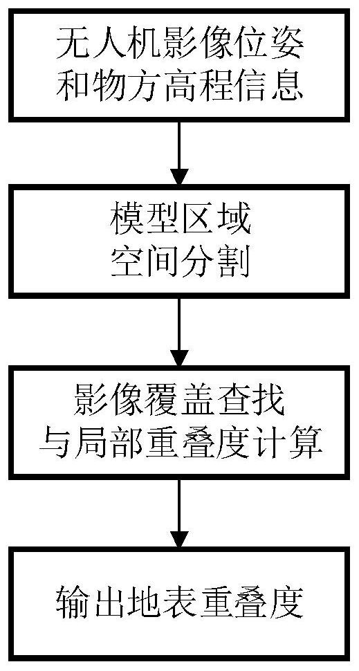
[0044] refer to Image 6 , the second aspect of the present invention provides a UAV photogrammetry overlap calculation system 1 that takes into account surface fluctuations, including: an acquisition module 11 for acquiring the pose and object orientation of multiple images captured by the UAV Elevation information, and determine the model area according to it; the statistics module 12 is used to segment the model area, and perform elevation information statistics on a plurality of sub-model areas obtained after the segmentation; the determination module 13 is used to calculate the elevation according to the statistics. information, to determine the coverage area of ​​each image captured by the drone; the calculation module is used to calculate the overlap between the coverage area of ​​each image and the model area, and obtain the surface overlap of the entire model area.

[0045] Further, the statistics module 12 includes: a determining unit, which determines the constraint...

Embodiment 3

[0047] refer to Figure 7 , a third aspect of the present invention provides an electronic device, comprising: one or more processors; a storage device for storing one or more programs, when the one or more programs are stored by the one or more programs The processors execute such that the one or more processors implement the method of the first aspect of the invention.

[0048] Electronic device 500 may include processing means (eg, central processing unit, graphics processor, etc.) 501 that may be loaded into random access memory (RAM) 503 according to a program stored in read only memory (ROM) 502 or from storage means 508 program to perform various appropriate actions and processes. In the RAM 503, various programs and data necessary for the operation of the electronic device 500 are also stored. The processing device 501 , the ROM 502 , and the RAM 503 are connected to each other through a bus 504 . An input / output (I / O) interface 505 is also connected to bus 504 .

...


PUM


Abstract

The invention relates to an unmanned aerial vehicle photogrammetry overlapping degree calculation method and system considering surface undulation, and the method comprises the steps: obtaining the pose and object space elevation information of a plurality of images shot by an unmanned aerial vehicle, and determining a model region according to the pose and object space elevation information; segmenting the model region, and carrying out elevation information statistics on a plurality of sub-model regions obtained after segmentation; determining a coverage area of each image shot by the unmanned aerial vehicle according to the counted elevation information; and calculating the overlapping degree of the coverage area of each image and the model area, and obtaining the earth surface overlapping degree of the whole model area. According to the method, the image pose and object space elevation information are utilized to quickly and accurately calculate the overlapping degree of the surface undulation area, and the defect that the surface is assumed to be a plane during traditional overlapping degree calculation is overcome, so that the accuracy and adaptability of overlapping degree calculation are improved.

Description

technical field [0001] The invention belongs to the technical field of UAV photogrammetry, and in particular relates to a method and system for calculating the overlap degree of UAV photogrammetry taking into account surface fluctuations. Background technique [0002] UAV photogrammetry has the characteristics of low cost and high efficiency. It is a very effective 3D modeling method and has been widely used in the fields of real 3D construction, disaster emergency and cultural relics protection. [0003] In the real world, the combination of terrain and features is complex and varied. When the drone collects aerial photography data at the same height, when the height of the surface changes greatly, the overlap of the surface is usually small in the area with high altitude, and the overlap of the surface in the area with low altitude is large. If the overlap is too small, the reconstruction quality will be poor; if the overlap is too large, reconstruction will consume a lot...

Claims


Application Information

Patent Timeline
Patent Type & Authority Applications(China)
IPC IPC(8): G06V20/17G06V10/26G06F16/22G06F16/2458G06F16/29G01C11/04
CPCG06V20/17G06V10/267G06F16/22G06F16/2462G06F16/29G01C11/04
Inventor 侯泽鹏
Owner 武汉大势智慧科技有限公司
Why Eureka
Try Eureka