Tailing pond dry beach length automatic monitoring method

A technology for tailings ponds and dry beaches, which is used in measurement devices, surveying and navigation, photogrammetry/video surveying, etc. management level, etc.

Active Publication Date: 2022-08-02
广州翰南工程技术有限公司
View PDF8 Cites 0 Cited by
  • Summary
  • Abstract
  • Description
  • Claims
  • Application Information

AI Technical Summary

Problems solved by technology

However, due to the incomplete detection and monitoring system, backward detection and monitoring technology, and lack of professional testing personnel, many tailings pool management (mainly dry beach length detection) are in a state of no detection and monitoring, and some are in a state of no detection and monitoring, although some have artificial and regular use of traditional instruments. Go to the site for measurement, but affected by many factors such as weather, labor, and site conditions, there are certain system errors and manual errors, which affect the safe production and safety management level of the tailings pond

Method used


Image

  • Tailing pond dry beach length automatic monitoring method

Examples


Embodiment Construction

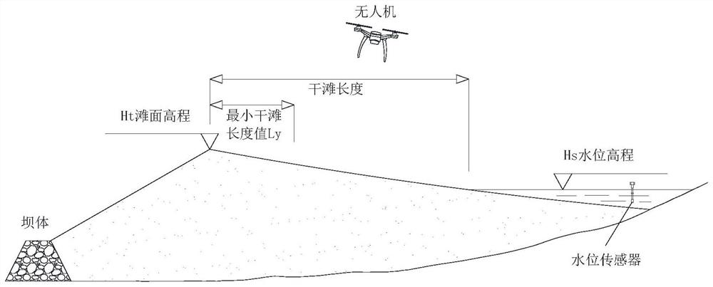
[0023] combine figure 1 , an automatic monitoring method for the length of a tailings pond dry beach, comprising the following steps:

[0024] S1. Establish high-precision orthophotos and three-dimensional models of tailings ponds by means of UAV oblique photography and mapping. The established images and models include digital orthophotographs (DOM) and digital surface models (DSM) for subsequent processing. Process provides material.

[0025] Subdivision step 1: Using the UAV oblique photography method, aerial photography of the tailings pond area, combined with the ground high-precision CORS station post-difference method, establish a high-precision digital orthophoto map (DOM) of the tailings pond with geographic coordinate information and Digital Surface Model (DSM), which can measure and measure the geometric elements of tailings ponds in the computer.

[0026] S2. Based on the digital orthophoto image (DOM) and digital surface model (DSM) of the tailings pond formed i...


PUM


Abstract

The invention discloses a tailing pond dry beach length automatic monitoring method comprising the following steps: S1, through unmanned aerial vehicle photography surveying and mapping, a tailing pond high-precision orthoimage and a three-dimensional model including a digital orthoimage map DOM and a digital earth surface model DSM are established; s2, on the basis of a tailing pond digital earth surface model DSM, the total slope rate of the n section dry beaches is obtained; the average value of the total slope ratios of the dry beaches of the multiple sections is taken as the average slope ratio of the dry beaches of the dam section; extracting water level elevations of n sections and averaging the water level elevations as an initial water level elevation; fitting a function relational expression between the beach face elevation of each section and the length of the dry beach by adopting a function expression; and S3, collecting the water level elevation, uploading the collected water level elevation data to the cloud platform, calculating the current dry beach length by the cloud platform according to the initial dry beach length, the current water level elevation and the function relation between the beach surface elevation and the dry beach length, comparing the calculated dry beach length with a dry beach length early warning threshold value, and judging whether early warning is needed or not.

Description

technical field [0001] The invention relates to the field of engineering safety monitoring and measurement, and the technical field of Internet cloud computing, and more particularly, to an automatic monitoring method for the length of a tailings pond dry beach. Background technique [0002] At present, there are many tailings ponds in my country and they are widely distributed. Many tailings ponds have been in operation for many years, and the storage capacity is gradually decreasing. The ability to resist natural disasters continues to decline, and safety hazards are increasing. The safety of tailings ponds is related to the safety of people's lives, property and the environment in the affected area, so it is of great significance to do a good job in the safety monitoring of tailings ponds. However, many tailings pond management (mainly dry beach length detection) are in a state of no detection and monitoring due to incomplete detection and monitoring systems, backward det...

Claims


Application Information

Patent Timeline
IPC IPC(8): G01C11/00G06T17/00
CPCG01C11/00G06T17/00
Inventor 胡辉林兴立胡荣刘修桥
Owner 广州翰南工程技术有限公司
Why Eureka
Try Eureka