Remote sensing image decision tree classification method and system

A decision tree classification and remote sensing image technology, which is applied in the field of remote sensing and telemetry, can solve problems that have not yet been used in remote sensing image classification systems

Inactive Publication Date: 2006-06-21
RES INST OF FOREST RESOURCE INFORMATION TECHN CHINESE ACADEMY OF FORESTRY
View PDF0 Cites 11 Cited by
  • Summary
  • Abstract
  • Description
  • Claims
  • Application Information

AI Technical Summary

Problems solved by technology

The classification rule generation units of existing remote sensing image classification systems at home and abroad mainly include: parallel pipeline method, Mahalanobis distance...

Method used


Image

  • Remote sensing image decision tree classification method and system
  • Remote sensing image decision tree classification method and system
  • Remote sensing image decision tree classification method and system

Examples


Embodiment Construction

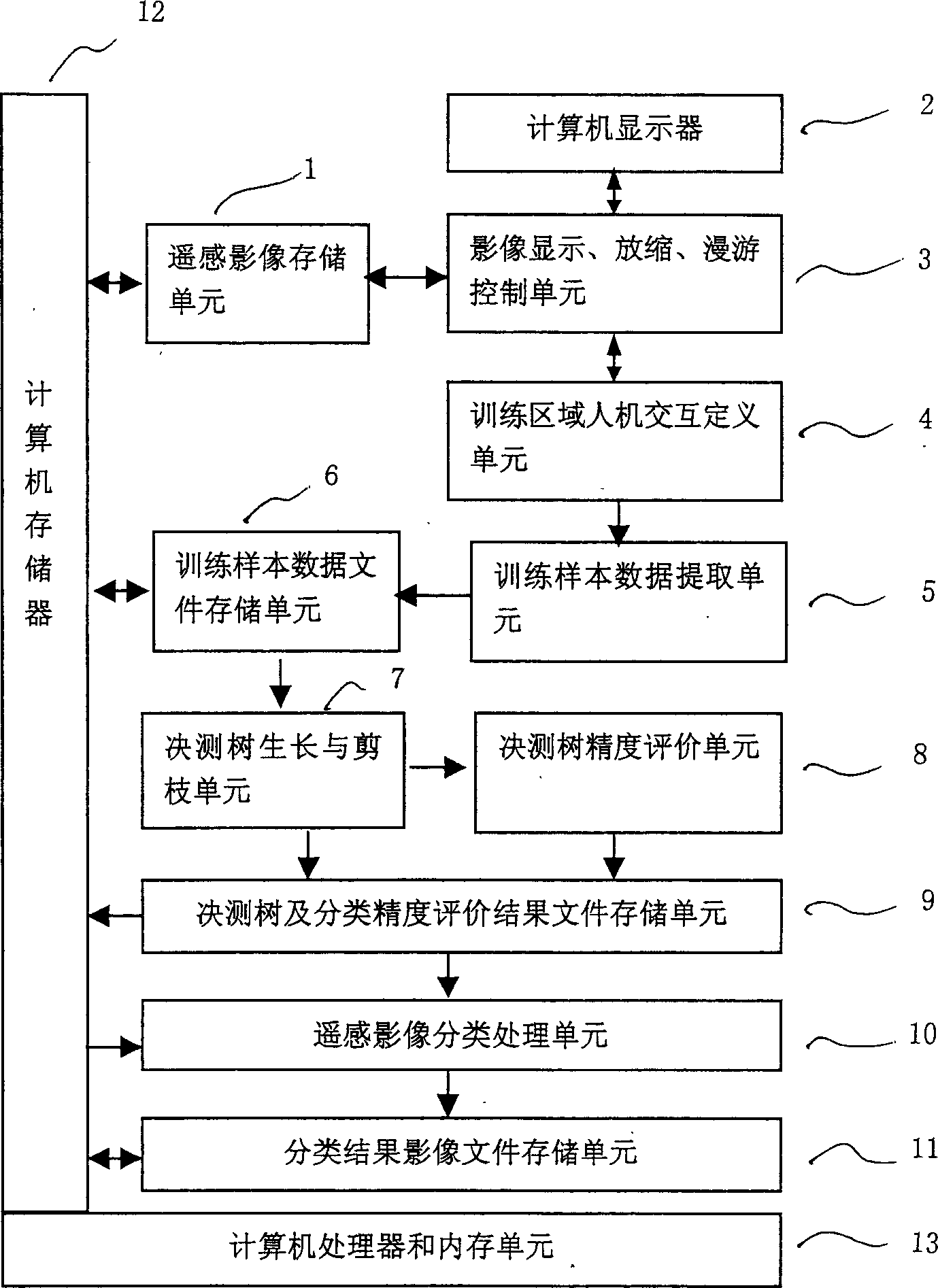
[0047] figure 1 Among them, the structure of remote sensing image decision tree classification system consists of remote sensing image storage unit 1, computer display 2, image display zoom roaming control unit 3, training area human-computer interaction definition unit 4, training sample data extraction unit 5, training sample data file Storage unit 6, decision tree growth and pruning unit 7, decision tree accuracy verification unit 8, decision tree and classification accuracy evaluation result file storage unit 9, remote sensing image classification processing unit 10, classification result image file storage unit 11, wherein , the remote sensing image storage unit 1 is connected between the computer memory 12 and the image display zoom roaming control unit 3, the image display zoom roaming control unit 3 is connected between the computer display 2 and the training area human-computer interaction definition unit 4, the training area The human-computer interaction definition ...


PUM


Abstract

The invention discloses a remote-sensing image decision tree classification system and method, which comprises the following parts: remote-sensing image storage unit, display, image display convergence roaming control unit, exercise domain man-machine interdefining unit, decision tree growth and pruning unit, file storage unit of decision tree growth and classification precision assessment result, remote-sensing image classification disposal unit and classification result image file storage unit. The method comprises the following steps: the starting program starts the program and classification system; the remote-sensing image display program displays the image; the exercise region definition program defines the exercise region; the sample data extraction program extracts the exercise sample data; the decision tree growth and pruning unit forms the decision tree; the precision assessment program calculates the classification precision and assessment index; the remote-sensing image classification disposal program generates the classified result image. The invention can be used in the satellite-borne or airborne sensor, which classifies and disposes kinds of received remote-sensing image.

Description

technical field [0001] The invention relates to the technical field of remote sensing and telemetry, in particular to a remote sensing image decision tree classification system and method. Background technique [0002] Space-borne or airborne sensors can be used to obtain remote sensing images that reflect the spatial distribution and spectral information of the earth's surface features. The coverage of remote sensing images is generally large. It takes a lot of manpower and material resources to identify the spatial distribution of various types of ground objects and generate thematic maps through manual visual interpretation methods, and the classification results are also easily affected by the interpreter's subjective factors. The use of computer equipment and classification systems to carry out computer-aided classification of remote sensing images can not only avoid the non-objectivity of classification results caused by too many subjective factors in manual classifica...

Claims


Application Information

Patent Timeline
IPC IPC(8): G06K9/62
Inventor 陈尔学李增元白黎娜庞勇田昕谭炳香
Owner RES INST OF FOREST RESOURCE INFORMATION TECHN CHINESE ACADEMY OF FORESTRY
Why Eureka
Try Eureka