Vehicular three-dimensional measuring system and method for close-range target

A three-dimensional measurement, vehicle-mounted technology, applied in the field of surveying and mapping, can solve problems such as information acquisition of complex structures of multi-storey buildings, and achieve the effect of strong applicability, suitable accuracy, and efficient geographic coordinate system

Inactive Publication Date: 2006-12-13
SHANDONG UNIV OF SCI & TECH +3
View PDF0 Cites 27 Cited by
  • Summary
  • Abstract
  • Description
  • Claims
  • Application Information

AI Technical Summary

Problems solved by technology

[0003] So far, air-to-ground data acquisition has developed airborne and spaceborne high-resolution, hyperspectral and radar observation technologies, but it has not yet solved the problems of urban high-rise building shelter areas, high-rise building facades, and complex structures of multi-storey buildings. Information acquisition, as well as high-speed, high-precision 3D measurement issues required for cities and many engineering constructions

Method used


Image

  • Vehicular three-dimensional measuring system and method for close-range target
  • Vehicular three-dimensional measuring system and method for close-range target
  • Vehicular three-dimensional measuring system and method for close-range target

Examples


Embodiment Construction

[0036] specific implementation

[0037] The present invention will be further described below according to the accompanying drawings.

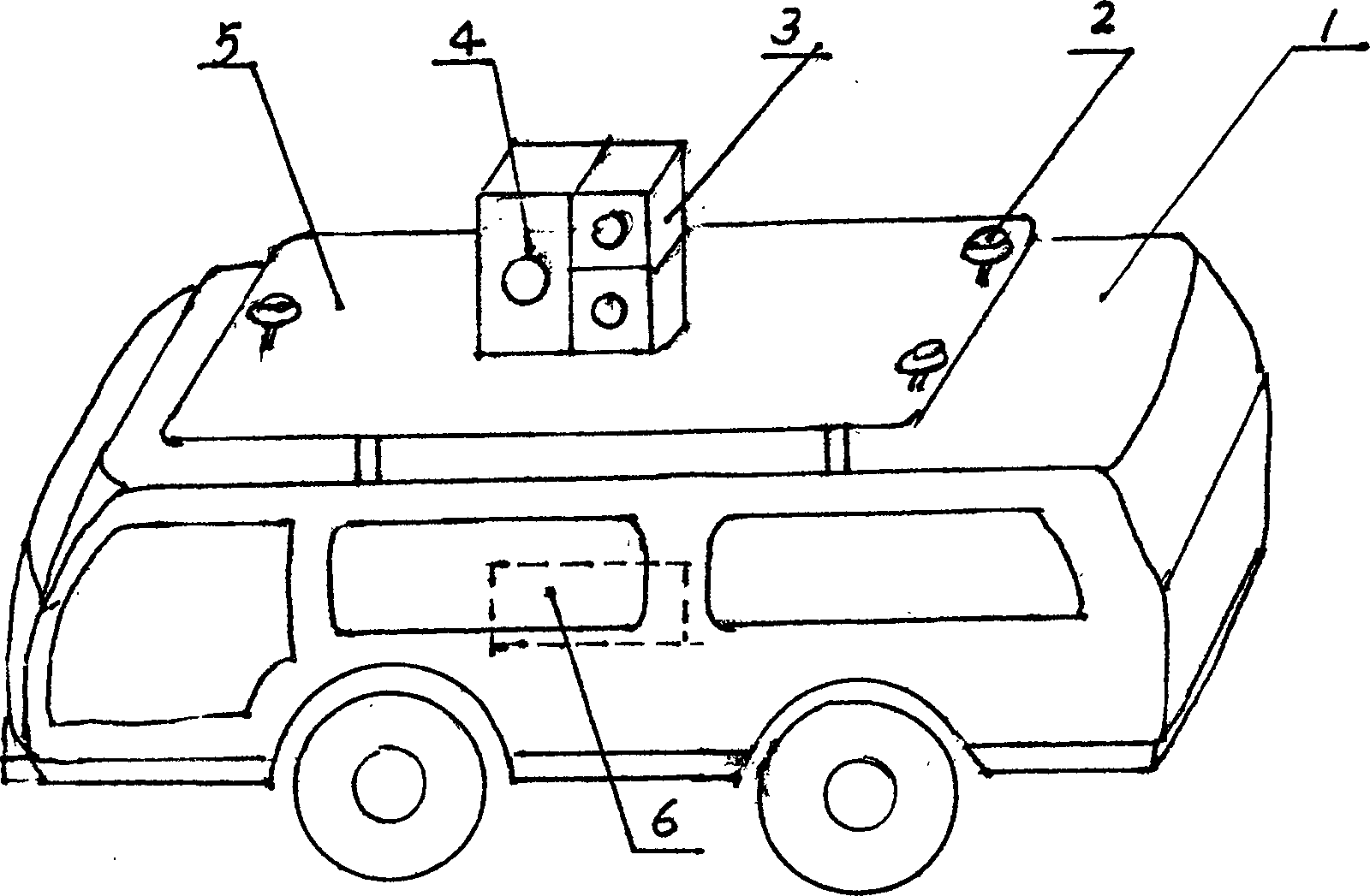
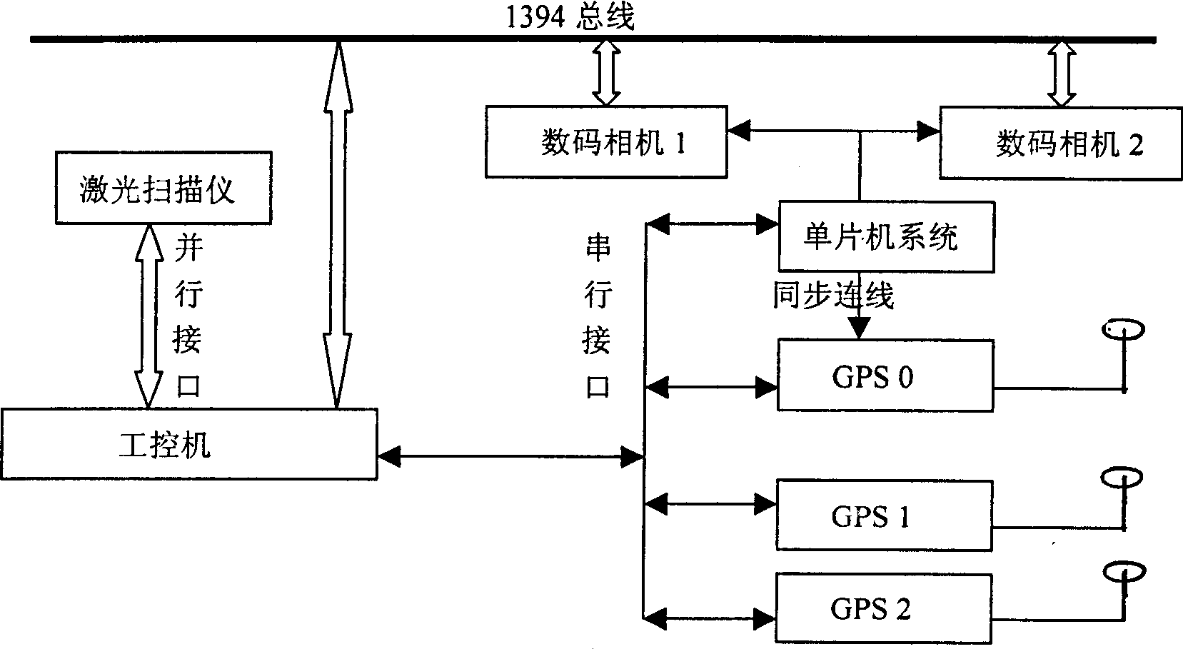
[0038] Depend on figure 1 figure 2 As shown, the system is to install a fixed measurement platform 5 on the top of the mobile vehicle 1, three GPS receiving antennas 2 are installed on three different positions of the platform 5, and a laser scanner 4 and two digital cameras 3 are installed on the platform 5. The cameras 3 are vertically arranged, and usually one works, and when encountering a tall building, the other works at an angle of looking up. An industrial control computer is installed in the vehicle room, and a single-chip microcomputer and GPS-OEM board are installed in the industrial computer chassis 6 . The industrial control computer further expands one IEEE-1394 parallel interface board for image acquisition and control of the digital camera 3; The single-chip microcomputer is connected to the industrial computer through the...


PUM


Abstract

The invention discloses a vehicle-carried close-range target three-dimensional system and a method for making the same. The inventive system comprises a moving measurement vehicle which is characterized in that there is a measurement platform on the top of the moving vehicle, a data collection sensor on the platform which includes a CCD digital camera, a laser scanner and three GPS receiving antennas. Wherein the signal cables of sensor are connected with a collection control system; the three GPS receiving antennas are connected with a GPS receiving board; the signal output cables of the laser scanner are connected to an industrial controller via parallel or serial interface; the signal output cables of the CCD digital camera are connected with the industrial controller via the extended parallel interface; and the control cables of the digital camera are connected with a single chip computer. The inventive method comprises steps of performing outside collection of three-dimensional data of the city close-range object, then reading the collected data from the industrial controller into indoor computer to perform inside process.

Description

technical field [0001] The invention belongs to the field of surveying and mapping, in particular to a three-dimensional measuring system, and mainly serves the "digital city" project. Background technique [0002] The key to the construction of "digital city" lies in the acquisition, management and update of urban spatial information, which is positional, multi-dimensional and time-sequential. Data is the carrier of information. Therefore, the location, multi-dimensionality, and timing of urban spatial information determine that urban spatial data should have certain location accuracy, time accuracy, and complete spatial coordinates and description forms. Therefore, the rapid acquisition of spatial data is the key technology of the "Digital City" project. [0003] So far, airborne and spaceborne high-resolution, hyperspectral and radar observation technologies have been developed for air-to-ground data acquisition, but they have not yet solved the problem of urban high-ris...

Claims


Application Information

Patent Timeline
Patent Type & Authority Applications(China)
IPC IPC(8): G01B21/04G01B11/03G01S1/08
Inventor 卢秀山李清泉李成名陈映鹰冯文灏靳奉祥李贻斌
Owner SHANDONG UNIV OF SCI & TECH
Why Eureka
Try Eureka