Display control method, device, and equipment for depression angle of electronic map

A display control method and a technology of overlooking angles, applied in the field of navigation, can solve the problem that users cannot observe electronic maps, etc., and achieve the effect of satisfying multi-angle observation of navigation images and enhancing navigation effects

Active Publication Date: 2007-07-11
SHENZHEN CARELAND TECH
View PDF0 Cites 142 Cited by
  • Summary
  • Abstract
  • Description
  • Claims
  • Application Information

AI Technical Summary

Problems solved by technology

[0006] The purpose of the embodiment of the present invention is to provide a method for controlling the electronic map overlooking angle display, aiming at solving the problem of dis

Method used


Image

  • Display control method, device, and equipment for depression angle of electronic map
  • Display control method, device, and equipment for depression angle of electronic map

Examples


Embodiment Construction

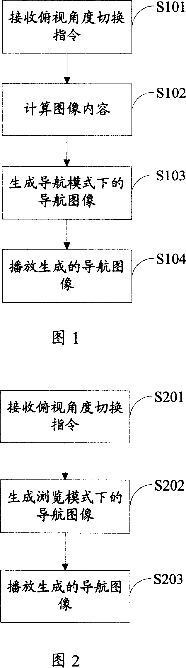
[0026] In order to make the object, technical solution and advantages of the present invention clearer, the present invention will be further described in detail below in conjunction with the accompanying drawings and embodiments. It should be understood that the specific embodiments described here are only used to explain the present invention, not to limit the present invention.

[0027] The embodiment of the present invention uses the perspective projection calculation function set of the electronic map at different overlooking angles, and generates navigation with a three-dimensional effect according to the perspective projection calculation functions at different overlooking angles and the location data and three-dimensional data of the road network and surrounding facilities of the road network. image.

[0028] In the embodiment of the present invention, a perspective projection calculation function set corresponding to each top view angle is configured. Under different...


PUM


Abstract

The invention belongs to the navigation field, and provides an electronic map looking down angle display control method and equipment, and the said method comprises: receiving the switch instruction of the electronic map looking down angle, switching the corresponding prospective projection calculation function, and generating the local three dimensional guide navigation image through the location data and three dimensional data of the surrounding equipment, displaying the said three dimensional guide navigation image. It is used in navigation field, provides an electronic map looking down angle display control method and equipment, and the said method goes like this: receiving the switch instruction of the electronic map looking down angle, switching the corresponding prospective projection calculation function, and generating the local three dimensional guide navigation image through the location data and three dimensional data of the surrounding equipment, displaying the said three dimensional guide navigation image. It increases guide navigation effect, meeting the requirement of multi perspective observation of consumers.

Description

technical field [0001] The invention belongs to the field of navigation, and in particular relates to a display control method, device and equipment of an electronic map overlooking an angle. Background technique [0002] The Global Positioning System (GPS) uses navigation satellites for timing, positioning and ranging, and can provide all-weather, all-round and continuous real-time high-precision three-dimensional space and speed for users at sea, land and air all over the world. and time information. The system is mainly composed of three parts, namely the space part, the ground control part and the user device part. The space part is composed of 24 satellites, which are distributed in 6 track planes. The ground control part is composed of the main control station responsible for managing and coordinating the work of the entire ground control system, the ground antenna that injects the search message into the satellite under the control of the main control station, the m...

Claims


Application Information

Patent Timeline
IPC IPC(8): G01C21/26G01C21/34G01C21/36G01C21/20G01C21/00G01S5/00G01S5/02G01S5/14G08G1/00G08G1/0968G08G1/0969G06F17/30G09B29/00G09B29/10G01S19/38
Inventor 张文星
Owner SHENZHEN CARELAND TECH
Why Eureka
Try Eureka