Locating devices based on antenna coordinates

a technology of antenna coordinates and positioning devices, applied in the field of wireless communication, can solve the problems of ineffective gps, slow device location and location measurement, existing ips solutions, etc., and achieve the effects of stable over time, fast real-time tracking of physical device locations, and quick and efficient determination

Active Publication Date: 2019-10-15
REAVIRE INC
View PDF23 Cites 3 Cited by
  • Summary
  • Abstract
  • Description
  • Claims
  • Application Information

AI Technical Summary

Benefits of technology

[0008]In contrast with existing positioning systems, an improved technique for locating devices both indoors and outdoors detects wireless packets using multiple antenna units and generates antenna coordinates in an antenna coordinate system on a per-packet basis. Information about antenna coordinates are stored in entries of a data store. Packets originating from different locations produce different antenna coordinates, enabling antenna coordinates to differentiate regions in physical space. Although antenna coordinates do not directly describe physical locations, they are stable over time given a stable environment and thus enable quick and efficient determination as to whether a location has been visited before. For example, the technique may generate an antenna coordinate for a location, based on a packet emitted from that location, and may check whether an entry already exists for that antenna coordinate in the data store. The existence of a valid entry confirms that the location has been visited before. In addition, entries in the data store may store Cartesian (physical) coordinates associated with respective antenna coordinates, enabling fast, real-time tracking of physical device locations by simple lookups into the data store based on antenna coordinates.
[0009]Advantageously, the improved technique greatly simplifies the task of tracking packet-emitting devices by matching newly produced antenna coordinates with antenna coordinates previously added to the data store. Such matching greatly relieves processors of the computational burdens normally associated with locating devices. The reduced computational burdens bring particular benefits to systems that track multiple devices in real time, such as gaming systems in which players use packet-emitting wearable devices to track their body and / or limb positions.
[0016]According to some variants, generating the mixed time-of-flight includes correcting a frequency offset error for the packet from time-of-flight measurements. The technique may synchronize all antenna units to a common frequency reference and analyze differences in path lengths across antenna units to identify and remove a frequency offset error.
[0019]In some examples, the improved technique trains Cartesian coordinates to corresponding antenna coordinates based on repeated measurements. For example, entries in the data store represent Cartesian coordinates as centroids, where each centroid provides an average of Cartesian coordinates over multiple measurements. For example, a device that emits a packet may also provide, at the same time the device emits the packet or nearly so, its Cartesian coordinate based on an IMU (inertial measurement unit) or a SLAM (simultaneous localization and mapping) system operating on the device. In some examples, the technique may compute a Cartesian coordinate based on information captured by the antenna units when receiving the packet. These may include geometrical methods based on time-of-arrival, angle-of-arrival, and / or other methods. Each time a Cartesian coordinate is received (or computed) and correlated with an antenna coordinate, the centroid stored in the entry for the antenna coordinate may be updated to reflect the new information, with the precision of the centroid improving upon each update.
[0022]In some examples, the same Cartesian coordinate may map to different antenna coordinates in the data store, even when fingerprints are used, e.g., because of a recent change in the geometry of the physical space. In such cases, the technique maintains a list of antenna coordinates for a particular Cartesian coordinate. Each time one of the antenna coordinates on the list for that Cartesian coordinate is “visited,” i.e., each time a packet is received that produces that antenna coordinate, each of the other antenna coordinates on the list for that Cartesian coordinate is aged out by a predetermined amount, thereby enabling the technique to adapt quickly to environmental changes.

Problems solved by technology

As GPS is often ineffective indoors, a number of Indoor Positioning Systems (IPS) have also been developed.
Unfortunately, existing IPS solutions are generally slow to locate devices and produce location measurements whose accuracy is on the order of meters.

Method used


Image

  • Locating devices based on antenna coordinates
  • Locating devices based on antenna coordinates
  • Locating devices based on antenna coordinates

Examples


Embodiment Construction

[0047]Embodiments of the invention will now be described. One should appreciate that such embodiments are provided by way of example to illustrate certain features and principles of the invention but that the invention hereof is not limited to the particular embodiments described.

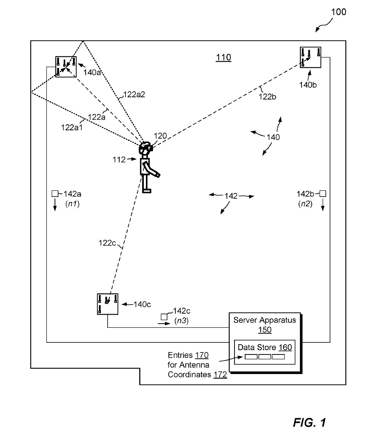
[0048]An improved technique for locating devices detects wireless packets using multiple antenna units and generates antenna coordinates in an antenna coordinate system on a per-packet basis. Entries in a data store associate antenna coordinates with Cartesian (physical) coordinates, enabling fast, real-time tracking of physical device locations by simple lookups into the data store based on antenna coordinates.

[0049]Unlike a Cartesian coordinate system, which is smooth and continuous, the proposed antenna coordinate system may be unsmooth and subject to reflection, refraction, diffraction, and dispersion. Regions that are adjacent in Cartesian space are not necessarily adjacent in antenna space, and vice-v...


PUM


Abstract

A technique for locating devices detects wireless packets using multiple antenna units and generates antenna coordinates in an antenna coordinate system on a per-packet basis. Information about antenna coordinates are stored in entries of a data store. Packets originating from different locations produce different antenna coordinates, enabling antenna coordinates to differentiate regions in physical space. Although antenna coordinates do not directly describe physical locations, they are stable over time given a stable environment and thus allow determination as to whether a location has been visited before. Entries in the data store may store Cartesian (physical) coordinates associated with respective antenna coordinates, enabling real-time tracking of physical device locations by lookups into the data store based on antenna coordinates.

Description

CROSS-REFERENCES TO RELATED APPLICATIONS[0001]Benefit is claimed to U.S. Provisional Application No. 62 / 404,948, filed Oct. 6, 2016, and to U.S. Provisional Application No. 62 / 516,468, filed Jun. 7, 2017. The contents and teachings of these prior applications are incorporated by reference herein in their entirety.BACKGROUND OF THE INVENTION[0002]Field of the Invention[0003]This invention relates generally to wireless communications, and, more particularly, to tracking locations of wireless devices in a physical space.[0004]Description of Related Art[0005]The Global Positioning System (GPS) has become the basis for a wide variety of applications requiring location services. Such services are commonly used in applications for mapping, such as Google Maps and Apple Maps, in applications that provide location-specific content, such as shopping sites and news sites, and in authentication, where device locations may provide authentication factors.[0006]As GPS is often ineffective indoors,...

Claims


Application Information

Patent Timeline
Patent Type & Authority Patents(United States)
IPC IPC(8): G01S5/02G01S5/08
CPCG01S5/0273G01S5/02521G01S5/0263G01S5/0226G01S5/0289G01S5/0294G01S5/08
Inventor GULLICKSEN, JEFF
Owner REAVIRE INC
Why Eureka
Try Eureka