High resolution encoding and transmission of traffic information

a traffic information and high resolution technology, applied in the field of traffic information coding and transmission, can solve the problems of not working api call, “out of memory”, and whole service is non-operational, and achieve the effect of increasing the geospatial resolution of traffic information

Active Publication Date: 2020-09-22
SIRIUS XM RADIO INC
View PDF10 Cites 3 Cited by
  • Summary
  • Abstract
  • Description
  • Claims
  • Application Information

AI Technical Summary

Benefits of technology

[0058]Systems and methods are provided for increasing the geospatial resolution of traffic information by dividing known location intervals into a fixed number of sub-segments not tied to any one map providers format, efficient coding of the traffic information, and distribution of the traffic information to end-user consuming devices over one or more of a satellite based broadcast transport medium and a data communications network. Exemplary embodiments of the present invention detail a nationwide traffic service which can be encoded and distributed through a single broadcast service, such as, for example, an SDARS service, or a broadcast over a data network. Exemplary embodiments include aggregating the traffic data from segments of multiple location intervals, into predefined and predetermined flow vectors, and sending the flow vectors within a data stream to users.
[0063]3. Define a method whereby highway linear segments that traverse two or more broadcast service areas can be broken at the service boundaries, and reassembled again at the application level with no possibility of gaps in coverage.
[0068]8. Implement a data delivery mechanism where large volumes of data that do not need to be processed by a specific application can be efficiently detected, filtered out and discarded by the processing software reducing the volume of information that must be managed for a localized regional area.
[0069]9. Further efficiently divide the data delivery mechanism into multiple temporal domains (e.g. current, predictive, forecast and historical periods) each of which may be independently filtered.

Problems solved by technology

A Weak error indicates that the API call is not going to work, but other calls may, for example starting a service when the service is already running.
A Strong error indicates that the whole of the service is non-operational.
A possible Strong error could be: “Out of Memory” when starting the service.
Other services may continue to operate, but the requested service is unable to initialize, and will not operate correctly (or at all).
The routine will block if there is an extraction currently in progress, and will fail if it is called from within a notification callback routine.
This is not a complete application ready to drop into an automotive system and provide a full Apogee traffic service.

Method used


Image

  • High resolution encoding and transmission of traffic information
  • High resolution encoding and transmission of traffic information
  • High resolution encoding and transmission of traffic information

Examples


examples

[2416]Run the default demonstration around Philadelphia:[2417]apogee demo

[2418]Process data in the Los Angeles MBR for 60 minutes processing change every 31 seconds with the debug level 0x0ff2f007:[2419]apogee demo r_la i31 l60 d0x0ff2f007

[2420]Control

[2421]The following commands control the module as a whole:[2422]apogee start [debug] starts the apogee module with debug level [debug] (or 0)[2423]apogee debug [debug] resets the apogee debug level to [debug] (or 0)[2424]apogee status returns and displays the apogee status object[2425]apogee stop terminate the apogee service

[2426]Requests

[2427]Collection Requests are built up using a sequence of CLI operations[2428]req=apogee vrequest allocates an empty request object and stores it in the req variable[2429]apogee add_bsas $req; $mbr; adds all the BSAs that intersect mbr into the allocated req apogee req_request $req; types $handle;[2430]submits the collection request req to the apogee module and[2431]saves the returned request handle ...

example

[2478]The following example script is similar to the Philadelphia demonstration, but showing how the individual commands can be joined into a set of test cases. The user should refer to the “Running the CLI” section of “SX-9845-0340 Introduction Design Guide” for setting up the necessary files and how to run the SDK data services CLI application.

[2479]

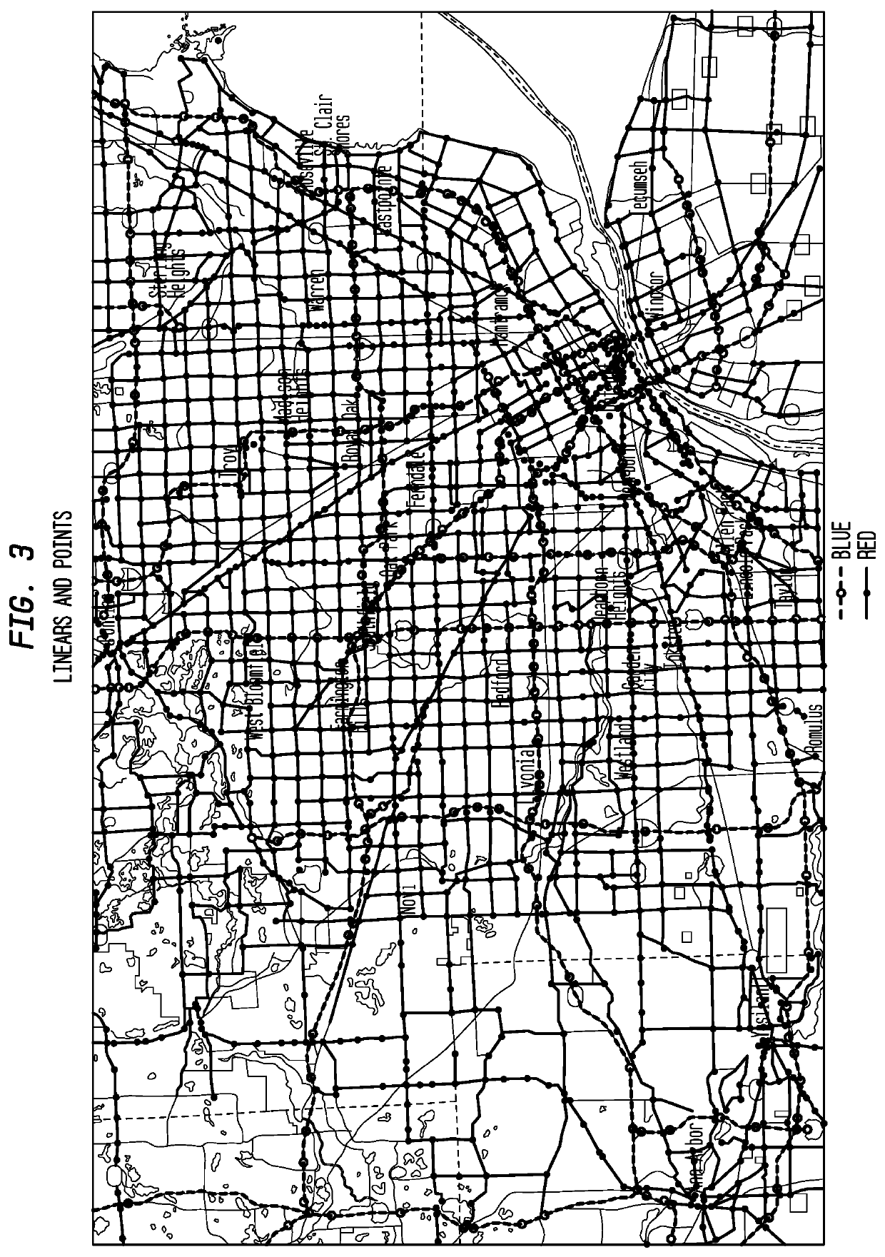
 say “START”audio startapogee start 0x00000000#Let the service come up.say “Wait 5 sec for service to start...”sleep 5say “Wait end.”## Philly area requests#say “Request Philly area.”req = apogee vrequestmbr1 = mbr −75.212 39.693 −75.093 39.995apogee add_bsas $req; $mbr1;apogee show $req;filter = apogee vfilterapogee add_all_linears $filter; $mbr1; $req;apogee show $filter;apogee add_all_ramps $filter; $mbr1; $req; 0apogee show $filter;apogee add_all_ramps $filter; $mbr1; $req; 1#used for subsequent extractions in phillyextract scriptsvlanecount = integervlinearcount = integervflowvec = apogee vflowvecvchanged = integervlanetype = apog...


PUM


Abstract

Systems and methods are provided for increasing the geospatial resolution of traffic information by dividing known location intervals into a fixed number of sub-segments not tied to any one map providers format, efficient coding of the traffic information, and distribution of the traffic information to end-user consuming devices over one or more of a satellite based broadcast transport medium and a data communications network. Exemplary embodiments of the present invention detail a nationwide traffic service which can be encoded and distributed through a single broadcast service, such as, for example, an SDARS service, or a broadcast over a data network. Exemplary embodiments include aggregating the traffic data from segments of multiple location intervals, into predefined and predetermined flow vectors, and sending the flow vectors within a data stream to users. Confidence levels obtained from raw traffic data can both (I) be disclosed to drivers / users to supplement a very low signal (or no signal) speed and congestion report, and (ii) can also be used in various system algorithms that decide what local anomalies or aberrations to filter out as noise, or to disclose as accurate information and thus more granularly depict the roadway in question (and use additional bits to do so) as an actual highly localized traffic condition.

Description

CROSS-REFERENCE TO RELATED APPLICATIONS[0001]This application is a continuation-in-part of co-pending International Application No. PCT / US2014 / 029221, designating the United States, with an international filing date of Mar. 14, 2014, and also claims the benefit of U.S. Provisional Application No. 61 / 785,663 filed on Mar. 14, 2013, to which benefit and priority were claimed in PCT / US2014 / 029221, the disclosures of each which are incorporated herein by reference in their entireties.TECHNICAL FIELD[0002]The present invention relates to traffic information coding and transmission, and in particular to a method of increasing the geospatial resolution of traffic information by dividing known location intervals into a fixed number of sub-segments, efficient coding of the traffic information, and the distribution of the traffic information to end-user consuming devices over a satellite based broadcast transport medium.BACKGROUND OF THE INVENTION[0003]Various proposals have been presented fo...

Claims


Application Information

Patent Timeline
Patent Type & Authority Patents(United States)
IPC IPC(8): G08G1/01G08G1/09H04H20/55
CPCG08G1/0129G08G1/092G08G1/012H04H20/55G08G1/0141G08G1/091
Inventor FRENCH, LESLIE JOHNDOMBROWSKI, JOHN EDWARD
Owner SIRIUS XM RADIO INC
Why Eureka
Try Eureka