Second order complementary global positioning system/inertial navigation system blending filter

a global positioning system and filter technology, applied in the field of navigation systems, can solve the problems of low data rate of position solution, high cost and complexity of prior art solution, and short-term nois

Inactive Publication Date: 2002-02-14
HONEYWELL INT INC
View PDF0 Cites 23 Cited by
  • Summary
  • Abstract
  • Description
  • Claims
  • Application Information

AI Technical Summary

Problems solved by technology

However, while such signals provide excellent long-term position accuracy, they are noisy in the short-term.
A further disadvantage of GPS is that the data rate of the position solution is lower than desirable for smooth, stable aircraft guidance.
The INS signals exhibit excellent short-term accuracy and smoothness, but they suffer from long-term drift that produces position errors that are unbounded with time.
This prior art solution...

Method used


Image

  • Second order complementary global positioning system/inertial navigation system blending filter
  • Second order complementary global positioning system/inertial navigation system blending filter
  • Second order complementary global positioning system/inertial navigation system blending filter

Examples


Embodiment Construction

)

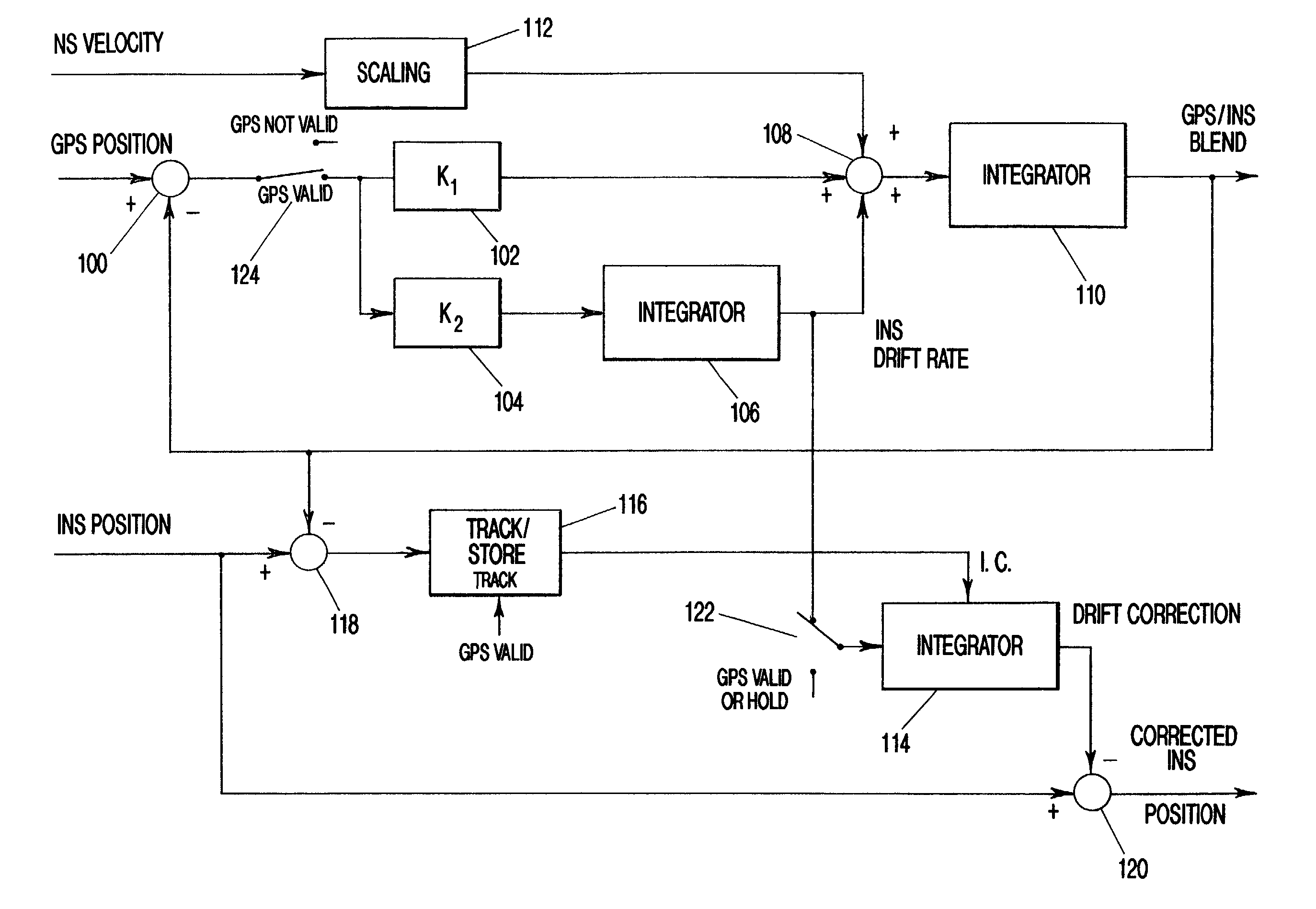
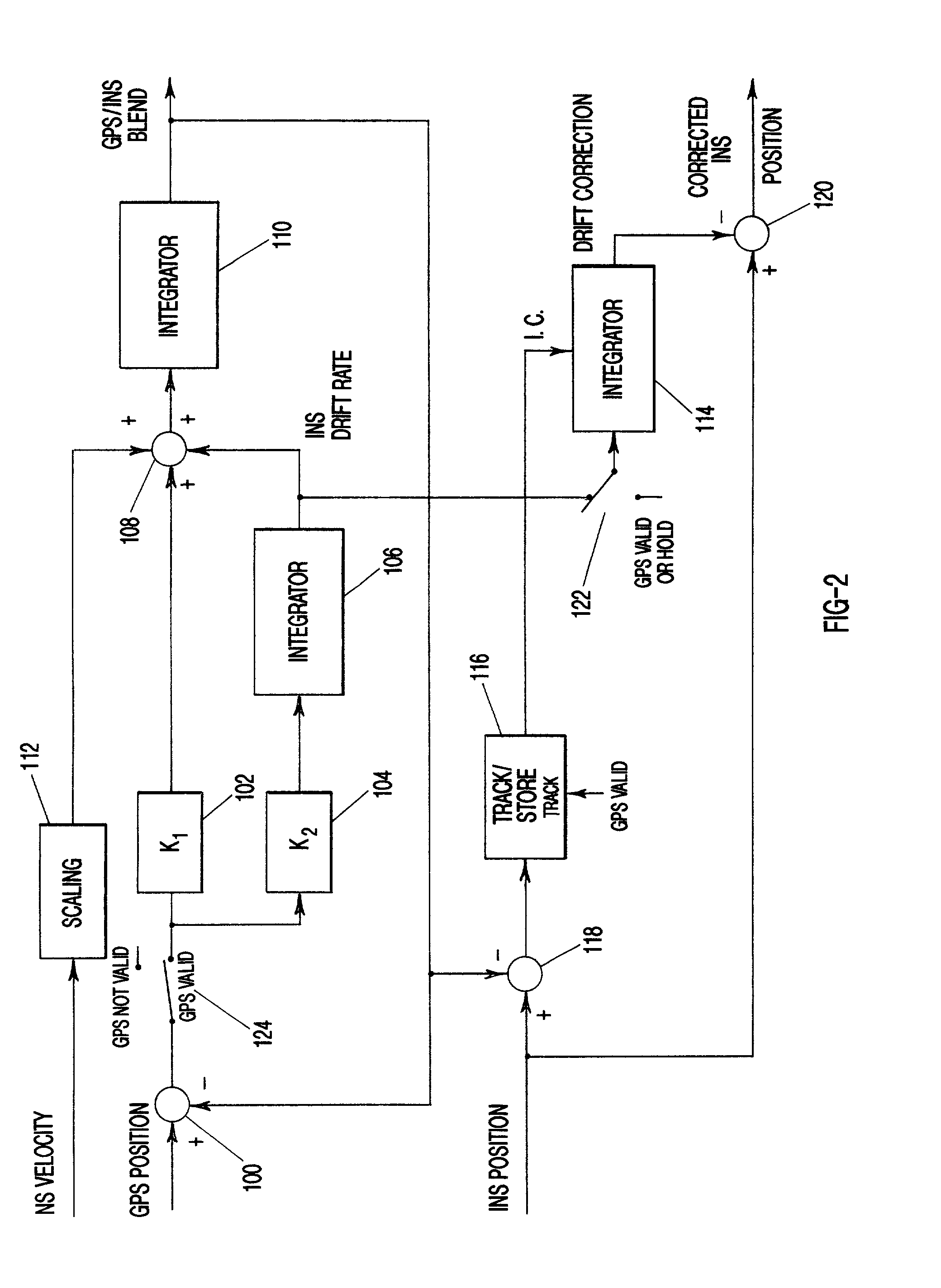
[0027] Disclosed is an apparatus and method that uses a second order complementary filter to determine drift rate of an INS, and the use of this drift rate to improve the correction to the position error of the INS. Also disclosed is the use of a second order complementary filter to correct an INS velocity signal so that this corrected velocity signal can be used to compute accurate position information in the presence of momentary interruption of GPS.

[0028] As shown in FIG. 2, the preferred embodiment comprises a second order complementary filter made up from integrators 106 and 110, gain blocks 102 and 104, summing junctions 100 and 108, and scaling block 112; an INS correction "loop" consisting of summing junctions 118 and 120, a Track / Store function 116, and an integrator 114; and switches 122 and 124.

[0029] Note that the embodiment shown in FIG. 2 represents one of several essential filters used to smooth position and velocity information and to correct for position and veloci...


PUM


Abstract

A second-order filter that blends accurate position information from a one source, and velocity information from another source, both suitably scaled, in a second-order complementary filter. The filter is arranged such that an internal integrator maintains a value that represents the difference in the rate of change of the accurate position information, and the velocity input of the other source. This velocity difference is applied to another integrator outside the filter, whose initial condition is the position error between the two sources to the second order filter. The output of this latter integrator is a correction signal that grows at a rate equal and opposite to the rate of error build-up of position data from the source whose velocity is used in the second order filter. This correction signal is summed with the original position signal. In addition, the output of the second order filter may be used as a highly accurate position signal.

Description

[0001] This application claims priority to Provisional Application, Serial No. 60, 221,314, filed Jul. 28, 2000.[0002] 1. Field of the Invention (Technical Field)[0003] This invention relates to navigation systems, and, in particular, airborne navigation and guidance systems utilizing the computation of position and velocity for automatic guidance.[0004] 2. Background Art[0005] Modern navigation systems utilize extremely accurate signals from a constellation of satellites that comprise the Global Positioning System (GPS) to compute position. However, while such signals provide excellent long-term position accuracy, they are noisy in the short-term. This is particularly true of the velocity data provided. Velocity data as well as position data is required to provide smooth, stable guidance. A further disadvantage of GPS is that the data rate of the position solution is lower than desirable for smooth, stable aircraft guidance.[0006] Current practice is to augment the GPS signals with...

Claims


Application Information

Patent Timeline
IPC IPC(8): G01C21/00B64D45/00G01S5/14G01S19/19G01S19/40G01S19/47G01S19/49G08G5/00
CPCG01C21/165G01S19/40G01S19/47G01S19/49G08G5/00
Inventor MILLER, RONALD J.
Owner HONEYWELL INT INC
Why Eureka
Try Eureka