
Method of organizing information into topical, temporal, and location associations for organizing, selecting, and distributing information

a technology of topical, temporal and location associations, applied in the field of method of organizing event-based information, can solve the problems of cumbersome and restrictive, difficult to see by viewers, and the available methods have not yet enabled viewers to smoothly call forth sets of graphic and textual data

Inactive Publication Date: 2003-10-23
GLOBAL SCI & TECH
View PDF14 Cites 292 Cited by
  • Summary
  • Abstract
  • Description
  • Claims
  • Application Information

AI Technical Summary

Benefits of technology

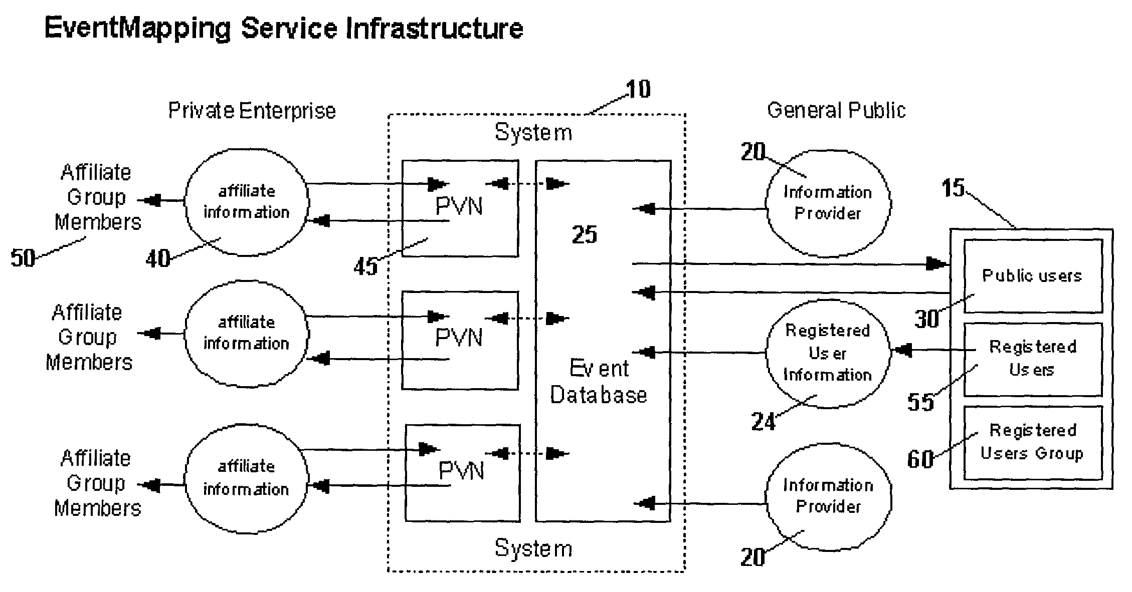
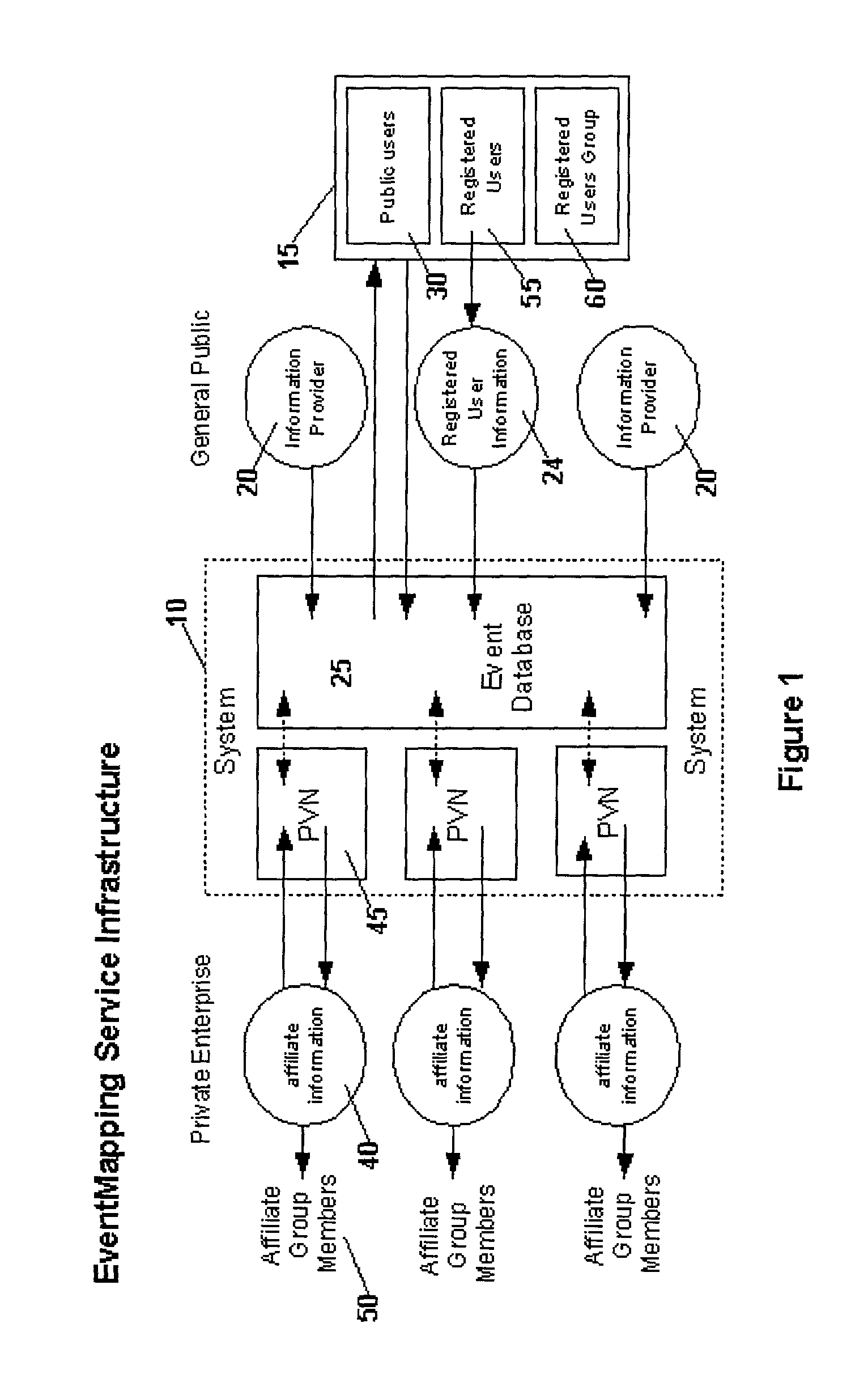
[0033] An advantage of the present invention is that it can provide a means for public distribution of event information by topical, temporal, and / or location associations for any event type or geographic scale over the Internet and various other distribution devices including, for example, any PC connected to the Internet, an intranet, a personal virtual network (PVN), or any email system, any other device connected to these systems such as a personal digital assistant (PDA), visual display device, wireless or wire-based telephonic device, e.g. telephone, cell phone, fax, and the like.
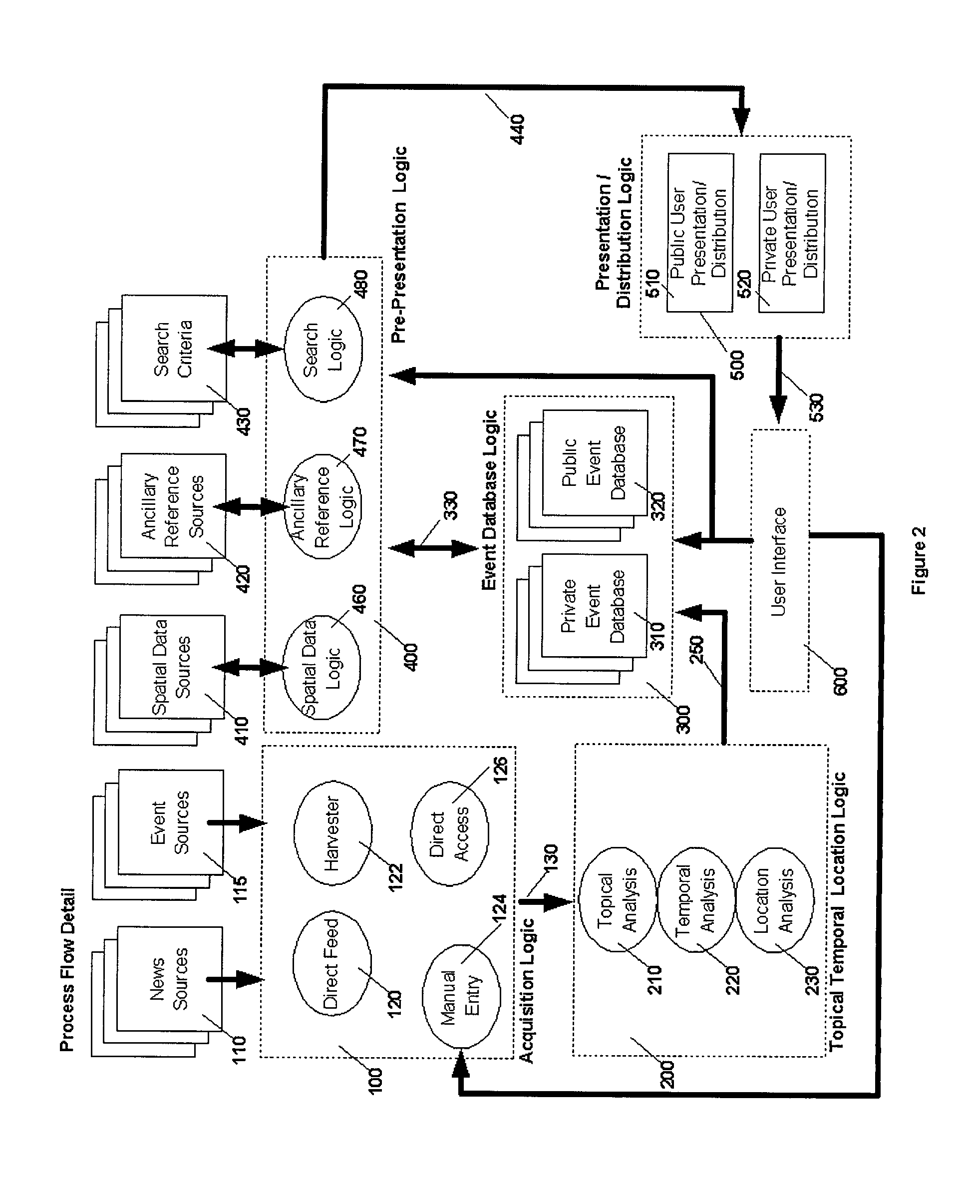
[0034] Another advantage of the present invention is that it provides a means whereby event based information subsets can be derived based on associations cross referenced by topic, time, and location, either single values, ranges, or categories of any or all of those attributes. In an embodiment of the invention, attribute selection criteria and event display may be accomplished through an interactive web-based user interface with a selection / display window for each attribute and an enhanced display based on one attribute according to user specification. The attribute windows allow users to select values or ranges of any or all of topics, times and location specifically or by interaction with the display in an attribute window. For example times may be selected either by marking dates on a calendar or by typing a date reference in the temporal attribute window; topics may be selected by typing words or phrases or by selecting from lists of topics arranged hierarchically in the topic attribute window; location selection may be set by typing a street address, intersection, geographic proper noun or by zooming or panning on a map displayed in the location attribute window. Displayed events will be reflective of the combination of search criteria set by the user. The geographic display will be correlated with displayed events by display type and scale from information in the geographic reference source; it may be a relief map, a street map, an aerial photograph, a floor plan diagram, or any other location display available from public sources or provided for specific applications.
[0035] Displayed event information text may have geographic hyperlink extensions associated with any geographic proper noun. Selecting such hyperlinks may reset the location attribute window display, and provide an additional means of setting location attribute selection criteria.
[0036] Among advantages of the present invention may be that it provides a unified means with which to promote future events, identify current events, and provide access to historic events. It provides information for data mining research means to establish cross referencing of event based information by topic, time, and / or location to identify patterns, trends, and other behaviors.
[0037] It provides means to continually ingest event based information, provide event information updates to a diverse audience of information consumers, and to support decision making. The method allows acquisition of event information by means of direct feed, harvesting publicly available sources of event information, direct access to event information or manual entry of event information to the system by web or other form, voice recognition conversions, from audio, video, multimedia formats, or any other source of event information that is perceptible. In an embodiment of the invention event information may be ingested from sources in formats ranging from Extensible Markup Language (XML), Hypertext Markup Language (HTML), News Industry Text Format (NITF), Wireless Markup Language (WML), and Rich Text Format (RTF) to standard multimedia formats, data exchange formats, delimited, plain text, and the like.
[0038] In one embodiment of the present invention, the user interface may also comprise a submission interface enabled for registered users to submit, manage, and distribute event information.

Problems solved by technology

Paper drawings and maps, e.g., spatial data, are representations of the real world; but often the viewer must struggle to see only what is relevant amidst too much information.
Transparent overlays can separate graphic information, but are cumbersome and restrictive.
However, available methods have not as yet enabled viewers to smoothly call forth sets of graphic and textual data to inform and stimulate a sustained, multifaceted, analytical thought process.
However, non-technicians, e.g., the public, executives, and experts in non-computer fields, cannot easily use these programs to access and manipulate selections of coextensive data sets.
Nor can they easily create or assemble their own sets of interactive, coextensive data sets.
The spatial data used in GIS are often static in nature and only updated on a periodic basis, making access to "real-time" data rare.
Spatial data are often of different scales, projections, and origin making them difficult to integrate without intensive processing efforts.
The current state of GIS technology does not adequately provide for seamless access to numerous subset combinations from coextensive data sets.
Through current technology the material is not viewed smoothly, in direct association with the map feature, thereby minimizing the value and use of the map.
Current reference CD-ROMS are organized to incrementally access graphic and text information on a single subject, but are not presently designed to enable comparison and to enhance prolonged, dynamic visual analysis.
While searchable GIS maps and e-commerce shopping sites are growing to be among the more popular image-intensive applications on the Web, the quality of their interactivity and usefulness for visual analysis and comparison is extremely low.

Method used


Image

  • Method of organizing information into topical, temporal, and location associations for organizing, selecting, and distributing information
  • Method of organizing information into topical, temporal, and location associations for organizing, selecting, and distributing information
  • Method of organizing information into topical, temporal, and location associations for organizing, selecting, and distributing information

Examples


Embodiment Construction

[0051] Reference will now be made in detail to the principles of the present invention, examples of which are illustrated in the accompanying drawings.

[0052] In an embodiment of the present invention, an event information processing system of processing event based information for distribution and display in an event information processing system includes a database and associated software for acquiring, indexing, storing, and retrieving event based information. The event based information may be characterized by topic, time, and location attributes. Display means may be provided which are capable of displaying the event based information. The event based information may be displayed as event information reflective of a query dictated by search criteria comprising coextensive ranges of topic, time, and location.

[0053] The method includes acquiring and organizing information into topical, temporal, and location associations, including applying semantic rules for parsing textual event...


PUM


Abstract

An event information processing method of processing event based information in an event information processing system for organizing and accessing event information includes steps of acquiring event based information from at least one information source, wherein event based information comprises attributes associated with topic, time, and location, and identifying topical, temporal, and location attributes from the event information that are used to organize the event information for selection and correlation with other event information. Topical, temporal, and location attributes are extendable by means of a topical hierarchical category resource, location and temporal hierarchical category resources or by application specific attribute information. The event information is storable in an event repository along with its topical, temporal, and location attributes. Event information is distributable to users authorized to access subsets of information, according to user specified or predetermined combined selection criteria of values, ranges or categories of topical, temporal, and location attributes.

Description

[0001] 1. Field of the Invention[0002] The present invention relates to a method of organizing event based information by topical, temporal, and location attributes; along with selection and distribution of the event information by criteria based on values of those attributes.[0003] 2. Discussion of the Related Art[0004] Throughout the ages, humans have devised ways to record, then examine, their thoughts and mental images on paper. People draw depictions of events, places, projects, and sets of objects. They chart scientific processes, demographics, weather conditions, and mechanical systems; and they diagram organizations, trade routes, music, and inventions. These drawings aid both the originator and subsequent audiences in picturing spatial or symbolic relationships. Paper drawings and maps, e.g., spatial data, are representations of the real world; but often the viewer must struggle to see only what is relevant amidst too much information. Transparent overlays can separate grap...

Claims


Application Information

Patent Timeline
IPC IPC(8): G06F17/30
CPCG06F17/3087G06F16/9537
Inventor BELL, BRIAN L.VENIGALLA, SRINIVASPAGE, RICHARD W. JR.GOURCE, NATHALIE
Owner GLOBAL SCI & TECH
Learn More