Systems and methods for fault detection and exclusion in navigational systems

a navigation system and fault detection technology, applied in the field of navigational systems, can solve the problems of inability to provide horizontal position integrity information, system that provides ranging signals for navigation purposes also has similar problems, and the gps satellites are subject to significant errors, so as to reduce the likelihood of erroneous identification, reduce computational intensity, and improve the likelihood of rapid and successful identification

Inactive Publication Date: 2005-05-05
GARMIN AT
View PDF19 Cites 14 Cited by
  • Summary
  • Abstract
  • Description
  • Claims
  • Application Information

AI Technical Summary

Benefits of technology

[0016] The system and method of the present invention have several advantages. First, because the first threshold value, (fault detection threshold), is set relatively low, the system detects the presence of faulty ranging signals at an early stage. This allows the system to provide an early warning to other systems that one or more satellites or other ranging sources may not be functioning properly. Second, configuring the system to wait until the HUL value has reached a second threshold (preferably corresponding to a relatively high percentage of HAL) before attempting to determine which ranging signal(s), (e.g., GPS signals), is in error increases the likelihood of quickly and successfully identifying the faulty ranging signal and minimizes the likelihood of erroneously excluding a valid ranging measurement.
[0017] Furthermore, the second threshold, (i.e., fault isolation threshold), of the present invention preferably varies with variable alarm limits, (i.e., a factor of HAL). The calculation of a variable position error (second) threshold that triggers the detection and isolation function is much easier and less computationally intensive than calculating a variable residual error (first) threshold. In particular, a variable position error threshold is computed by multiplying the HAL by a percentage, while a variable residual error threshold must be determined by running thousands, and in some cases millions, of offline simulations. These simulations typically cannot be run on the target system because they are computationally intensive and time consuming and cannot be run in real-time systems such as GPS receivers. In addition, because the thresholds must be determined for each degree of freedom of the system, which is the number of ranging signals in the system minus four, computing multiple variable position error thresholds is significantly less time consuming than computing multiple variable residual error thresholds.
[0018] Furthermore, the fault detection in the FDE systems and methods of the present invention are independent of the operational mode because fault detection is based upon ranging measurements, missed alert requirements, and false alert requirements, not operational requirements. Thus, a complete set of second thresholds for each HAL (one for each operational mode) is not needed in the present invention and provides increased flexibility for changes in the system. Examples of aircraft operational flight modes are: oceanic, en route, terminal, non-precision approach, and precision approach.

Problems solved by technology

The broadcast ranging signals generated by the GPS satellites are subject to significant errors due to anomalies in the satellite clocks, broadcast data, and atmospheric contributions, such as ionospheric and tropospheric effects.
Other types of systems that provide ranging signals for navigation purposes also have similar issues.
These errors, as well as other errors in signals transmitted from GPS satellites and other ranging devices, can cause significant problems in navigation systems, such as aircraft navigation systems, which use GPS receivers and GPS satellite signals to calculate a navigation solution.
Due to potential inaccuracies in the navigational data caused by various GPS anomalies and / or other ranging sources, aircraft are typically provided with a backup navigational system that is used when the navigational data provided by the primary system, (e.g., GPS system), is not sufficiently accurate for navigational purposes.
Where such a minimum plurality of ranging signals is not available, the RAIM internal consistency check is not available; therefore, horizontal position integrity information is not available.
In addition, RAIM may also generate error values based upon the consistency check, which are then compared to predetermined error limits.
This alarm is a warning to the user that although horizontal position data may be available, it may be erroneous.
In such instances, where RAIM is not available or a RAIM alarm is generated, the integrity of the navigation solution is questionable.
If the RAIM function detects a faulty measurement, the RAIM function is unable to determine which of the measurement(s) (one or more) is faulty.
Prior art systems are known to delay the FD function until the position error has grown to be close to, yet below, the allowable position error for the given operation.
Attempts to isolate the faulty signal too early can result in an incorrect identification, because the errors have not become significantly large enough to accurately detect which signals are in error.
Thus, although there is a need to detect a fault as soon as possible in the interest of operational safety, attempting isolation of the faulty signals prematurely leads to incorrect determinations of faulty signals.

Method used


Image

  • Systems and methods for fault detection and exclusion in navigational systems
  • Systems and methods for fault detection and exclusion in navigational systems
  • Systems and methods for fault detection and exclusion in navigational systems

Examples


Embodiment Construction

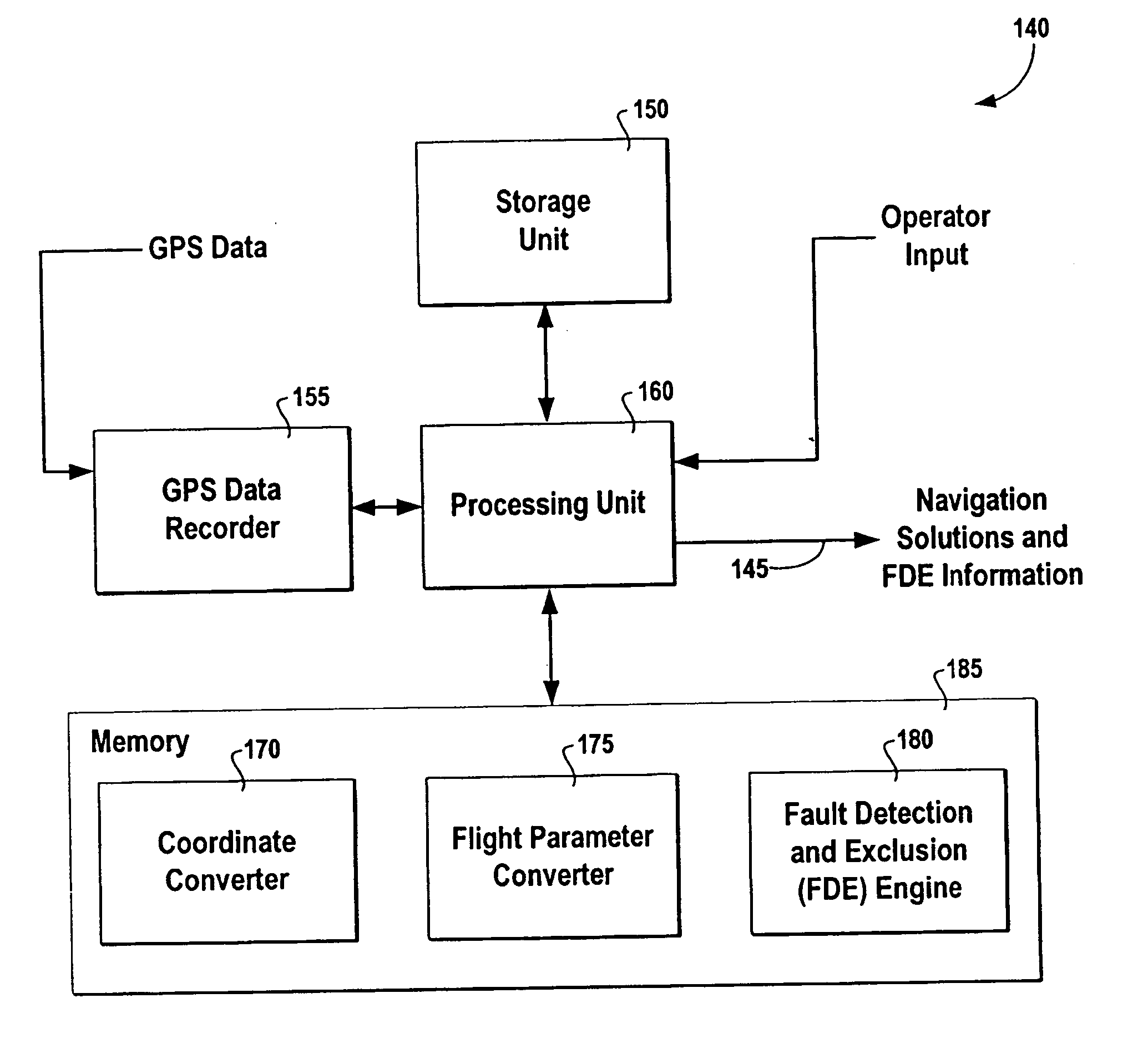
[0026] The present invention now will be described more fully hereinafter with reference to the accompanying drawings, in which some, but not all embodiments of the invention are shown. Indeed, these inventions may be embodied in many different forms and should not be construed as limited to the embodiments set forth herein; rather, these embodiments are provided so that this disclosure will satisfy applicable legal requirements. Like numbers refer to like elements throughout.

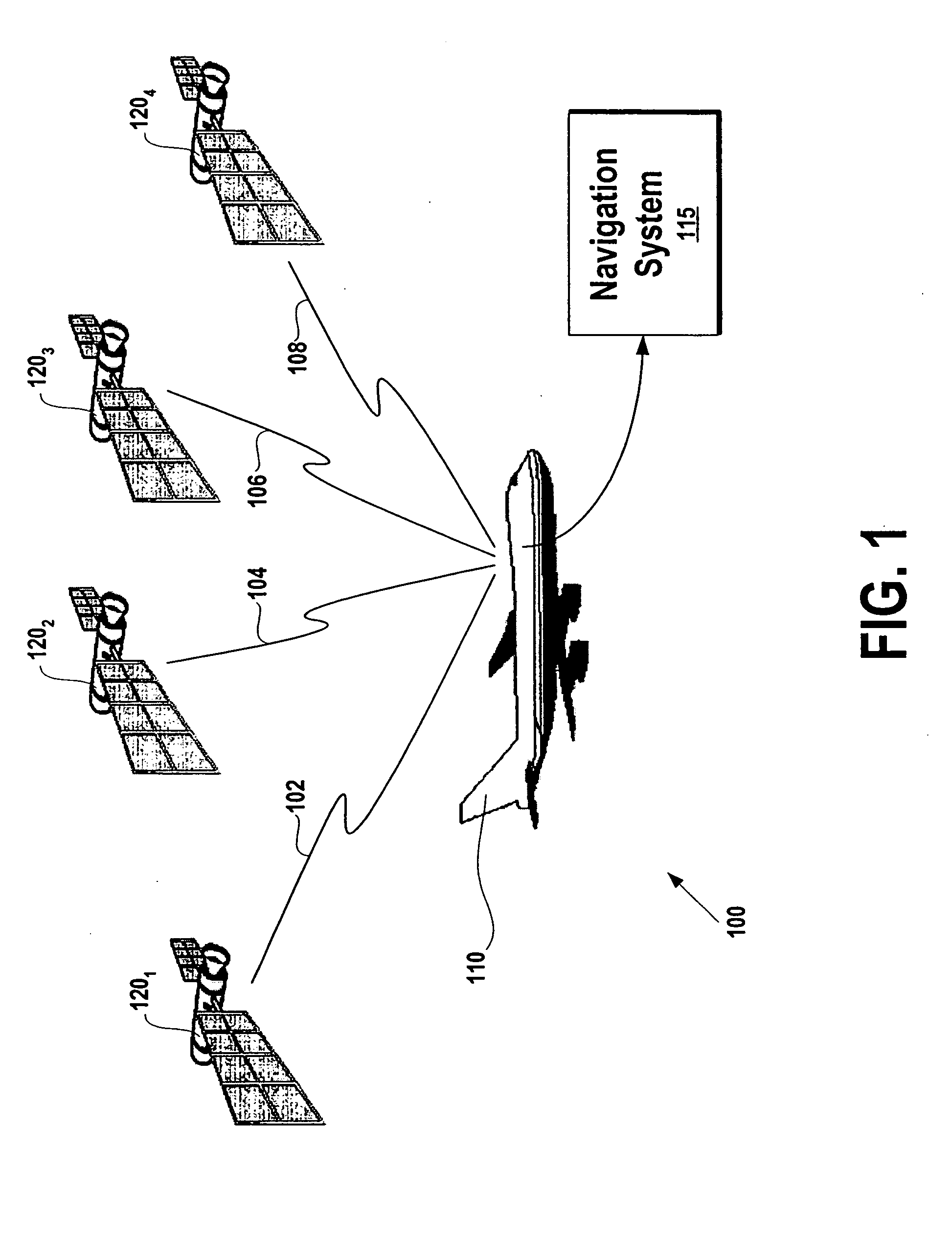
[0027] The present invention is described below in conjunction with a Global Positioning System (GPS). It is understood, however, that the present invention can be applied to any ranging technology, where the invention is supplied with ranging data from multiple sources for determining navigational information. The invention is described below in a GPS system merely to aid in the understanding of the invention to other types of ranging sources and systems. For example, the system could be used with laser and r...


PUM


Abstract

The Fault Detection and Exclusion (FDE) system for use in navigational systems that rely upon multiple ranging signals, such as GPS satellites, uses an FDE algorithm to detect, as soon as possible, whether a fault exists in a signal associated with one or more of the GPS satellites. The system makes this determination by comparing a computed residual error with a first fault detection threshold. After determining that the computed residual error has exceeded the first, relatively low, fault detection threshold, the system transmits a signal to one or more external systems indicating that one or more signals associated with the various GPS satellites may be faulty. The system then monitors horizontal estimated position error (HUL) until this value has met or exceeded a relatively high fault isolation threshold value. The system then attempts to isolate and exclude the faulty satellite from the current navigational solution.

Description

BACKGROUND OF THE INVENTION [0001] 1. Field of the Invention [0002] The present invention relates generally to navigational systems, and more particularly, to a fault detection and exclusion (FDE) system for use in a navigational system utilizing multiple ranging signals to determine a position of an object. [0003] 2. Description of Related Art [0004] Global Navigation Satellite Systems (GNSS), such as the Global Positioning System (GPS), are typically used for navigational purposes for a variety of mobile vehicles in which relatively accurate position data is required. For instance, the GPS system is used in aircraft for guidance and navigation, in land vehicles for navigation, and in marine vehicles for navigation. A typical GPS system includes: (1) a nominal 24 satellite constellation that is positioned in six earth-centered orbital planes; (2) a ground control / monitoring network; and (3) various GPS receivers. The GPS satellites are known to use direct sequence, spread spectrum ...

Claims


Application Information

Patent Timeline
Patent Type & Authority Applications(United States)
IPC IPC(8): G01S19/08G01S1/00G01S19/46G01S19/48
CPCG01S19/20G01S19/15
Inventor PASTUREL, PATRICE KNUTROSE, ROBERT C.
Owner GARMIN AT
Why Eureka
Try Eureka