System and process for identifying objects and/or points nearby a given object or point

a technology of objects and processes, applied in traffic control systems, navigation instruments, instruments, etc., can solve the problems of long time-consuming and laborious, and high cost of htm functions, etc., to achieve the effect of convenient fast search

Active Publication Date: 2006-02-16
UBER TECH INC
View PDF16 Cites 63 Cited by
  • Summary
  • Abstract
  • Description
  • Claims
  • Application Information

AI Technical Summary

Benefits of technology

[0023] In a spherical system, the aforementioned action for determining whether the first coordinate of the object or point under consideration is within the specified range, entails determining whether the ra value (representing the first coordinate of the object or point under consideration) is between the range of @ra−@r′ and @ra+@r′, where @ra represents the first coordinate of the base point and @r′ is the distance defining the extent of the search area in either direction along the width of the strip and is equal to @r corrected for right ascension compression corresponding to the dec value of the base point. More particularly, this right ascension compression correction involves dividing @r by cos(abs(dec))+ε), where ε is an arbitrary small number intended to prevent division by zero. The aforementioned optional action of eliminating objects and / or points as nearby neighbor candidates if they are not within the height range of the search area is implemented as follows in a spherical system. First, it is determined if the object or point has a dec value that falls between @dec−@r and @dec+@r. If it does, it is designated as a nearby neighbor candidate. Otherwise it is eliminated from consideration. The aforementioned database associated with a spherical system should also specify the location of objects and / or points in terms of the J2000 coordinate system (as cx, cy, cz). In addition, the base point is specified in the J2000 scheme as well (i.e., as @cx, @cy, @cz). This characterization facilitates computing the actual distance between the base point and the candidate object or point. More particularly, the computation finds the distance θ in degrees between the base point and the candidate object or point under consideration as 2×arcsin⁢(cx-@cx)2+(cy-@cy)2+(cz-@cz)22.
[0029] In either the spherical or planar cases, a zone table can be created to facilitate the foregoing procedures. This entails first determining the zone number for each object and point in the database and then creating table entries specifying the identity, ra value, dec value and zone number for each object or point. The zone table can be used to obtain an object's or point's identity, ra value, dec value and zone number, rather than obtaining these items from the database. This will result in decreased processing time and faster results. This is especially true if primary keys are established for the identity, ra value and zone number entries.
[0032] The foregoing procedures can also be advantageously employed in a “batch-type” process embodying the present invention where nearby neighbor objects and / or points of interest are identified for each object or point of interest located in a prescribed plurality of consecutive zones (which can cover the entire sphere or just part of it) from information accessed from the aforementioned database. Thus, in effect, each object or point in the zones of interest is in turn considered to be the aforementioned base point. In the case of a spherical coordinate database, the process begins in the same way by dividing the sphere into the plurality of zones and assigning an integer zone number to each zone in a bottom to top sequence starting with the bottommost zone being designated as zone number 0. In addition, it is determined what objects and / or points in the database reside in the plurality of zones and that zone number is then assigned to the object or point. Margin objects and / or points are also established, and a zone table can also be constructed to speed up the processing.
[0037] A nearby neighbors table can be created using the foregoing procedure to identify the nearby neighbor relationships. Essentially, for each base zone object or point selected, entries specifying an identity of the base zone object or point and the identity of each object or point designated to be a nearby neighbor of the base zone or point, are established. In addition, the table can include entries specifying the ra value, dec value and zone number of each object or point entered into the table. Primary keys can be established for the identity, ra value and zone number entries of each object or point entered in the table to facilitate fast searches.

Problems solved by technology

Computing the neighbors table using the fGetNearbyObjectsXyz( ) function can take a long time: on the fifteen million object SDSS early data release, the computation took 56 hours—or about 74 objects per second.
The basic problem is that SQL can evaluate equation (2) at the rate of about 170,000 records per second (5.6 μs per row), while the HTM functions run at about 170 records per second (5.9 ms per row to return the nearest object.)
The high costs of the HTM functions is a combination of the HTM procedures, the expensive linkage to SQL via external stored procedures (a string interface), and the use of table-valued functions.
It is noted, however, that the foregoing computation is parallel and inherently CPU-bound.
While this solution is viable, it is not very efficient in that it requires the use of multiple processors and does nothing to reduce the overall processing costs.
This will result in decreased processing time and faster results.

Method used


Image

  • System and process for identifying objects and/or points nearby a given object or point
  • System and process for identifying objects and/or points nearby a given object or point
  • System and process for identifying objects and/or points nearby a given object or point

Examples


Embodiment Construction

[0050] In the following description of the preferred embodiments of the present invention, reference is made to the accompanying drawings which form a part hereof, and in which is shown by way of illustration specific embodiments in which the invention may be practiced. It is understood that other embodiments may be utilized and structural changes may be made without departing from the scope of the present invention.

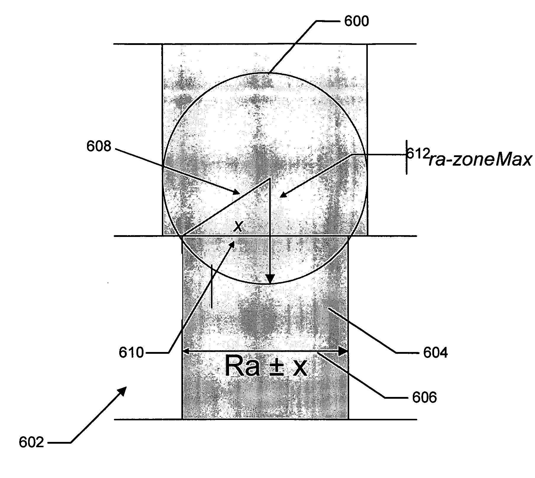
[0051] In general, the system and process according to one embodiment of the present invention identifies all nearby neighbor objects and / or points in relation to a user-specified base point based on information accessed from a database which includes a set of parameters for each object and point. More particularly, this entails first identifying a range of a first pre-selected one of the set of parameters into which that parameter of each of the objects and / or points in the database falls, and then dividing the database into a plurality of zones each forming an equal s...


PUM


Abstract

A system and process is presented that identifies nearby objects and / or points in relation to a base object or point. An object or point is nearby if it resides within a prescribed area around the base point. The identification is based on information accessed from a database of geometric data. The identification of nearby neighbors begins by dividing the geographic system defined by said geometric data into a plurality of zones. The zone in which each object or point resides and the zones intersected by the prescribed area are determined. The nearby objects and / or points of interest are then identified by initially considering only those that are identified as residing in the zones intersected by the prescribed area. The search for nearby neighbors can be further refined by limiting the objects and / or points considered to those with locations within the lateral extent and / or within the height of the prescribed area.

Description

CROSS-REFERENCE TO RELATED APPLICATIONS [0001] This application is a continuation of a prior application entitled “A SYSTEM AND PROCESS FOR IDENTIFYING OBJECTS AND / OR POINTS NEARBY A GIVEN OBJECT OR POINT” which was assigned Ser. No. 10 / 354,200 and filed Jan. 28, 2003.BACKGROUND [0002] 1. Technical Field [0003] The invention is related to systems and processes for identifying objects and / or points nearby a given object or point based on information accessed from a database of geometric data. [0004] 2. Background Art [0005] There are in existence today large electronic databases containing information on objects associated with geometric systems. A very simple example of this is an electronic road map database. This type of database will typically contain information about the location of roads, towns and cities, and numerous other landmarks laid out in a planar geometry. In addition, the database will typically contain information about the landmarks found on the map. There are nume...

Claims


Application Information

Patent Timeline
Patent Type & Authority Applications(United States)
IPC IPC(8): G06F7/00G06F17/30
CPCG06F17/30241Y10S707/99934Y10S707/919Y10S707/99948Y10S707/99945G06F16/29
Inventor GRAY, JAMES N.
Owner UBER TECH INC
Why Eureka
Try Eureka