
Method and apparatus for providing an integrated communications, navigation and surveillance satellite system

a satellite system and integrated technology, applied in the field of global integrated communications, navigation and surveillance satellite systems, can solve the problems of insufficient integrity, reliability or availability of the gps service which is available to the civil community, and the ability of the current gps receiver and the gps satellite to communicate two-way, so as to improve the accuracy of the position determination, improve the accuracy, and increase the accuracy of the devi

Inactive Publication Date: 2006-03-23
MURPHY TIMOTHY A
View PDF13 Cites 12 Cited by
  • Summary
  • Abstract
  • Description
  • Claims
  • Application Information

AI Technical Summary

Benefits of technology

The GCNS system provides enhanced accuracy and robustness for navigation and surveillance, reducing costs by eliminating the need for extensive ground-based networks and enabling self-monitoring and correction of errors, while supporting precise positioning and interference detection.

Problems solved by technology

The current GPS receivers and the GPS satellites are not capable of two-way commuication with each other.
Consequently much of the capability of the GPS (i.e. the Precise Positioning Service or PPS) is not available to Civil users.
Furthermore, even the GPS SPS service which is available to the civil community was not designed with adequate integrity, reliability or availability necessary to support safety of life civil applications.
Furthermore, the SPS includes a relatively low power signal on only a single frequency and is consequently vulnerable to intentional or unintentional interference.
These problems with the integrity and robustness of the civil GPS services are well known in the art.
The ionospheric induced delay in the reception of the SPS signals limits the accuracy of the determination of the position of the GPS receiver and is the largest location dependent error source in the calculation of the position of the GPS receiver.
Therefore, the use of the GPS SPS signals to compute a position of the GPS receiver has limited accuracy and cannot be used for applications requiring a high degree of precision in the determination of the position of the GPS receiver.
Hence SBAS does little or nothing to address the robustness concerns of GPS.
However, the complexity and cost of such a system makes it impractical for most States or regions to consider employing such a system.
Particularly, the cost of the ground based telecommunications network can be very significant.
Also, in order to get good sampling of the ionosphere and a more accurate grid of the errors introduced by the ionosphere, a large number of reference stations are required, which in turn increases the cost of connecting all the reference stations with the ground based telecommunication networks.

Method used


Image

  • Method and apparatus for providing an integrated communications, navigation and surveillance satellite system
  • Method and apparatus for providing an integrated communications, navigation and surveillance satellite system
  • Method and apparatus for providing an integrated communications, navigation and surveillance satellite system

Examples


Embodiment Construction

[0027] The following description of the preferred embodiment(s) is merely exemplary in nature and is in no way intended to limit the invention, its application, or uses.

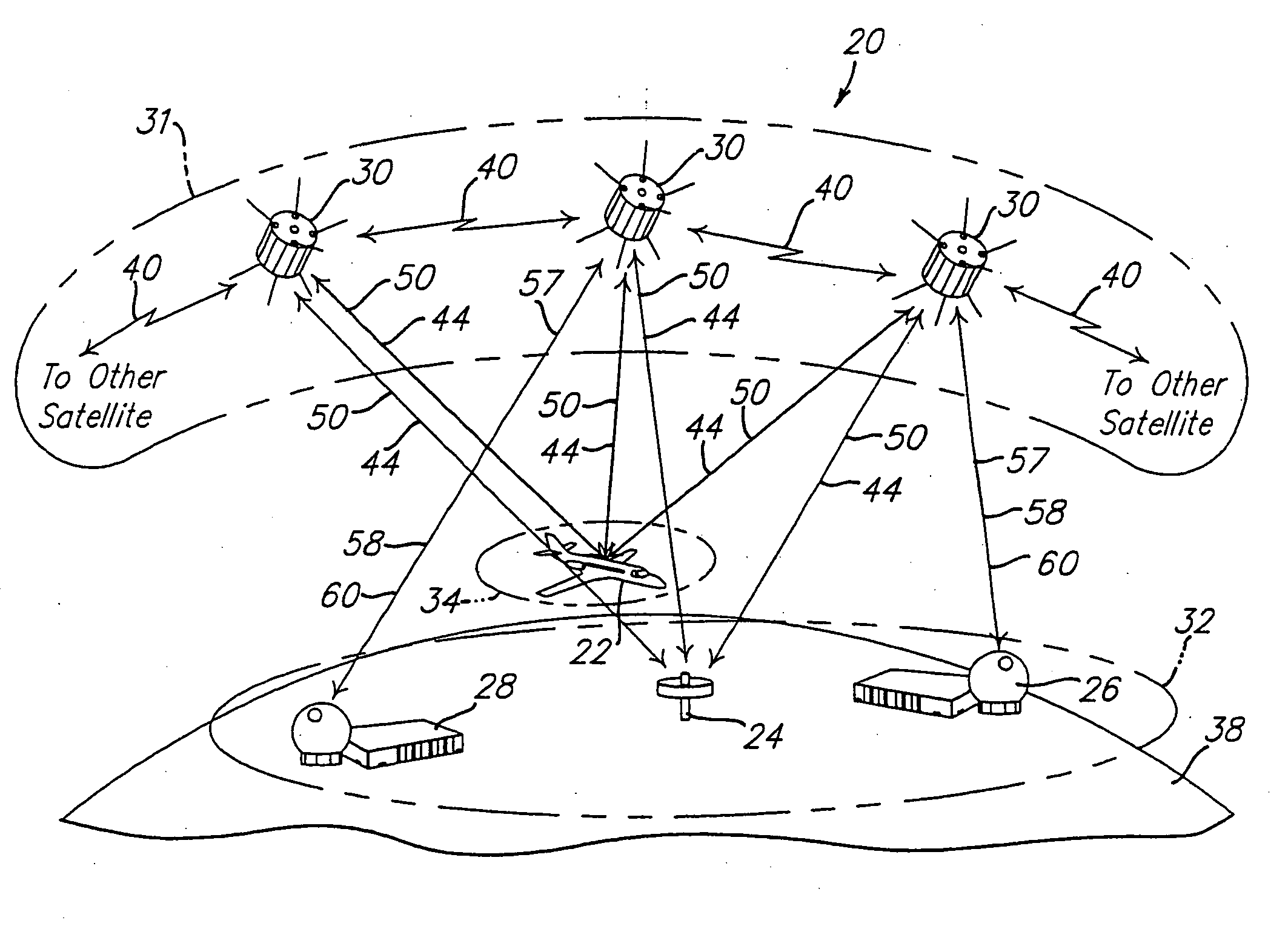
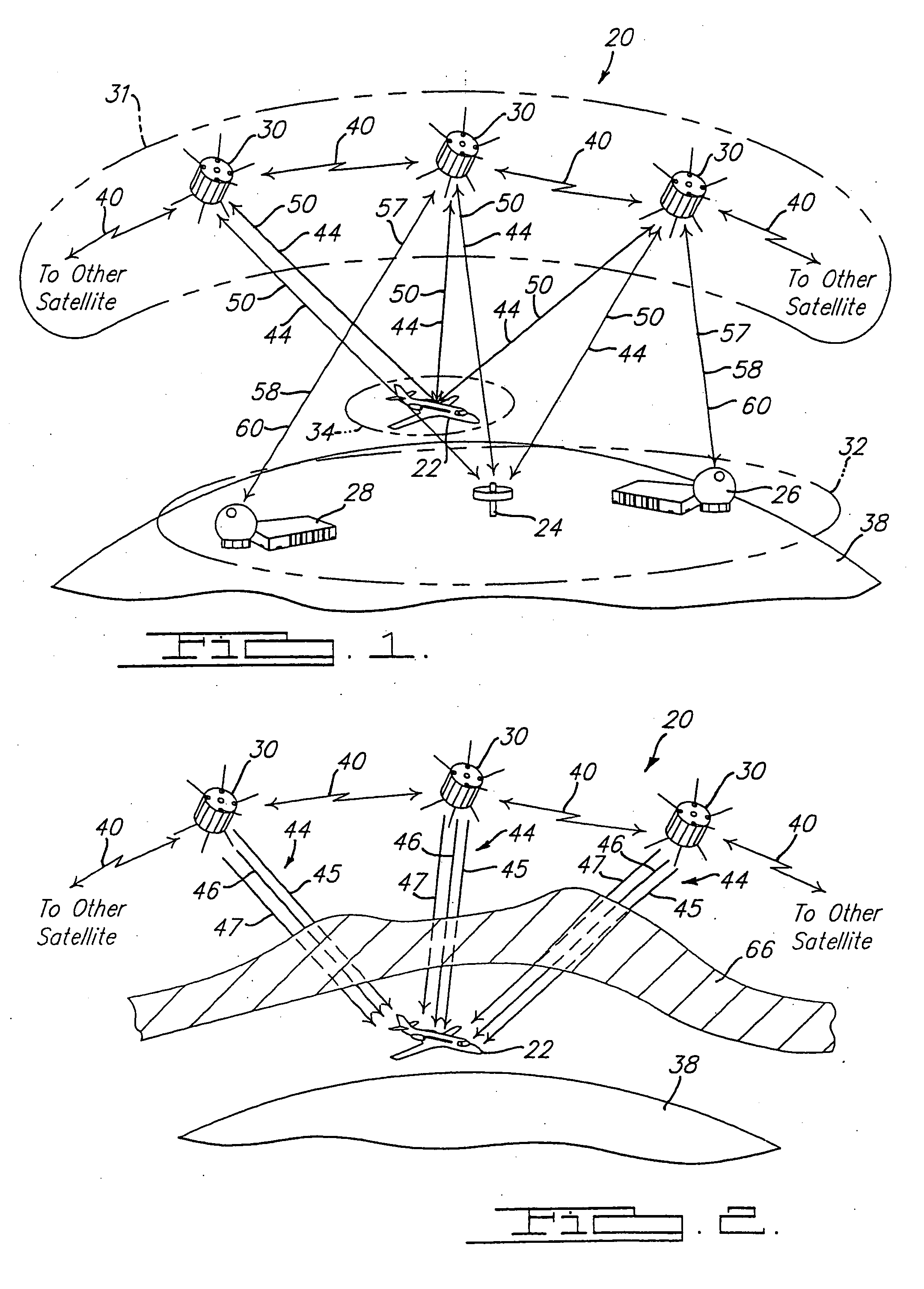
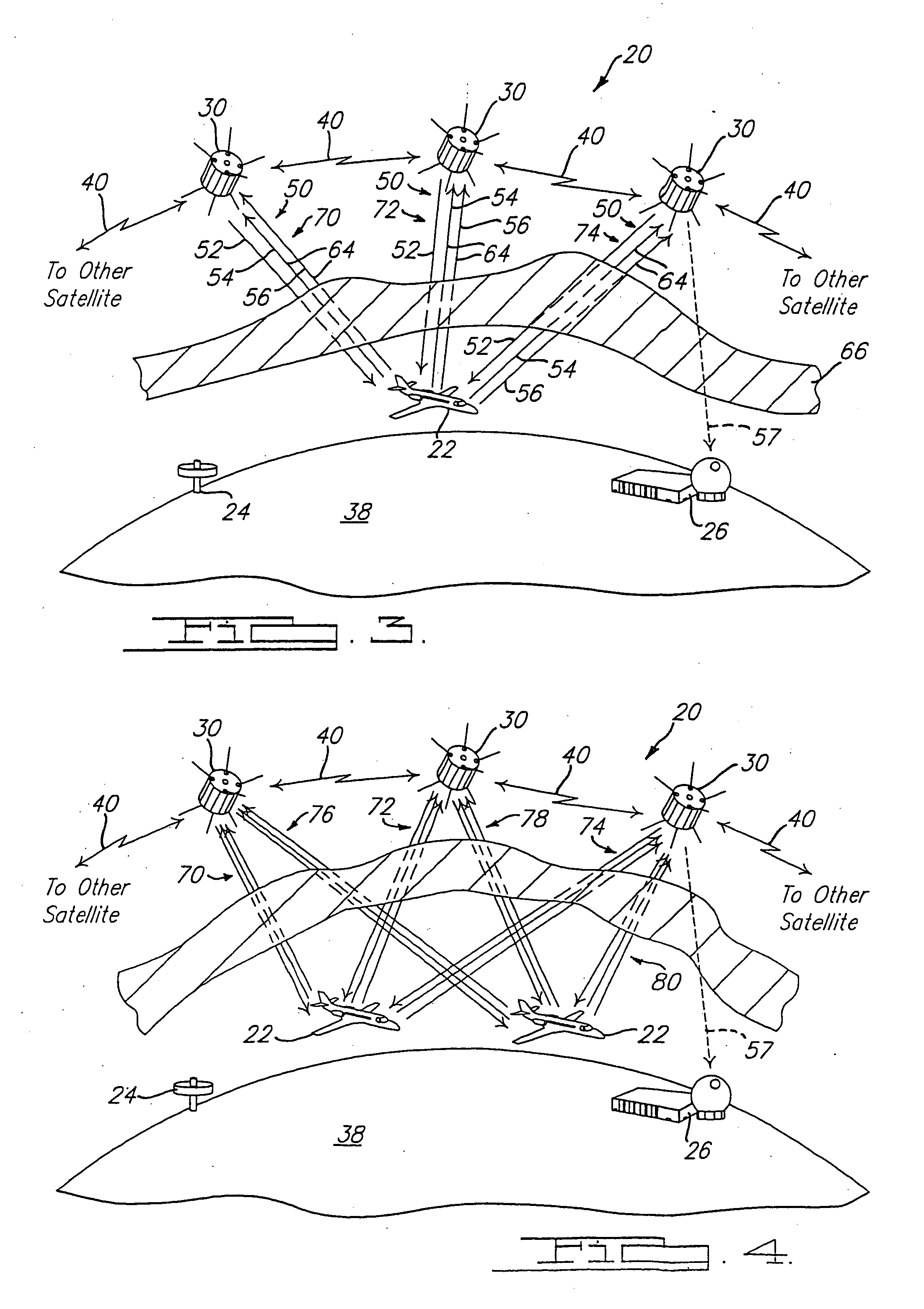
[0028] Referring to FIG. 1, there is shown a GCNS system 20 in accordance with a preferred embodiment of the present invention. The GCNS system 20 provides communications, navigation and surveillance capabilities to and from a mobile user device 22, a monitoring station 24, a master control station (MCS) 26, a satellite network access gateway (SNAG) 28 and / or a plurality of satellites 30. The MCS and SNAG are also referred to as ground stations.

[0029] The GCNS system 20 generally comprises a space segment 31, a terrestrial segment 32, and a user segment 34. The space segment 31 may include any number of satellites 30 needed to provide coverage for any given region of the earth 38 where mobile user devices 22 are expected to be used. Preferably, there are enough satellites 30 so that a user device 22 is within a lin...


PUM


Abstract

A system provides integrated communications, navigation and surveillance capabilities. The system includes a space segment having a plurality of satellites broadcasting multiple navigation signals and a communication signal. A user segment includes a user device that is operable to broadcast communication signals to the satellites and of using the navigation signals broadcast by the satellites to determine a position of the user device. The satellites are operable to receive the communication signals from the user device and determine a position of the user device based upon the received communication signals. The satellites broadcast one of the navigation signals and the communication signal at a same frequency. The navigation signal acts as a pilot tone for the system to acquire and synchronize the user device with the system.

Description

CROSS-REFERENCE TO RELATED APPLICATIONS [0001] This application is a continuation of U.S. patent application Ser. No. 09 / 972,355 filed on Oct. 5, 2001, and now issued as U.S. Pat. No. _____, the disclosure of which is incorporated herein by reference.FIELD OF THE INVENTION [0002] The present invention relates to a global integrated communications, navigation and surveillance satellite system. BACKGROUND OF THE INVENTION [0003] Current satellite systems provide positioning and time information by broadcasting navigation signals to properly equipped users. For example, a the US Global Positioning System (GPS) consists of 24 satellites orbiting the earth twice a day at an altitude of approximately twelve thousand miles, as well as a network of ground stations to monitor and manage the satellite constellation. The GPS satellites transmit continuous Navigation Data and Ranging (NDR) information 24 hours a day toward the earth. A GPS receiver which properly decodes, tracks and interprets ...

Claims


Application Information

Patent Timeline
Patent Type & Authority Applications(United States)
IPC IPC(8): G01S5/14G01S19/38G01S1/00G01S1/04H04B7/185
CPCG01S19/00H04B7/18552H04B7/18508G01S19/38G01S19/01G01S19/02G01S19/39G01S19/071G01S19/072
Inventor MURPHY, TIMOTHY A.
Owner MURPHY TIMOTHY A
Learn More