Geographic information storage, transmission and display system

a technology of transmission and display system and geographic information, applied in traffic control system, navigation instruments, instruments, etc., can solve the problem of encapsulating a vast amount of data that is difficult to transmit and display to users in a timely fashion, and achieve the effect of reducing the amount of high-resolution data

Active Publication Date: 2006-09-21
NORTHROP GRUMMAN SYST CORP
View PDF5 Cites 101 Cited by
  • Summary
  • Abstract
  • Description
  • Claims
  • Application Information

AI Technical Summary

Benefits of technology

[0005] In one embodiment, a relatively low resolution photographic image of a large geographic area is initially displayed to the user, and the user can then select a limited region of the image for closer viewing. The selected limited region of the image may then be downloaded to the user in a higher resolution format, thereby reducing the amount of high resolution data that must be transmitted to the user. Various display devices may be used, such as a personal data assistant (PDA), laptop computer, desktop computer, vehicle-mounted computer, tablet, cell phone and the like. In addition to displaying the desired image, the display device may also be used as the input device to identify the geographic area of interest, e.g., by initially displaying a map of the region from which the specific area of interest is identified. In one embodiment, the photographic image may be overlaid over the map display.

Problems solved by technology

However, such information typically embodies a vast amount of data that is difficult to transmit and display to users in a timely fashion.

Method used


Image

  • Geographic information storage, transmission and display system
  • Geographic information storage, transmission and display system
  • Geographic information storage, transmission and display system

Examples


Embodiment Construction

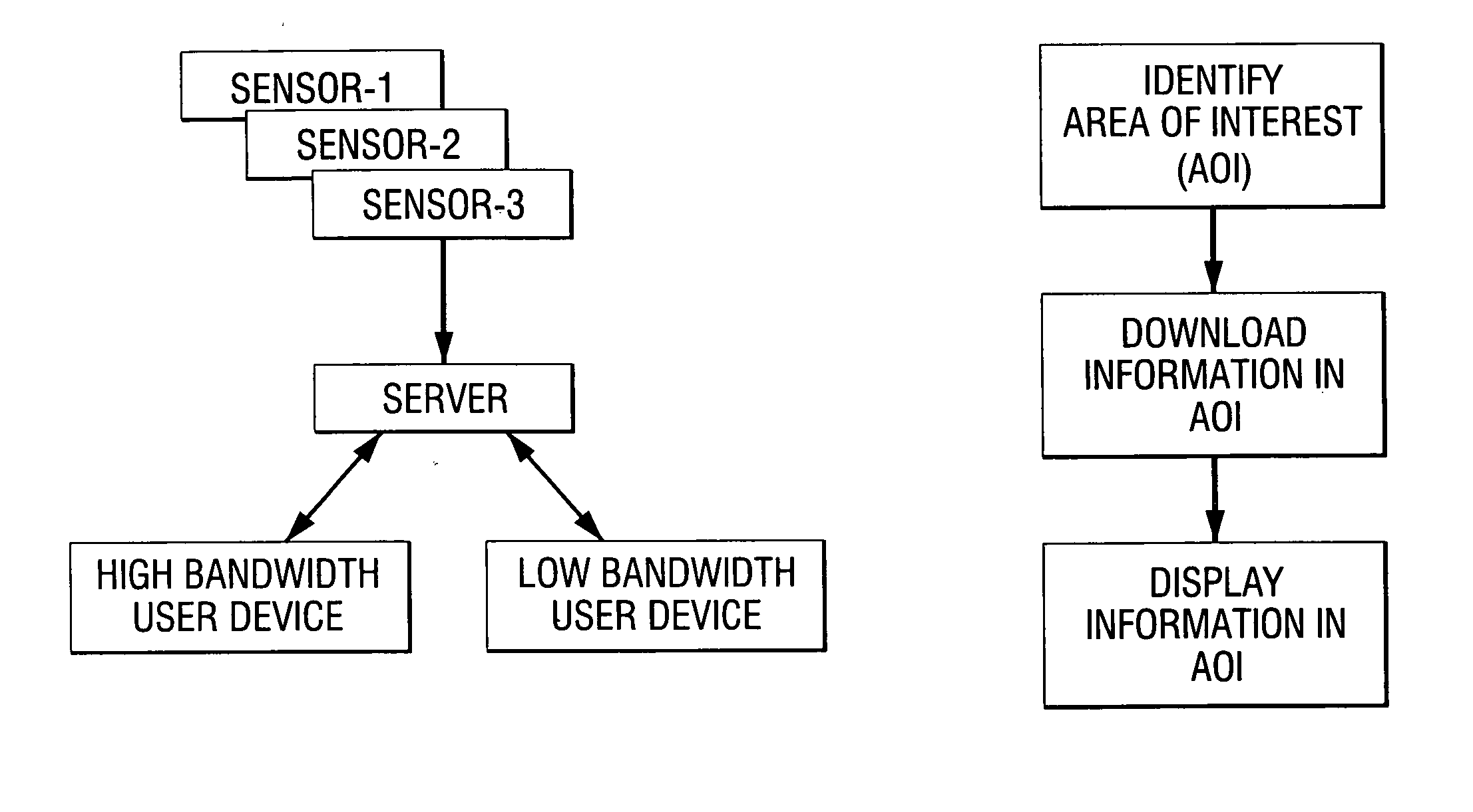
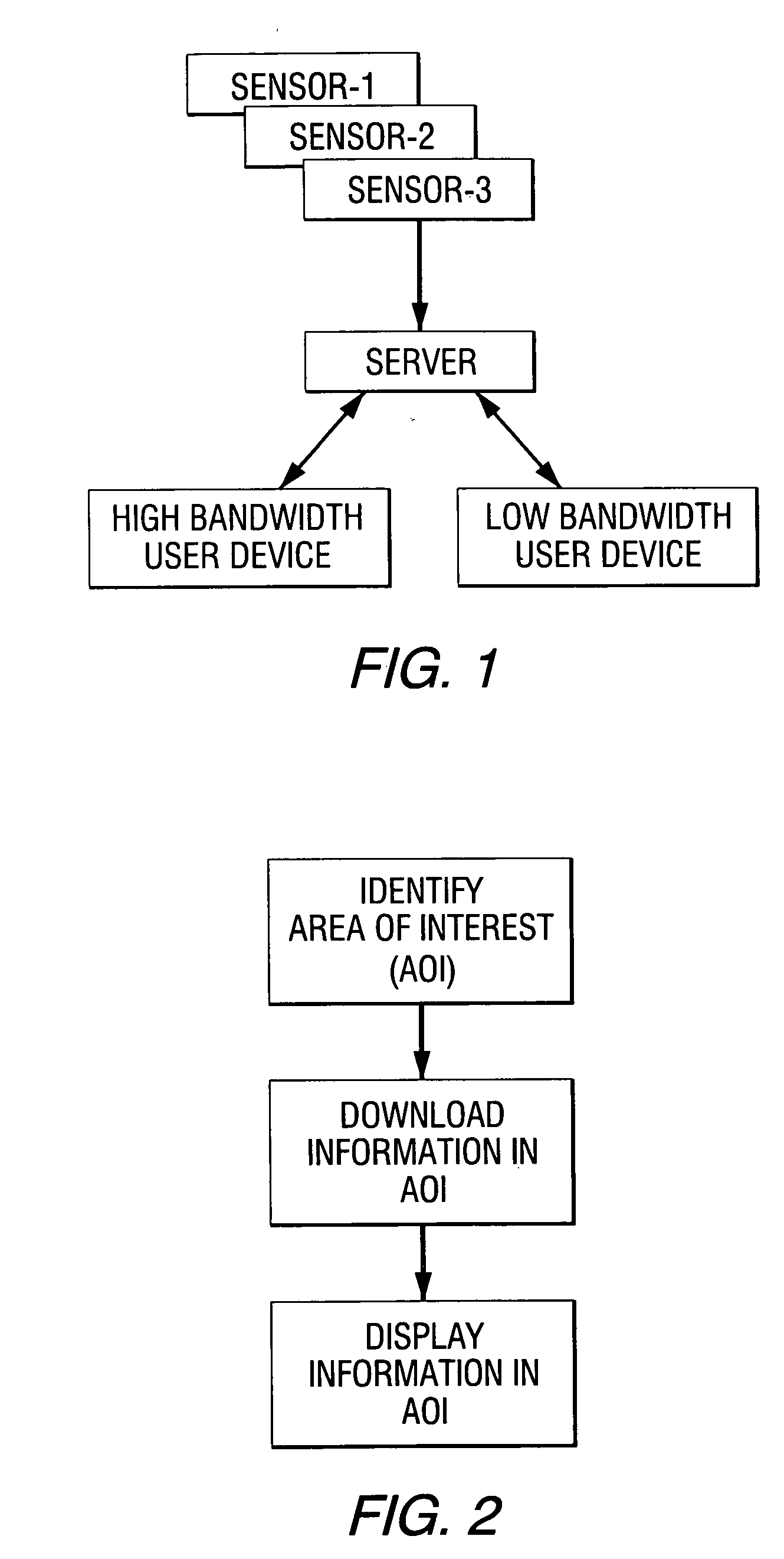
[0021]FIG. 1 schematically illustrates a geographic information storage, transmission and display system in accordance with an embodiment of the present invention. As used herein, the term “geographic information” means information relating to a geographic area, such as photographic images, radar images, radio transmission information, cell phone transmission information, time sequenced images, ground moving target information (GMTI), air moving target information (AMTI), maritime moving target information (MMTI), red or blue force identification and / or potential hazard areas. For example, the geographic information may include photographic images, in which case the images may be captured by an image sensor such as a digital or analog camera. The photographic images may be images taken in the visible region of the electromagnetic spectrum, other wavelengths such as infrared and the like. The image sensor may be mounted on any suitable platform which provides a desirable view of the ...


PUM


Abstract

A system is disclosed in which a geographic area of interest can be selected, and information corresponding to the selected area can be downloaded and displayed by a user in an efficient and timely manner. The geographic area of interest may initially be selected by various input means such as a map, longitude/latitude coordinates, a global positioning system (GPS), and the like. Once the particular geographic area has been selected, geographic information corresponding to the selected area is downloaded to the user. The geographic information may include photographic images, radar, radio transmission, cell phone transmission, time sequenced images, ground moving target information, air moving target information, maritime moving target information, red or blue force identification and/or potential hazard areas information. The geographic information may be stored in a suitable data storage system such as a server. Alternatively, the geographic information may be generated real time and downloaded to the user. In one embodiment, the geographic information includes photographic images and a relatively low resolution image of a large geographic area is initially displayed to the user. The user can then select a limited region of the photographic image for closer viewing. The limited region of the photographic image may then be downloaded to the user in a higher resolution format, thereby reducing the amount of high resolution data that must be transmitted to the user. Various display devices may be used, such as personal data assistants (PDAs), laptop computers, desktop computers, vehicle-mounted computers, tablets, cell phones and the like. The display device may also be used as the input device to both select the geographic area of interest and display the photographic images or other geographic information of the selected area.

Description

FIELD OF THE INVENTION [0001] The present invention relates to a geographic information storage, transmission and display system, and more particularly relates to a system in which a particular geographic area is identified by a user, and information corresponding to that area, such as photographic images, radar images, radio transmission information, cell phone transmission information, time sequenced images, ground moving target information (GMTI), air moving target information (AMTI), maritime moving target information (MMTI), red or blue force identification and / or potential hazard areas, is downloaded to the user via an input / output device. BACKGROUND INFORMATION [0002] Photographic images of various geographic regions are available from sources such as aircraft and satellite-mounted cameras. Other information relating to geographic regions may also be obtained, such as radar images, radio transmission information, cell phone transmission information, time sequenced images, mov...

Claims


Application Information

Patent Timeline
Patent Type & Authority Applications(United States)
IPC IPC(8): G08G1/123G06F17/30
CPCG01C21/00G01C21/20G09B29/10G01C21/3896G01C21/3878G01C21/3889
Inventor POOR, JEFFREYMOS, MICHAELBURTON, DALEMITCHELL, ROBERTDUFFEY, CHRISTOPHER
Owner NORTHROP GRUMMAN SYST CORP
Why Eureka
Try Eureka