GPS device and method for displaying weather data

a technology of weather data and gps, which is applied in the field of hand-held electronic navigation and travel aids, can solve the problems of inability to accurately overlay data, inability to meet the needs of users, etc., and achieves the effects of convenient use, accurate overlaying, and reduced cos

Inactive Publication Date: 2006-10-12
BUSHNELL
View PDF9 Cites 47 Cited by
  • Summary
  • Abstract
  • Description
  • Claims
  • Application Information

AI Technical Summary

Benefits of technology

[0013] As mentioned, the weather data is preferably geo-referenced so that it can be displayed in conjunction with the location data. Thus, the weather data can be accurately overlayed onto street maps, topographic maps, aerial photographs, satellite photographs, and other geo-referenced images. The present invention preferably allows for larger scales than are normally needed for displaying navigation data on a GPS device in order to accommodate weather data with relatively large maximum resolutions and to display developing weather patterns that are more than a relatively short distance away from the user's current location.
[0014] Thus, it will be appreciated that the GPS device and method of the present invention provide a number of substantial advantages over the prior art, including, for example, allowing a user to access weather data while in the field, including detailed information regarding current and forecasted severe weather conditions that might pose a threat to the user's safety. This feature is fully adapted for and integrated into the GPS device, making it a less expensive, more rugged, more portable, and generally more appropriate and practical solution than is provided for by the prior art.

Problems solved by technology

Unfortunately, this solution requires a hard or wireless (e.g., wifi or gprs) connection to access the Internet, and special software running on a desktop computer, laptop computer, or personal digital assistant (PDA) to read the weather data.
Such access and computing power is typically not available or not practical in the field, particularly for those traveling on foot.
Unfortunately, this solution suffers from a number of problems and disadvantages as well, including, for example, that the PDA is an undedicated broadly capable portable computing device which is typically relatively expensive to own and operate.
Furthermore, PDAs are not designed for and may not survive use in relatively harsh operating conditions (e.g., physical shock or impact; dust or other particulate matter; rain or other moisture or even submersion; and extreme hot or cold temperatures), which can be of particular concern given their substantial cost.
The prior art's reliance on external peripheral receiver devices, which are themselves bulky and expensive, is therefore not appropriate or practical for use in harsh operating conditions or use while on the move.

Method used


Image

  • GPS device and method for displaying weather data
  • GPS device and method for displaying weather data
  • GPS device and method for displaying weather data

Examples


Embodiment Construction

, below.

BRIEF DESCRIPTION OF THE DRAWINGS

[0016] A preferred embodiment of the present invention is described in detail below with reference to the attached drawing figures, wherein:

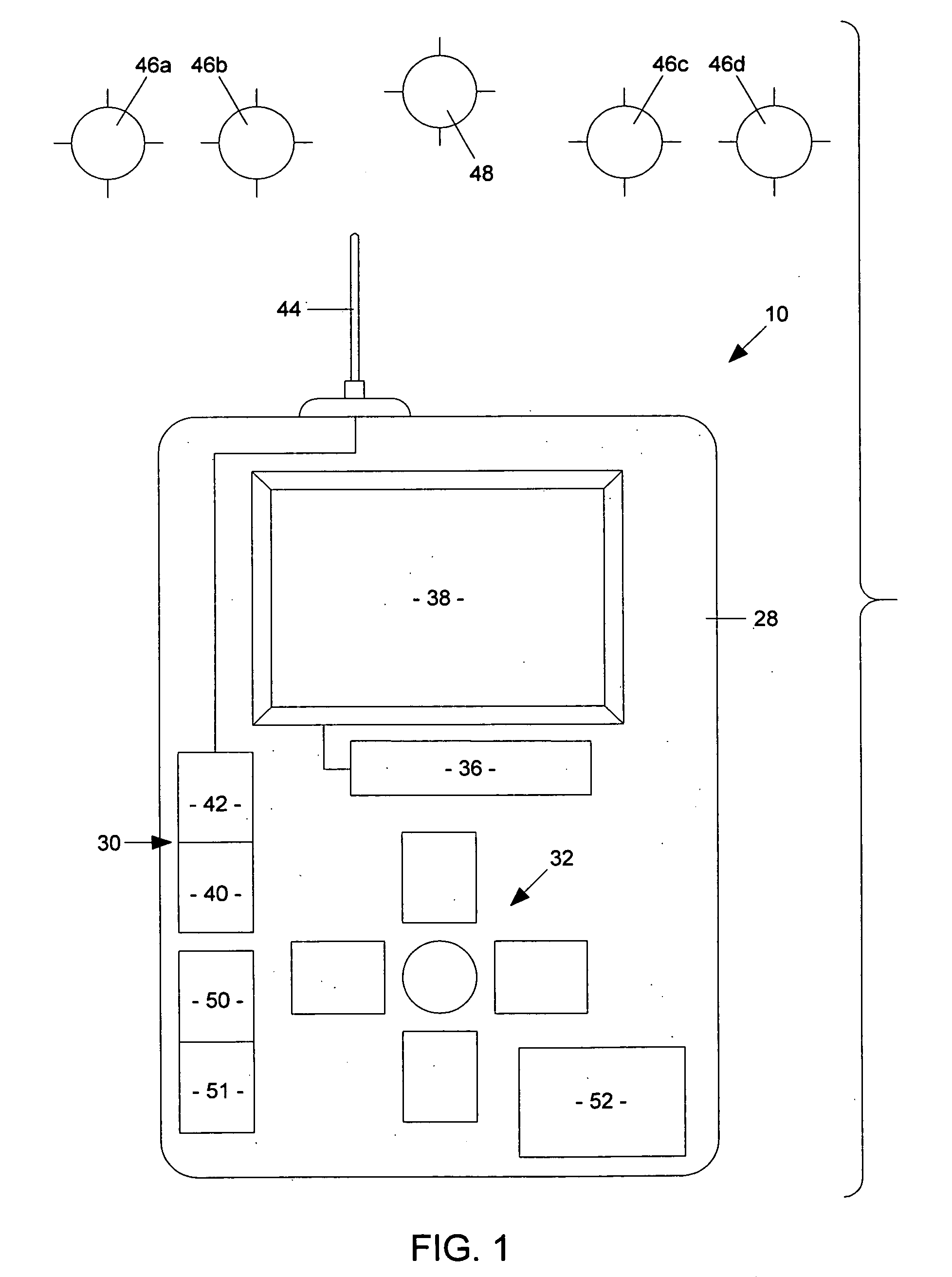
[0017]FIG. 1 is a block-diagram depiction of a preferred embodiment of a GPS device of the present invention;

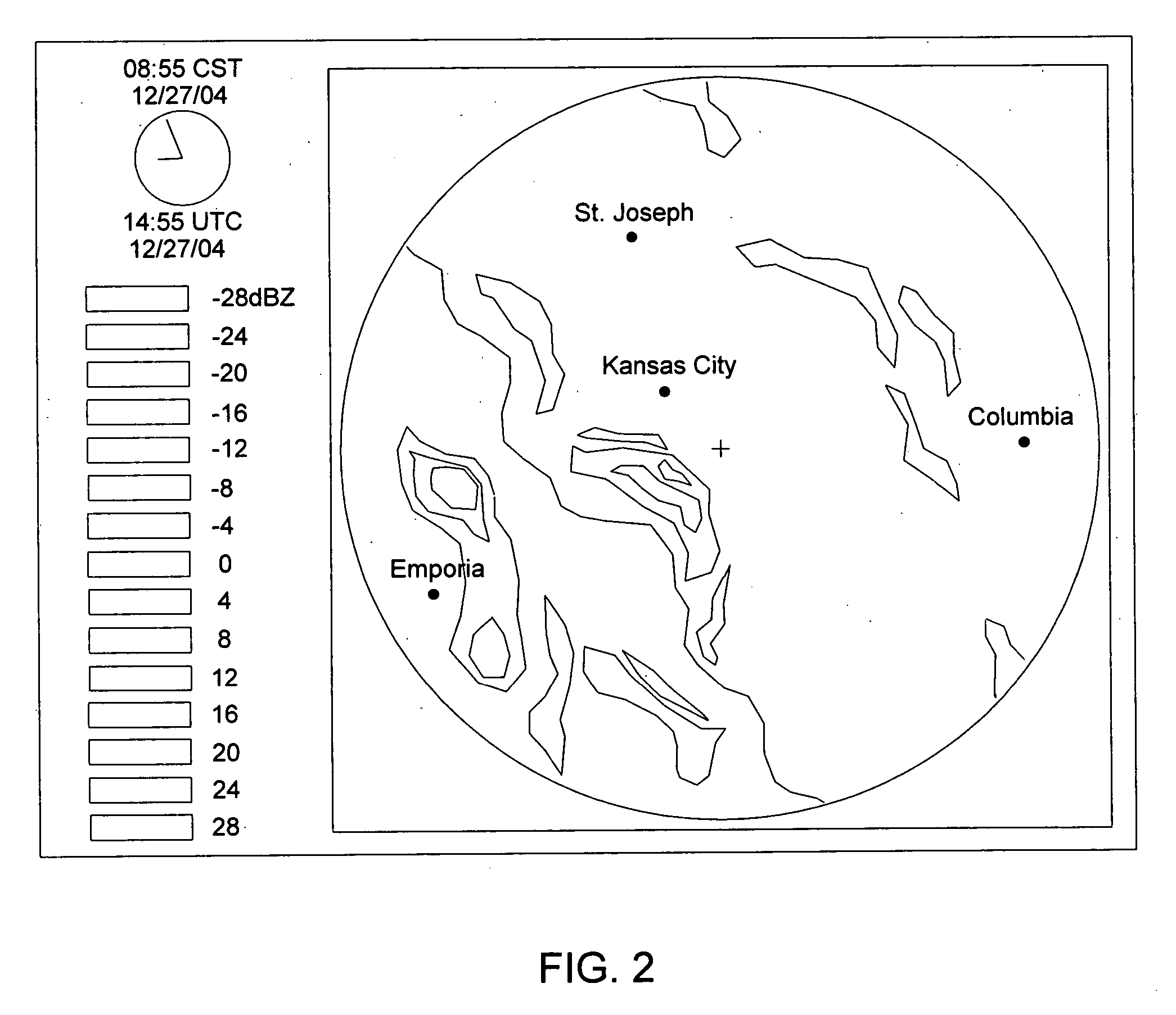
[0018]FIG. 2 is a depiction of weather data displayed on a relatively large scale;

[0019]FIG. 3 is a depiction of weather data and location data displayed on a relatively small scale; and

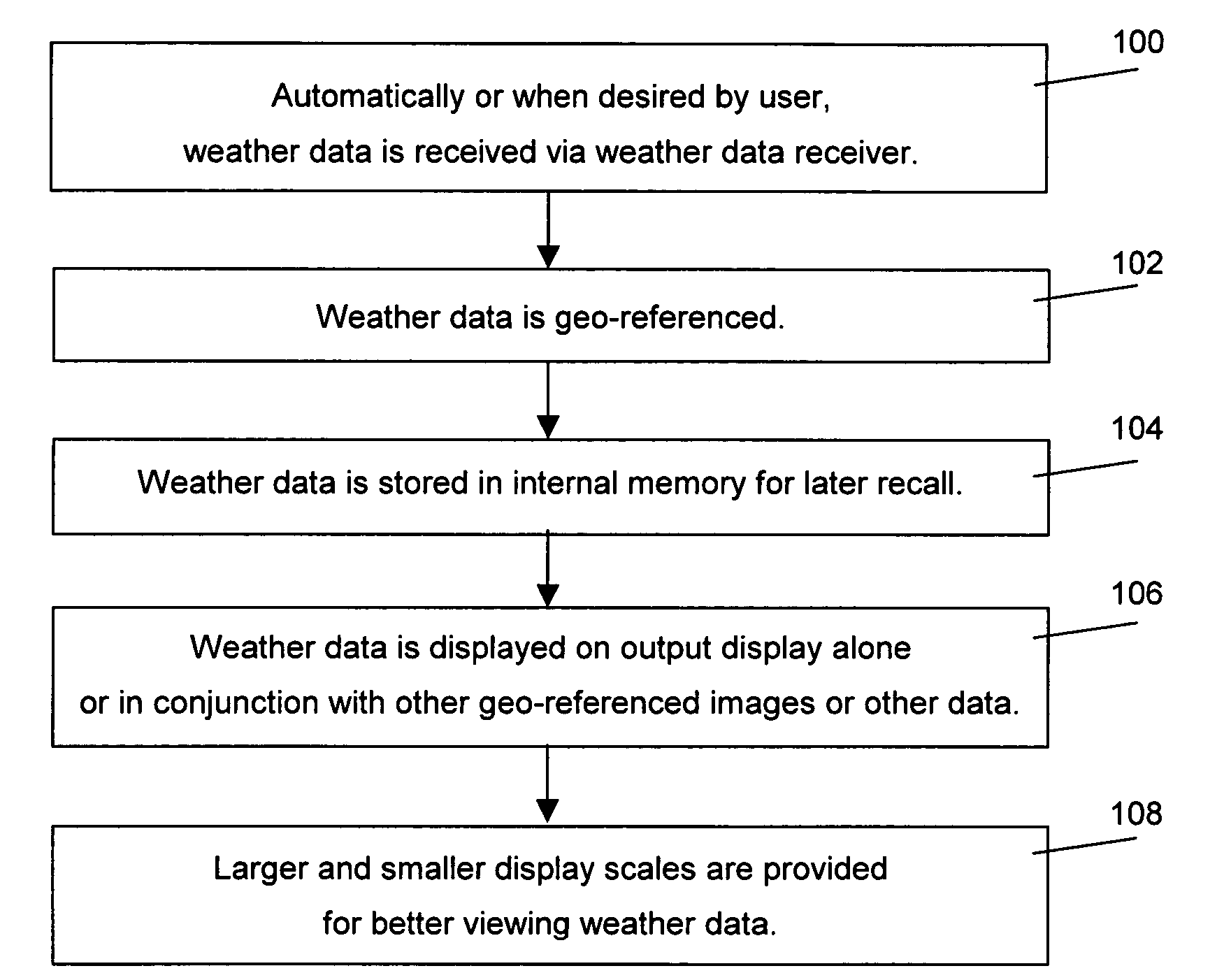
[0020]FIG. 4 is a flowchart of steps involved in operation of the GPS device of FIG. 1.

DETAILED DESCRIPTION OF THE PREFERRED EMBODIMENT(S)

[0021] With reference to the figures, a GPS device 10 and method are herein described, shown, and otherwise disclosed in accordance with the preferred embodiment(s) of the present invention. More specifically, the present invention concerns a GPS device 10 and method for associating current and forecasted geo-referenced weather data, both in static and animated formats, wit...


PUM


Abstract

A GPS device and method for associating current and forecasted geo-referenced weather data with location data in a hand-held ruggedized GPS device having an integrated weather data receiver, wherein the weather data can be displayed alone, particularly on larger scales, or in conjunction with the location data.

Description

BACKGROUND OF THE INVENTION [0001] 1. Field of the Invention [0002] The present invention relates broadly to hand-held electronic navigation and travel aids. More particularly, the present invention concerns a GPS device and method for associating current and forecasted geo-referenced weather data with location data in a hand-held ruggedized GPS device having an integrated weather data receiver, wherein the weather data can be displayed alone, particularly on larger scales, or in conjunction with the location data. [0003] 2. Description of the Prior Art [0004] Outdoor enthusiasts, such as sportsmen, vacationers, and athletes, increasingly use hand-held electronic global positioning system (GPS) devices to navigate while afield. Commonly-available GPS devices typically include at least a processor, a receiver, and an antenna for receiving position signals from a plurality of known locations (e.g., from satellites in orbit) and, through a process of geometric triangulation, determinin...

Claims


Application Information

Patent Timeline
Patent Type & Authority Applications(United States)
IPC IPC(8): G01C21/00
CPCG01C21/20G01W1/10G01W1/02G01S19/20
Inventor CROSS, JOHNNYHART, SCOTTBALL, RICHARDDECASTRO, JOHN
Owner BUSHNELL
Why Eureka
Try Eureka