Road precursory and vehicle trip recording method of navigation system

a technology of navigation system and precursory vehicle, which is applied in the direction of navigation instruments, process and machine control, instruments, etc., can solve the problems of insufficient information related to rear side services, traffic accidents, and risks of the above-mentioned system

Inactive Publication Date: 2006-11-16
IND TECH RES INST
View PDF4 Cites 6 Cited by
  • Summary
  • Abstract
  • Description
  • Claims
  • Application Information

AI Technical Summary

Benefits of technology

[0009] To achieve these objectives of the present invention, the road precursory and vehicle trip recording method of the present invention employs a GPS and an inertial measurer to access respectively the present coordinate point and driving direction of the car in an electronic map, defines a comparative coordinate point by using an estimated distance before the present coordinate point of the vehicle, and compares the present speed of the vehicle with a predetermined safety vehicle speed of the comparative coordinate point set in an electronic map so as to transmit precursory signals once the present speed of the car exceeds the safety speed, thereby preventing the vehicle driver from danger resulted from fatigue or carelessness. In addition, the actual speed, the turning angle of the steering wheel, and the GPS coordinate points and time will be fully recorded during driving.

Problems solved by technology

Providing the car driver with wrong information may result in a traffic accident.
Because of imperfect calculation method, the aforesaid system runs risks.
Further, current navigation systems provide sufficient information related to front side services such as vehicle traveling direction and vehicle speed limit, however the information related to rear side services is insufficient.

Method used


Image

  • Road precursory and vehicle trip recording method of navigation system
  • Road precursory and vehicle trip recording method of navigation system
  • Road precursory and vehicle trip recording method of navigation system

Examples


Embodiment Construction

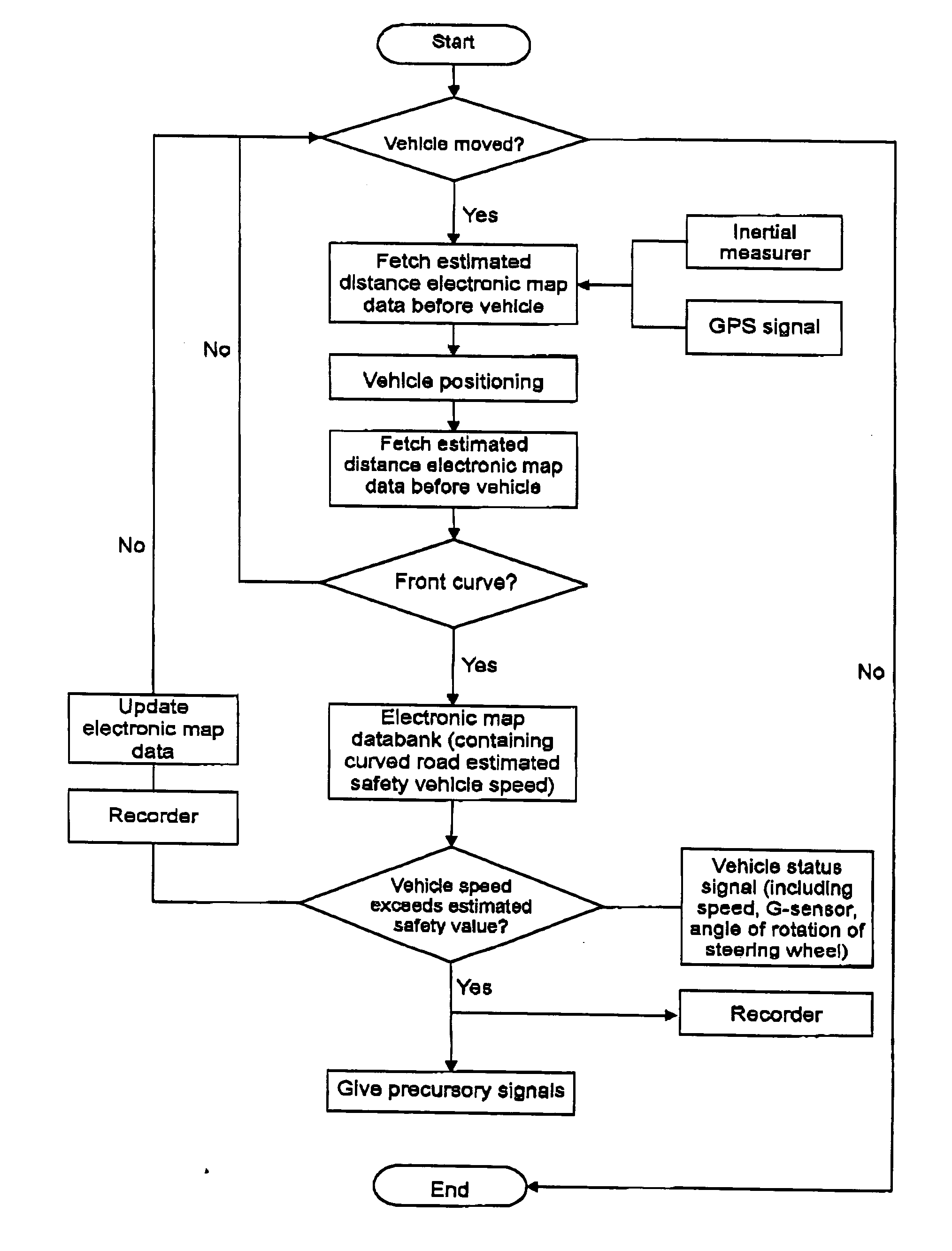
[0020] A road precursory and vehicle trip recording method in accordance with the present invention includes two parts, namely the road precursory procedure and the vehicle traveling recording procedure.

[0021] The road precursory procedure includes steps 1 through 7. The first step is to establish an electronic map data, which includes the sub-steps of:

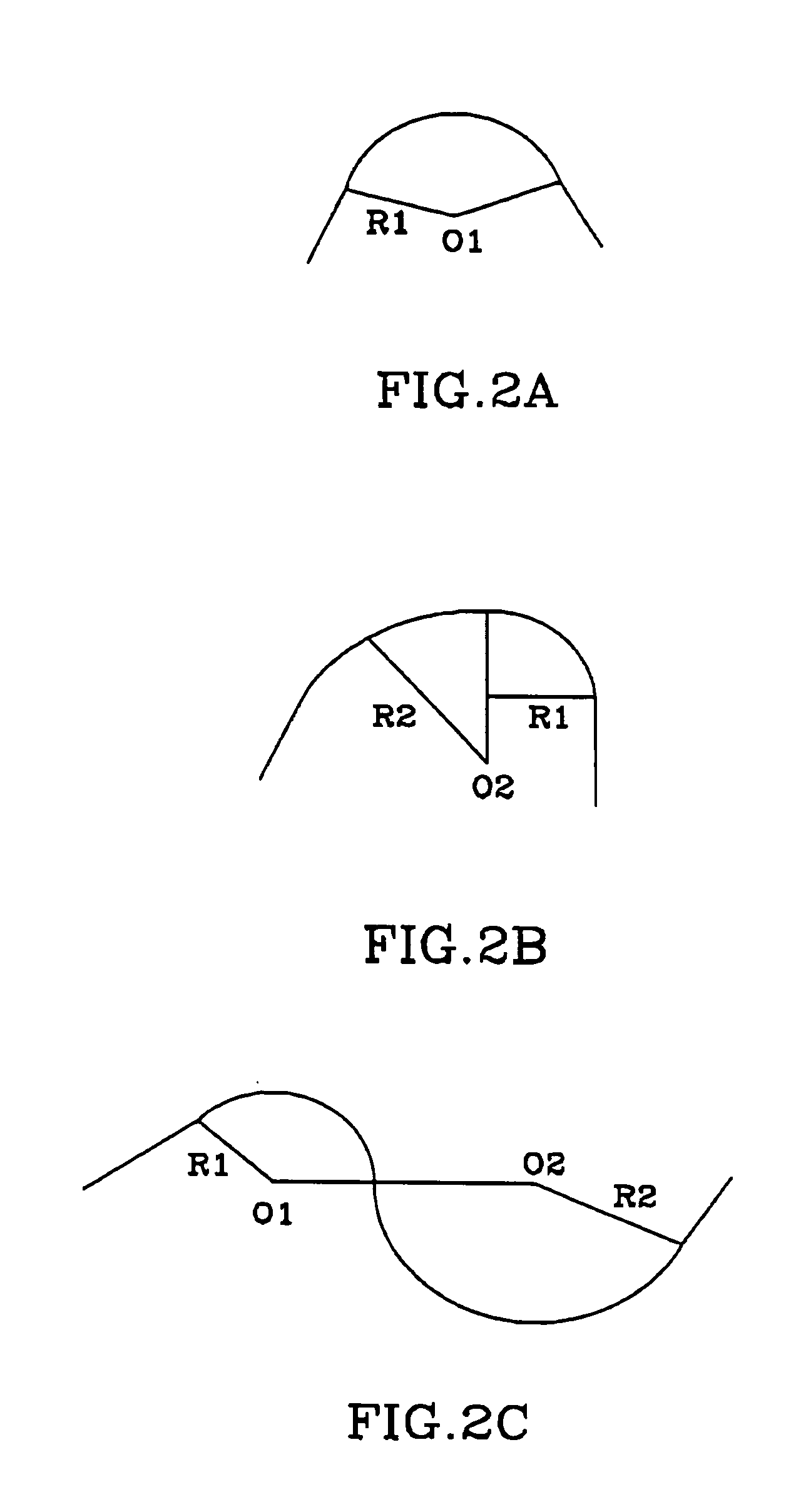
[0022] (a) defining all the roads in the electronic map to be a combination of a single curve as shown in FIG. 2A, a multi-curve as shown in FIG. 2B, or a reverse curve as shown in FIG. 2C;

[0023] (b) defining the weight of the vehicle, and defining the average outer line elevation of the roads on every coordinate point and road surface μ value subject to road construction design regulations;

[0024] (c) selecting a number of points from every road in the electronic map, for example, selecting 18 points from the example road section as shown in FIG. 3, i.e., S0 through S17, and then calculating the contained angle of two adjacent tra...


PUM


Abstract

A road precursory and vehicle trip recording method of a navigation system employs a GPS and an inertial measurer to access respectively the present coordinate point and driving direction of the car in an electronic map, defines a comparative coordinate point by using an estimated distance before the present coordinate point of the vehicle, and compares the present speed of the vehicle with a predetermined safety vehicle speed of the comparative coordinate point set in an electronic map so as to transmit precursory signals once the present speed of the vehicle exceeds the predetermined safety vehicle speed, thereby preventing the vehicle driver from danger resulted from fatigue or carelessness. In addition, the actual speed, the turning angle of the steering wheel, and the GPS coordinate points and time will be fully recorded during driving.

Description

BACKGROUND OF THE INVENTION [0001] 1. Field of the Invention [0002] The present invention relates to a navigation system and more specifically, to a road precursory and vehicle trip recording method of a navigation system. [0003] 2. Description of the Related Art [0004] In traffic transportation, more and more users rely upon a navigation system to guide the route and locations. Early navigation systems provide road information by means of images without giving a guide to the conditions of front roads. These navigation systems simply provide information related to the driving direction, having little navigation value. [0005] Recently, new navigation systems provide improved functions, giving sufficient information about the conditions of front roads. For example, an advanced navigation system can provide a guide to legal limit vehicle speed, picking up the images of the intersection of front roads and displaying the images in an enlarged scale, giving a signal of approaching of the ...

Claims


Application Information

Patent Timeline
Patent Type & Authority Applications(United States)
IPC IPC(8): G01C21/00
CPCG01C21/3697G01C21/26
Inventor CHIEN, CHANG-CHUNSHU, PING-HUEIHUANG, LI-KUNGCHEN, LONG-TAI
Owner IND TECH RES INST
Why Eureka
Try Eureka