Method and apparatus for accessing spatially associated information

a technology of spatial association and information, applied in the field of information stored and accessed, can solve the problems of not being useful in fine identification of objects, document information is not very informative, and printed information is generally not kept up to date, so as to facilitate manipulation of various functions, easy to aim, easy to aim

Inactive Publication Date: 2006-11-16
OUTLAND RES
View PDF99 Cites 71 Cited by
  • Summary
  • Abstract
  • Description
  • Claims
  • Application Information

AI Technical Summary

Benefits of technology

[0028] Also, in another embodiment, the portable computing device is equipped with a finger controllable roller to provide easier manipulation of the various functions associated with the embodiment.
[0029] Yet, in another embodiment, a video camera is incorporated into the device to capture an image of the distant objects and allow the user to more easily aim the portable computing device a distant location. In some such embodiments a cross-hairs or other visual indicator is used upon the displayed camera image

Problems solved by technology

The problem with such systems is that a user often wants to gain information about a location that they are not local to, but which is off in the viewable distance to that user.
However, these documents are not very informative because they contain limited amounts of information and are generally not useful on the fine identification of objects such as specific trees and plants.
Also such printed information is generally not kept up to date as well as on-line information.
This lack of information often results in ineffective advertising for businesses and limited scientific information about natural phenomenon.
For example, on a traditional map or brochure covering a city, business are not be able to provide the consumer with a list of products sold in a particular store nor can businesses indicate products that are currently on sale or otherwise featured.
Similarly, a local historical building may not be able to provide the public with detaile

Method used


Image

  • Method and apparatus for accessing spatially associated information
  • Method and apparatus for accessing spatially associated information
  • Method and apparatus for accessing spatially associated information

Examples


Embodiment Construction

[0041] The following description is not to be taken in a limiting sense, but is made merely for the purpose of describing the general principles of exemplary embodiments. The scope of the invention should be determined with reference to the claims.

Overview

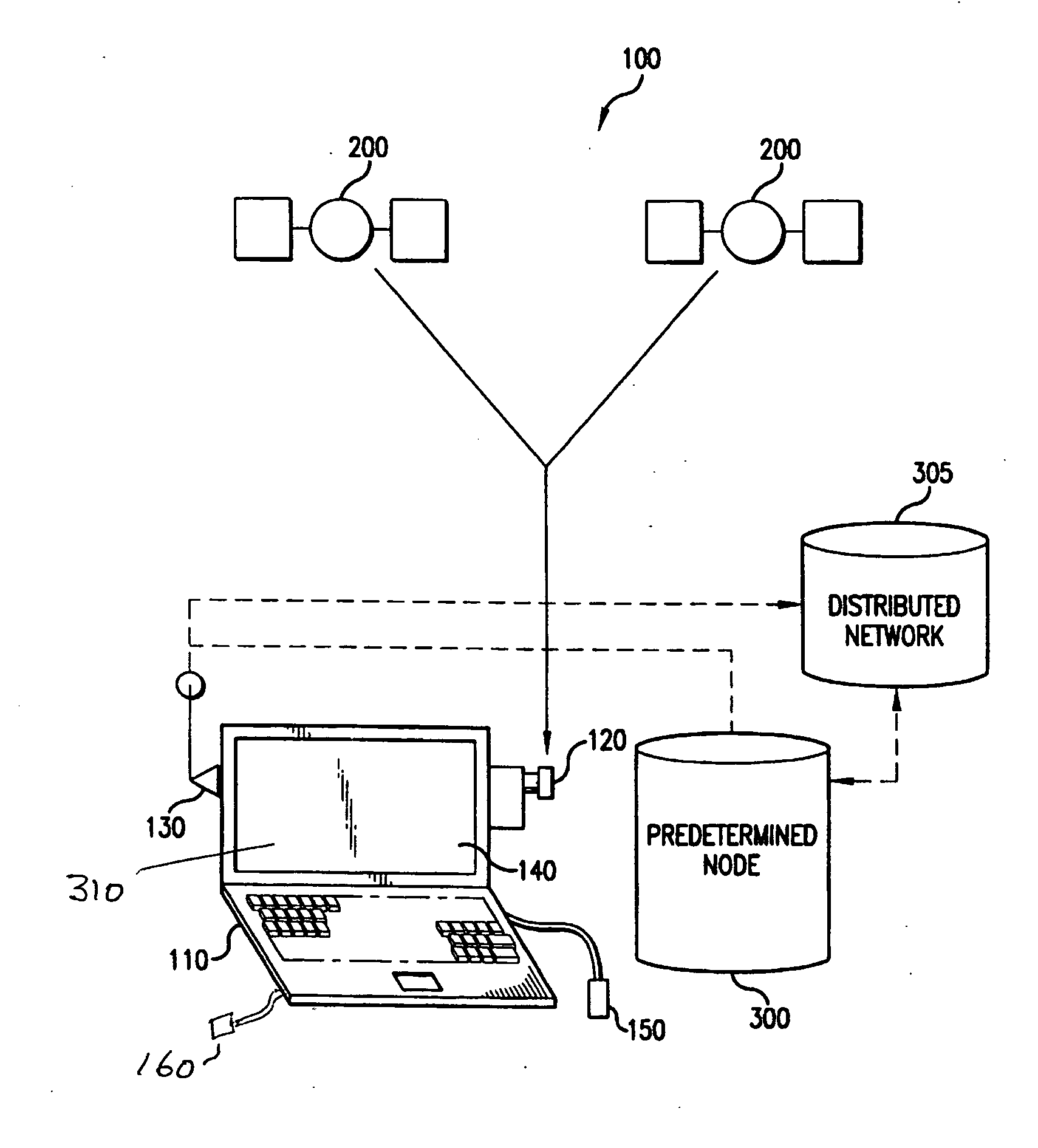
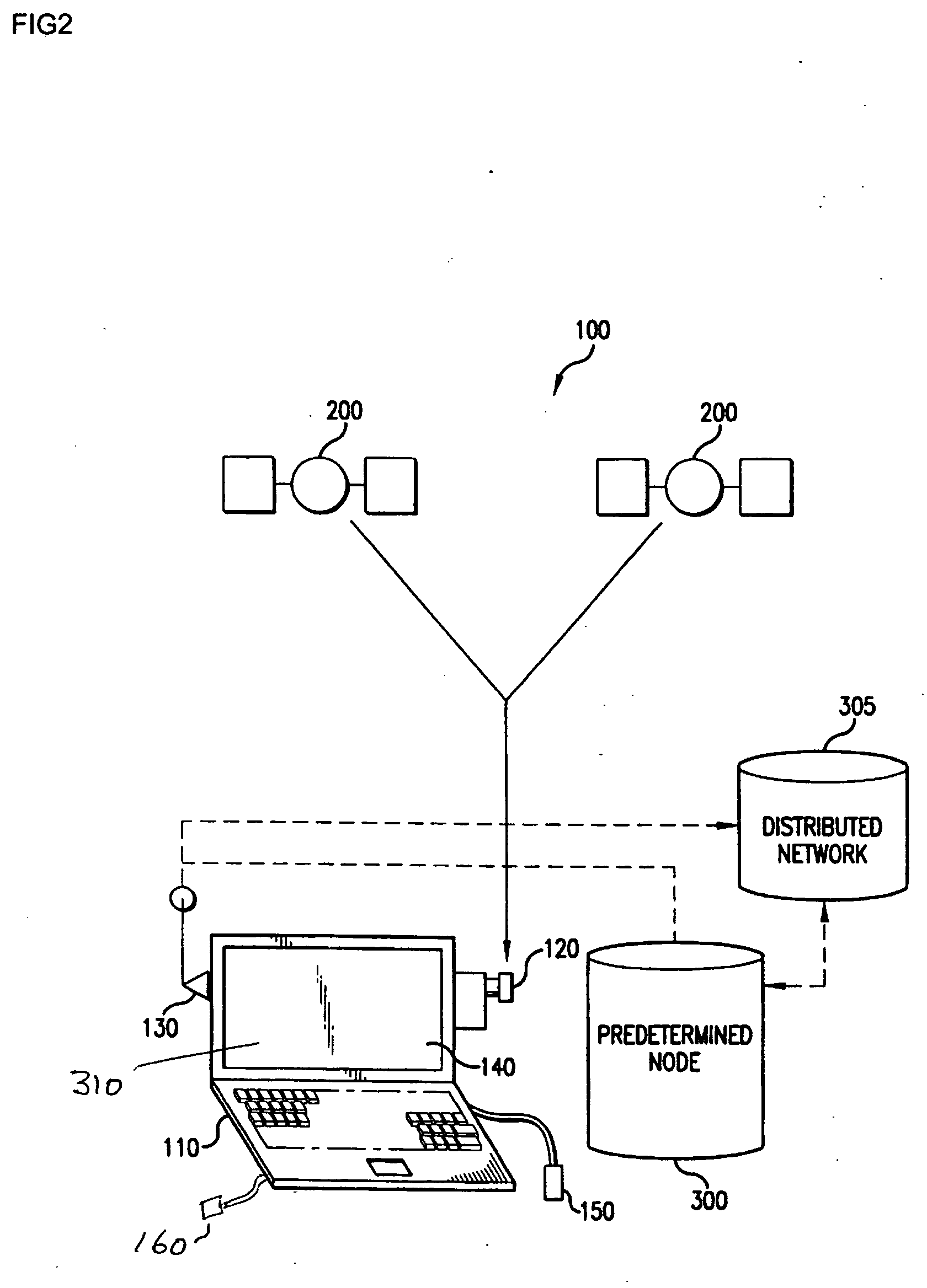
[0042] The current invention in various embodiments enables a user to access information associated with a distant spatial location (or range of locations) by pointing a handheld computing device at that distant location (or range of locations). Various embodiments employ a portable computing device interfaced with a positioning system such as the Navstar Global Positioning System (GPS) in combination with a distributed network, such as the Internet, to provide real-time location specific information to a user. Such embodiments include a wireless transceiver for communicating to the distributed network. The GPS sensor generates a coordinate entry that relates to the then current location of the portable computing device. A uniqu...


PUM


Abstract

A targeting location information system uses a portable computing device interfaced with a positioning system in combination with a distributed network. Targeting methods and apparatus are then used to identify a user selected location that is some distance away from the then current location of the portable computing device, the targeting methods allow the user of said portable computing device to target a specific distant location or a range of specific distant locations that is a particular distance and orientation away from said then current location of the portable computing device. Target location coordinates for a specific or range of distant locations is then transmitted to the distributed network and is used in the retrieval of corresponding location specific information. Additional information may be associated with the web page information such as priority information, object type information, context type information, or weighting information. The web page information associated with said location coordinates may then be displayed, optionally contingent upon said priority information, context type information, object type information, or other conditional information.

Description

[0001] This application claims the benefit of U.S. Provisional Application No. 60 / 680,699, filed May 13, 2005 which is incorporated in its entirety herein by reference.BACKGROUND [0002] 1. Field of the Invention [0003] This invention relates generally to the field of information stored and accessed based upon geographic locations. [0004] 2. Discussion of the Related Art [0005] Some basic ideas for information stored and accessed based upon geographic locations are described in the paper by Spohrer entitled Information in Places and published in IBM Systems Journal, vol. 38, No. 4, 1999 (p. 602-628) which is hereby incorporated by reference. [0006] A number of systems have been developed for accessing location related information, said location related information being accessed based upon the then current location of said portable computing system as determined by one or more Global Positioning System (GPS) sensor local to a computing system. For example, U.S. Pat. No. 6,122,520 (20...

Claims


Application Information

Patent Timeline
IPC IPC(8): G06F15/16
CPCH04L67/18H04L67/04H04L67/52
Inventor ROSENBERG, LOUIS B.
Owner OUTLAND RES
Why Eureka
Try Eureka