
Method and system for geospatially enabling electronic communication protocols

Inactive Publication Date: 2007-04-19
SPADAC
View PDF8 Cites 25 Cited by
  • Summary
  • Abstract
  • Description
  • Claims
  • Application Information

AI Technical Summary

Benefits of technology

[0009] The present invention addresses the aforementioned issues and others with current electronic communication protocols by attaching geospatial data to a protocol, routing data between electronic communication devices using this attached geospatial data, and providing algorithms that allow processing and filtering of information based on the attached geospatial data. This system improves performance and response time for spatial data processing by performing processing at the lowest level possible, and provides a solution that can be easily scaled by adding additional routing at intermediate spatial hierarchy levels.

Problems solved by technology

One of the shortcomings of current protocols is that they do not provide geospatial data routing information except in the most limited sense.
For example, two-letter top-level Internet domain names indicate the country involved, but this information is not specific and does not always accurately represent the physical location of the participating communication device.
The lack of consistent and accurate geospatial information for electronic communication data prevents several useful functions, such as, for example: looking up devices by a spatial area of interest (AOI); broadcasting information to all or a filtered set of devices in an AOI; collecting information for an AOI and archiving, querying, reporting, or aggregating the information; and triggering actions based on the physical location of a device.

Method used


Image

  • Method and system for geospatially enabling electronic communication protocols
  • Method and system for geospatially enabling electronic communication protocols
  • Method and system for geospatially enabling electronic communication protocols

Examples


Embodiment Construction

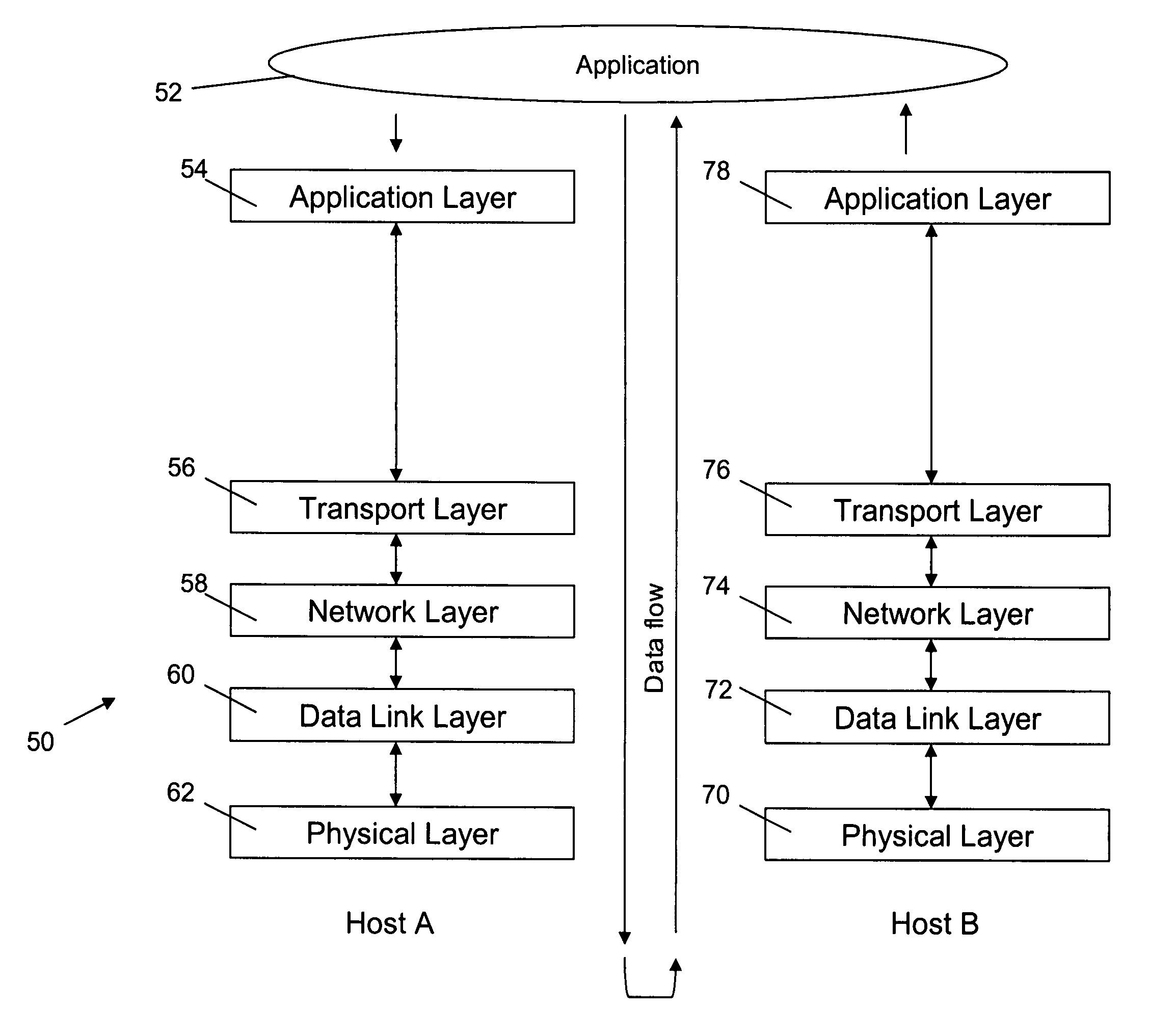
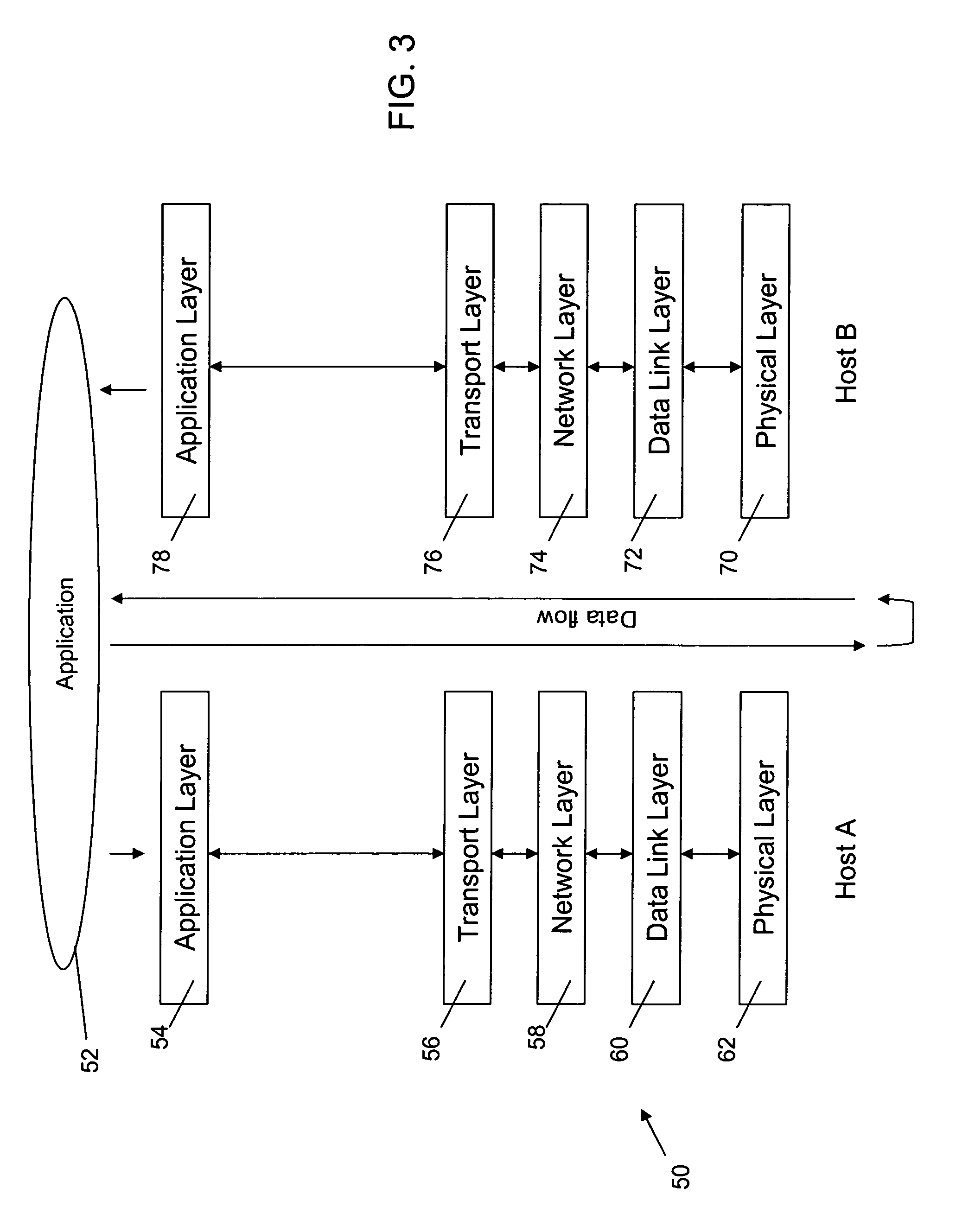
[0017]FIG. 3 shows a protocol stack 50 which can be used in one implementation of the present invention. While five layers are shown therein, it will be appreciated that the present invention can be adapted to implement the seven layer OSI Reference Model addressed above or other models suitably conforming to the requirements of the present invention. As shown in FIG. 3, an application 52 can communicate with stack 50 at the application layer 54 on host A network. The application layer 54 passes the data being communicated to each succeeding lower layer (56, 58, 60) and finally to the physical layer 62. In return on the host B network, data from the remote application is received by the physical layer 70 which in turn passes the data to each succeeding higher layer (72, 74, 76) and finally to the application layer 78 and on to the Application 52.

[0018] When data is received at the application layer 54 from application 52, it is encapsulated between a header and a trailer added by t...


PUM


Abstract

The present invention provides a system and method for geospatially enabling electronic communication protocols. The automatic attachment of additional information to standard communication protocols georeferences the origin and destination of all data passing through the protocols. Georeferenced data transport allows for efficient aggregation from and broadcast to spatial regions and locations through a spatially hierarchical routing network that processes, filters, and redirects data at the lowest level possible. Georeferencing also facilitates location-sensitive data requests and continuously updating situational awareness.

Description

REFERENCE TO RELATED APPLICATIONS [0001] This application claims the benefit pursuant to 35 U.S.C. §119(e) of U.S. provisional patent application Ser. No. 60 / 723,813, filed Oct. 5, 2005 and titled “Method and System for Geospatially Enabling Electronic Communication Protocols,” the disclosure of which is incorporated herein by reference.FIELD OF THE INVENTION [0002] The present invention relates to communication protocols, and more specifically pertains to a method and system for geospatially enabling electronic communication protocols to facilitate, among other things, communications, knowledge and rapid, informed response within a geospatially hierarchical communications network. BACKGROUND OF THE INVENTION [0003] In data communication networks, it is common to employ several protocols arranged in layers. For example, the ISO Open Systems Interconnection (OSI) Reference Model or a portion thereof is frequently employed to deal with communication protocols and network architectures...

Claims


Application Information

Patent Timeline
IPC IPC(8): G06F17/00
CPCH04L45/04H04L45/46H04W40/20H04L67/2819H04L67/18H04L67/28H04L67/327H04L69/32H04L67/564H04L67/56H04L67/63H04L67/52
Inventor DUMAS, MARK E.STOKES, JAMESHILDEBRANDT, WESLEYSURRATT, JASON
Owner SPADAC
Features
  • Generate Ideas
  • Intellectual Property
  • Life Sciences
  • Materials
  • Tech Scout
  • Unparalleled Data Quality
  • Higher Quality Content
  • 60% Fewer Hallucinations
Learn More