System and method for performing 4-dimensional navigation

a navigation system and navigation method technology, applied in the field of navigation and control systems, can solve the problems of wasting fuel, limiting the ability of aircraft to reliably meet the time constraints of air route (waypoint), and no navigation system currently available that displays, so as to achieve reliable prediction and waste fuel

Inactive Publication Date: 2007-05-03
HONEYWELL INT INC
View PDF8 Cites 66 Cited by
  • Summary
  • Abstract
  • Description
  • Claims
  • Application Information

AI Technical Summary

Benefits of technology

[0005] The present invention provides a system and method for computing a vehicle's motion in four dimensions (e.g., three spatial dimensions and time) and reliably predicting the vehicle's arrival time at a predetermined location, by providing a graphical display to an operator of the vehicle's progress that enables the operator to adjust the vehicle's movement and achieve the desired arrival time. In accordance with a preferred embodiment of the present invention, a system and method are provided for computing the movement of an aircraft in four dimensions, predicting its arrival time at a predetermined waypoint, and displaying (in a highly intuitive format) the aircraft's progress in achieving that desired arrival time. The pilot can then adjust the movement (e.g., speed) of the aircraft in accordance with the parameter(s) displayed, in order to achieve the desired arrival time. Thus, for example, numerous aircraft using the present invention could be scheduled to arrive at a specific final approach fix (waypoint) at a predetermined rate (e.g., one aircraft per minute), which would enable the air traffic controllers to optimize runway traffic without having to stack the aircraft in holding patterns and thereby waste fuel. Notably, although an example embodiment of an aircraft navigation and control system and method is described, the present invention can be implemented for any type of vehicle (e.g., aircraft, spacecraft, ship, submarine, bus, train, automobile, etc.) whose operator desires to reach a particular location at a specified time.

Problems solved by technology

Notwithstanding the numerous advantages of the Free Flight program, a significant problem has arisen with respect to the capabilities of existing navigation systems that limit the ability of aircraft to reliably meet the air route (waypoint) time constraints imposed.
However, there is no navigation system currently available that displays an indication to an operator that allows the operator to easily determine whether or not a required waypoint time constraint can be reliably satisfied.
Also, there is no navigation system currently available that provides an interactive indication to an operator of a vehicle's (e.g., aircraft, ship, motor vehicle, etc.) progress in meeting any routing (waypoint) time constraints imposed.

Method used


Image

  • System and method for performing 4-dimensional navigation
  • System and method for performing 4-dimensional navigation
  • System and method for performing 4-dimensional navigation

Examples


Embodiment Construction

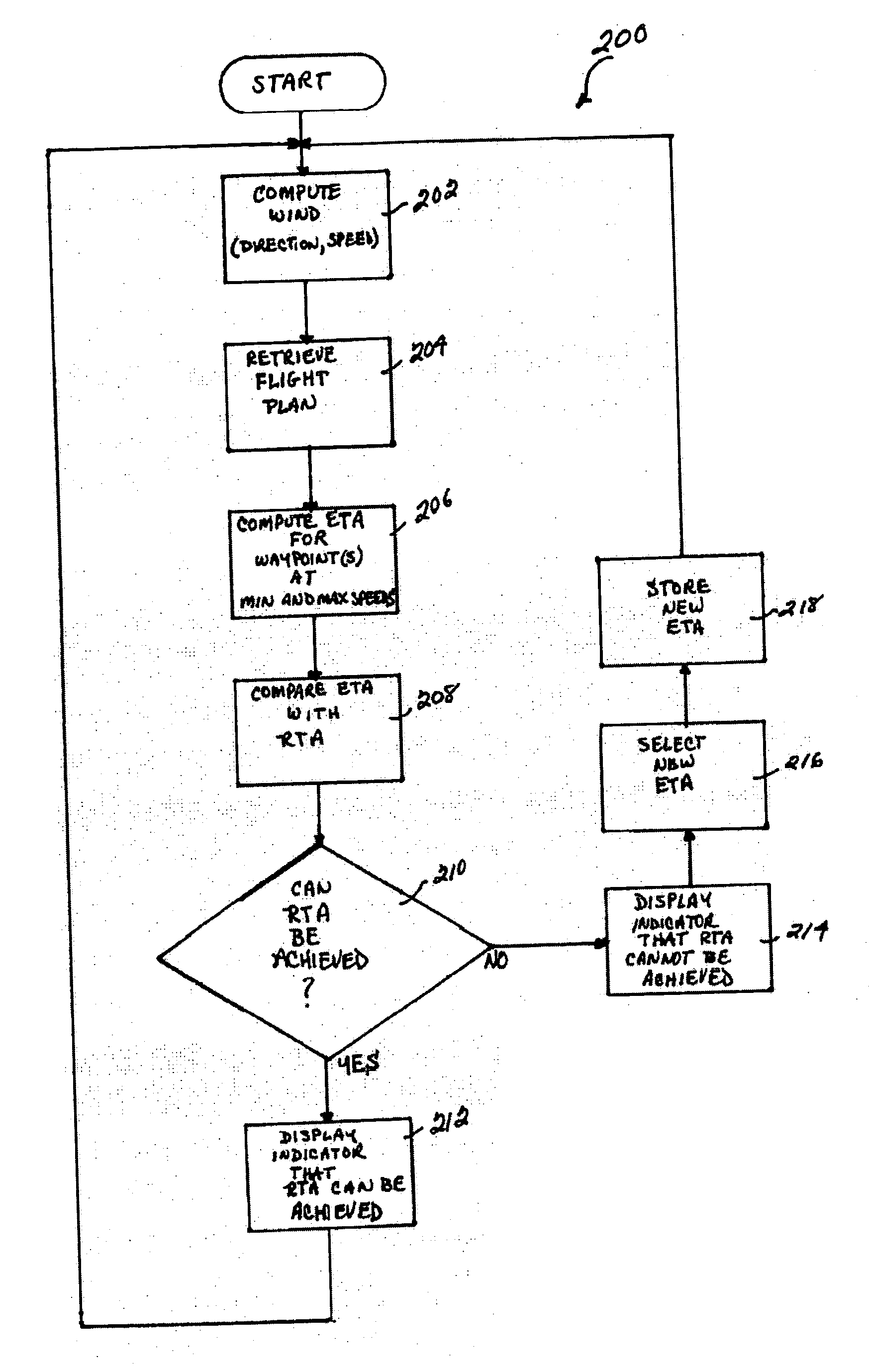
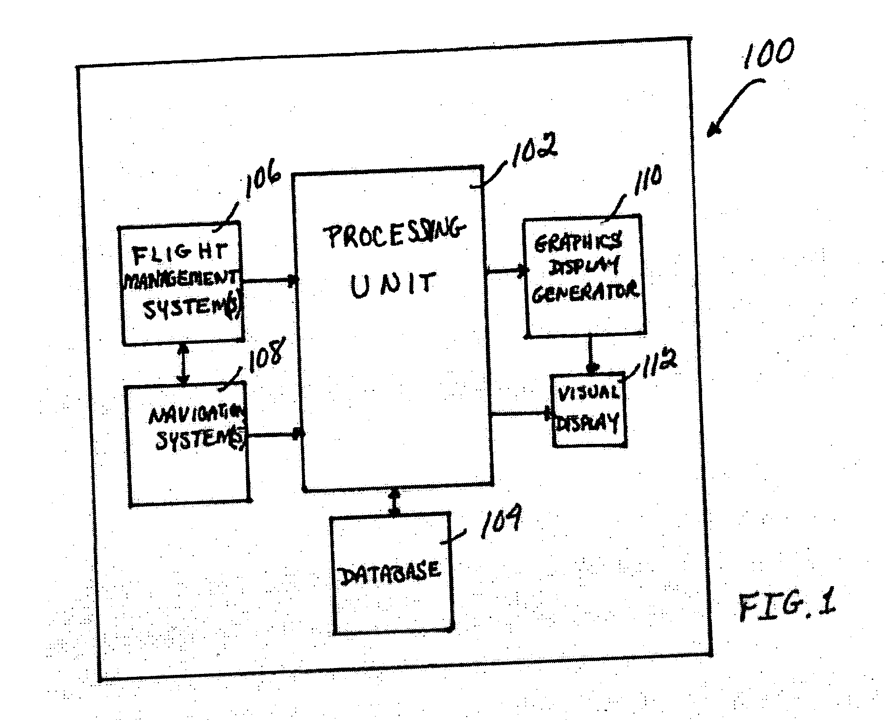
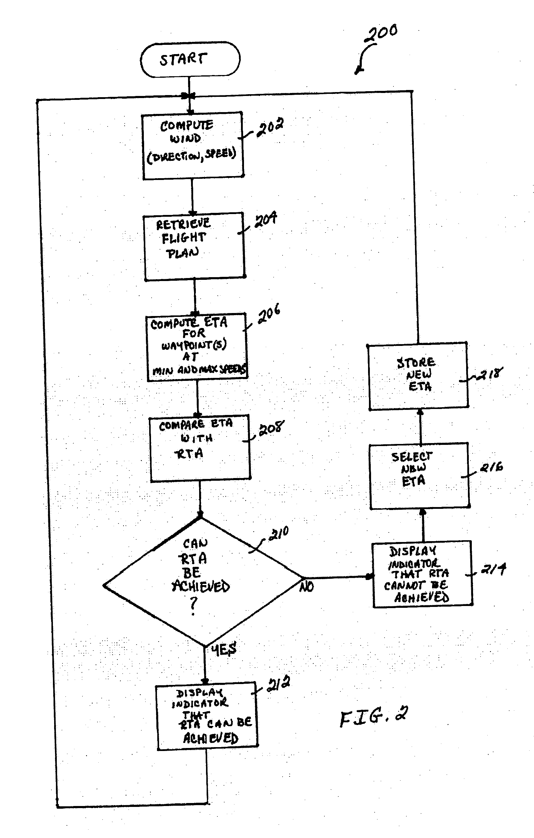
[0010] With reference now to the figures, FIG. 1 depicts a block diagram of an example aircraft navigation and control system 100, which can be used to implement a preferred embodiment of the present invention. Essentially, for this example embodiment, system 100 computes the movement of an aircraft in four dimensions (x, y, z, t), predicts its arrival time at a predetermined waypoint, and displays (in a highly intuitive format) the aircraft's progress in achieving that desired arrival time. The pilot can then adjust the movement (e.g., speed, altitude, track, etc.) of the aircraft in accordance with the parameter(s) displayed, in order to achieve the desired arrival time.

[0011] For this example embodiment, system 100 includes a processing unit 102, a database 104, a flight management system 106, a navigation system 108, a graphics display generator 110, and a visual display 112. Notably, it should be understood that although system 100 appears in FIG. 1 to be arranged as an integr...


PUM


Abstract

A system and method are disclosed for computing a vehicle's motion in four dimensions (e.g., three spatial dimensions and time) and reliably predicting the vehicle's arrival time at a predetermined location, by providing a graphical display to an operator of the vehicle's progress that enables the operator to adjust the vehicle's movement and achieve the desired arrival time. Specifically, a system and method are disclosed for computing the movement of an aircraft in four dimensions, predicting its arrival time at a predetermined waypoint, and displaying (in a highly intuitive format) the aircraft's progress in achieving that desired arrival time. The pilot can then adjust the movement (e.g., speed) of the aircraft in accordance with the parameter(s) displayed, in order to achieve the desired arrival time. Thus, for example, numerous aircraft could be scheduled to arrive at a specific final approach waypoint at a predetermined rate (e.g., one aircraft per minute), which would enable the traffic controllers to optimize runway traffic without having to stack the aircraft in holding patterns and thereby waste fuel. Notably, although an example of an aircraft navigation and control system and method is disclosed, the system and method can be implemented for any type of vehicle (e.g., aircraft, spacecraft, ship, submarine, bus, train, automobile, etc.) whose operator desires to reach a particular location at a specified time.

Description

FIELD OF THE INVENTION [0001] The present invention relates generally to the field of navigation and control systems, and more specifically, but not exclusively, to an improved navigation system and method that provides real-time, 4-dimensional navigation information for operator displays. BACKGROUND OF THE INVENTION [0002] In 1995, the Federal Aviation Administration (FAA) initiated its “Free Flight” air traffic modernization program in order to improve airspace efficiency and capacity, and also revolutionize air traffic control. Essentially, the Free Flight program is designed to provide users (e.g., pilots, flight crews, aircraft operators, airlines, etc.) with as much flight mission flexibility as possible, while also enhancing the safety and predictability of the National Airspace System. Advantageously, the Free Flight program is expected to give aircraft operators increased control over their flight missions, and the opportunity to better control their operating expenses as a...

Claims


Application Information

Patent Timeline
Patent Type & Authority Applications(United States)
IPC IPC(8): G01C21/00
CPCG01C23/00G05D1/101G08G5/0034G05D1/106
Inventor WISE, JOHN A.WILSON, BLAKE W.
Owner HONEYWELL INT INC
Why Eureka
Try Eureka