Image processing system and image processing method for aerial photograph

a technology which is applied in the field of image processing system and image processing method for aerial photographs, can solve the problems of increasing the degree of minuteness of the whole image, affecting the polygonization of the feature, and the inability to detect the accurate shape of the feature, so as to increase the recognition rate of the shadow area and increase the accuracy. the effect of accuracy

Inactive Publication Date: 2007-08-23
HITACHI SOFTWARE ENG
View PDF13 Cites 55 Cited by
  • Summary
  • Abstract
  • Description
  • Claims
  • Application Information

AI Technical Summary

Benefits of technology

[0017]The image processing system for an aerial photograph and the image processing method for an aerial photograph, according to the present invention, can support the more efficient making of more accurate maps by increasing the recognition rate of the shadow area contained in the image of the aerial photograph or the equivalent.
[0018]According to the first aspect of the present invention, the shadow-angle-analyzing means obtains the shadow-produced angle between the direction in which a shadow is extended and a predetermined direction, based on the information on the photographic image and the shadow produced from a feature shown in the photographic image; the shadow analyzing means obtains the shadow-extended ratio, which means the ratio of the length of the shadow to the length of the feature, based on the information on the photographic image, the length of the feature, and the shadow produced from the feature shown in the photographic image; and the shadow-area-extracting means generates the polygon of the shadow area by extracting the shadow area by use of the information on the shadow-produced angle and the shadow-extended ratio from the polygon generated by the polygon-generating means. As a result, the image processing system for an aerial photograph can increase the recognition of the shadow area, and can thereby support the more efficient making of more accurate maps.
[0019]According to the second aspect of the present invention, the shadow-angle-detecting means detects the segments conforming to the shadow-produced angle from among the segments constituting the polygon, which was generated by the polygon-generating means; the shadow-extension-detecting means that judges whether or not

Problems solved by technology

The shadow makes it impossible to detect the accurate shape of the feature to perform the edge extraction, and the shadow interferes with the polygonization of the feature.
However, the method does not eliminate the shadow area from the image, and the method increases the degree of minuteness of the whole image.
However, when taking aerial photographs or satellite images, which do not enable lighting apparatus to be used, the photographing has no choice but to be done with natural solar light.
However, it was not possible to automatically recognize, by mechanizing the system, the area that was not directly shined by solar light (referred to as “shadow area” hereina

Method used


Image

  • Image processing system and image processing method for aerial photograph
  • Image processing system and image processing method for aerial photograph
  • Image processing system and image processing method for aerial photograph

Examples


embodiment 1

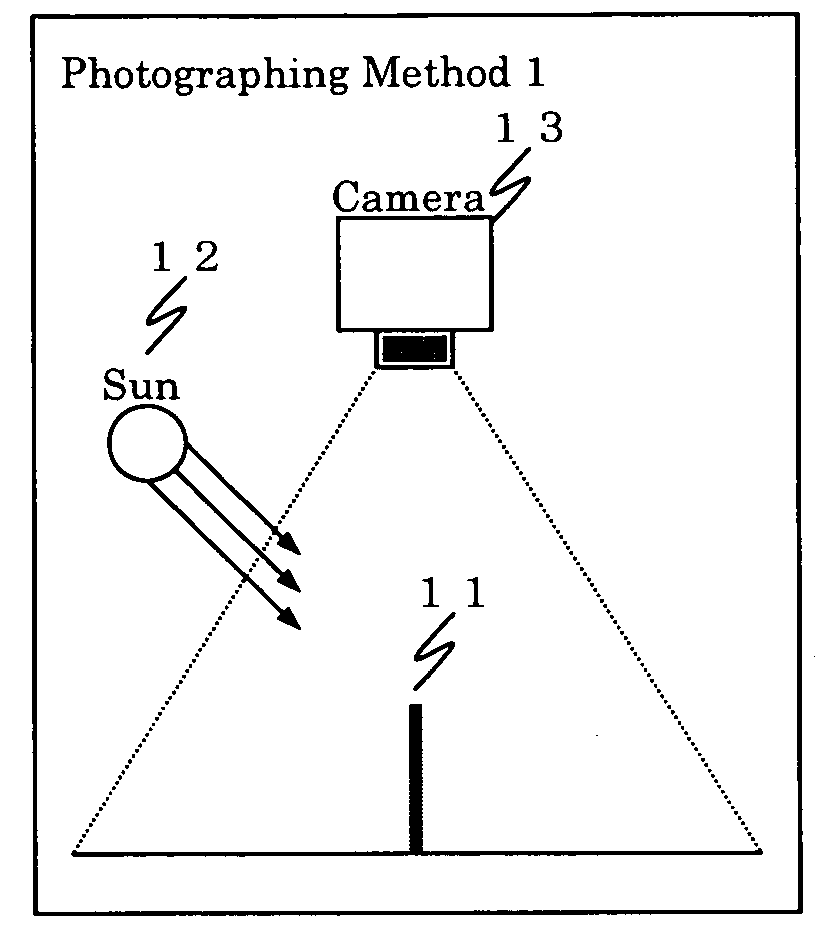
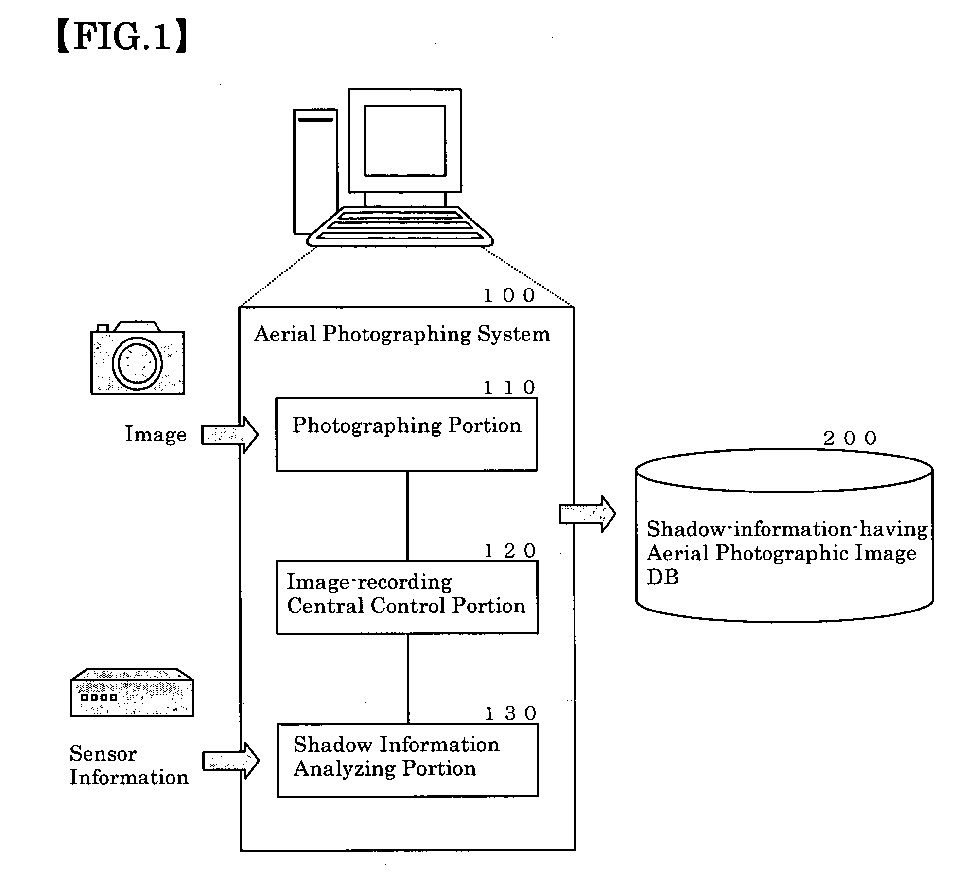
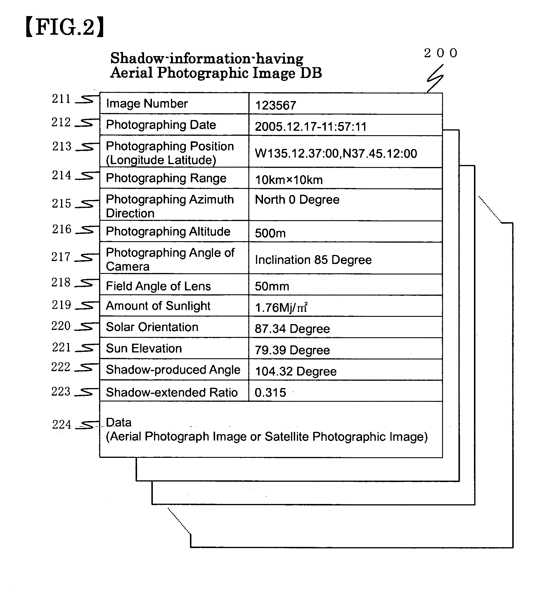
[0033]Embodiment 1 to embody an image processing system for an aerial photograph according to the present invention will now be described as below. The image processing system for an aerial photograph according to this Embodiment includes: an aerial photographing system 100 having the nature-shadow-discriminating-information-collecting function of generating the data used for supporting the generation of the polygons of features by analyzing information on the shadows produced from the features shown in an image, based on information on the image, obtained from images such as aerial photographs or satellite images; and a feature-polygon-generating system 500 that generates the polygons of the features, which contribute to database supporting the making of accurate maps.

[0034]FIG. 1 is an explanatory diagram showing the configuration of the aerial photographing system 100 included in the image processing systems for an aerial photographic image according to Embodiment 1, the aerial p...

embodiment 2

[0069]In Embodiment 1 above described, a judgment was made on whether or not the color tone of the area surrounded by the segments constituting the shadow is darker than that of all the polygons adjacent thereto in step S13; however, the present invention is not so limited. It maybe arranged that a judgment be made about whether or not the color tone of the surrounded area is still darker, and at the same time a judgment be made on whether or not the color of the area surrounded by the segments constituting the shadow is black. Such a process enables a judgment whether or not the area is a shadow area to be more accurately made.


PUM


Abstract

In order to increase the recognition rate of a shadow area contained in the image of an aerial photograph, a central control portion performs the processes of: comparing a shadow-produced angle with the angles of segments constituting the polygons generated by a polygon-generating portion to judge whether or not there are the segments coinciding with the shadow-produced angle, of the segments constituting the polygon; judging whether or not the ratio of the length of the segment constituting the shadow to the length of the segment constituting the feature coincides with a shadow-extended ratio; judging whether or not the color tone of the area surrounded by the segments constituting the shadow is darker than that of all the adjacent polygons; and identifying the area surrounded by the segments constituting the shadow as “shadow area.” The polygon of the identified shadow area is generated.

Description

BACKGROUND OF THE INVENTION[0001]1. Field of the invention[0002]The present invention relates to an image processing system and an image processing method for aerial photographs, which supports map-making by using photographic images such as aerial photographic images and satellite images and analyzing features shown in these photographic images.[0003]2. Description of the Related Art[0004]In recent years, there has been a tendency for the users of digital map data to increase each year because of the proliferations of car navigation devices mounted on motor vehicles and portable terminals (portable telephones particularly) equipped with a GPS function. For this reason, there has been demanded development of map-making systems, which make, at lower cost, digital map data by which the user can get clearer and more detailed data on their present position and destination, and which is more accurate, more up-to-date, and more increased in the volume of information.[0005]Known methods in...

Claims


Application Information

Patent Timeline
IPC IPC(8): G06T15/50G06T1/00G06T11/60G09B29/00
CPCG06T7/0042G06T2207/10032G06T17/05G06T7/0083G06T7/12G06T7/73
Inventor FURUKADO, KAZUHIRO
Owner HITACHI SOFTWARE ENG
Why Eureka
Try Eureka