Ephemeris extension method for GNSS applications

a technology of gnss and ephemeris, applied in satellite radio beaconing, measurement devices, instruments, etc., can solve the problems of gps receivers, difficult to recover gps ephemeris data, and gps navigation messages, etc., to improve the accuracy of receiver positions

Active Publication Date: 2007-10-25
QUALCOMM INC
View PDF42 Cites 57 Cited by
  • Summary
  • Abstract
  • Description
  • Claims
  • Application Information

AI Technical Summary

Benefits of technology

[0012] One embodiment of the invention relates to a method for improving the accuracy of a receiver position, comprising applying a correction to almanac data. Optionally, the method may be so performed that the step of applying a correction to almanac data comprises obtaining a correction term from a prediction file and applying the term to an estimated satellite position. The method may also be performed such that a corrected estimated satellite

Problems solved by technology

After a few hours, the accuracy of this data degrades rapidly, however.
Under low signal power conditions, such as those experienced indoors, it is often very difficult to recover the GPS navigation message and thus to recover GPS ephemeris data.
This means that GPS receivers which have not been allowed a clear view of the sky for several hours will experience a degradation in their position solution accuracy based on inaccurate estimates of each satellite's current position.
Thus, when a vehicle with a PND (Portable Navigation Device) or GPS receiver

Method used


Image

  • Ephemeris extension method for GNSS applications
  • Ephemeris extension method for GNSS applications
  • Ephemeris extension method for GNSS applications

Examples


Embodiment Construction

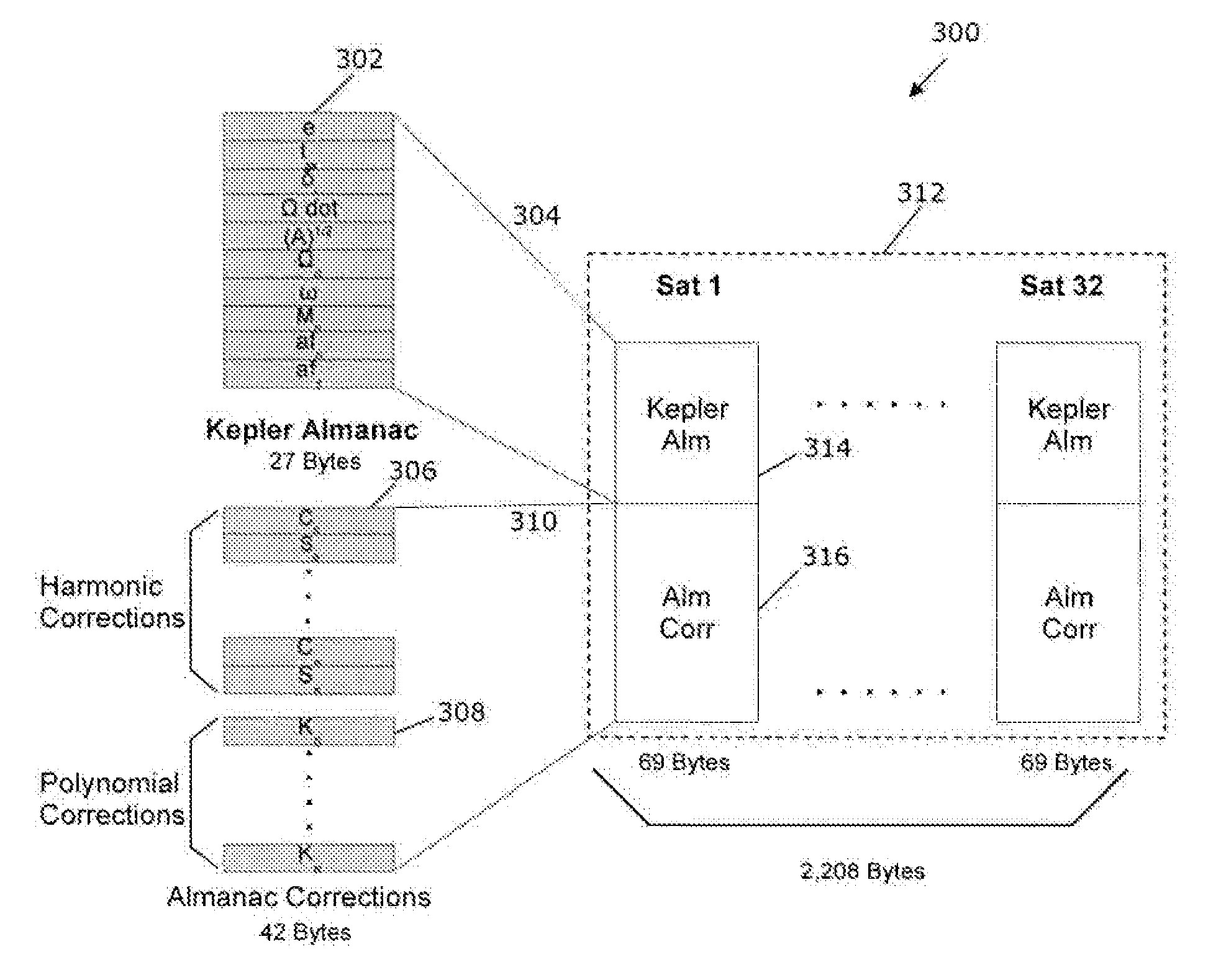
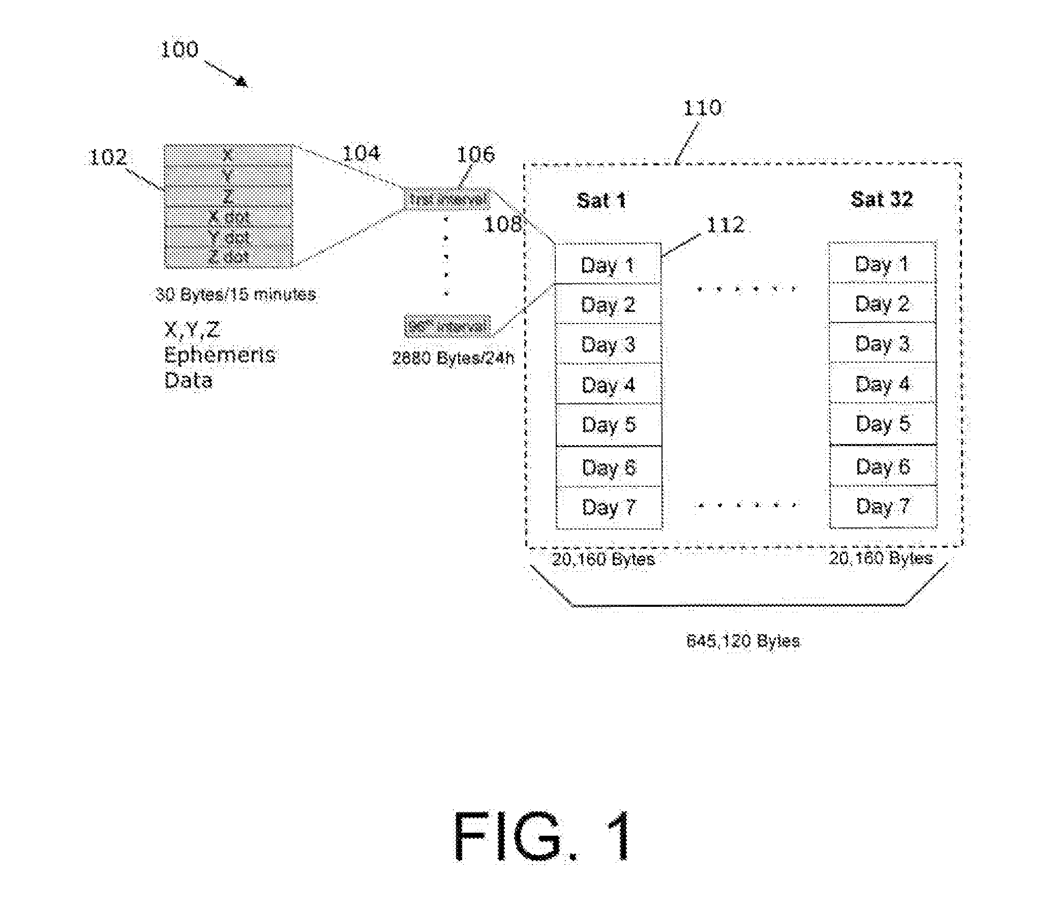
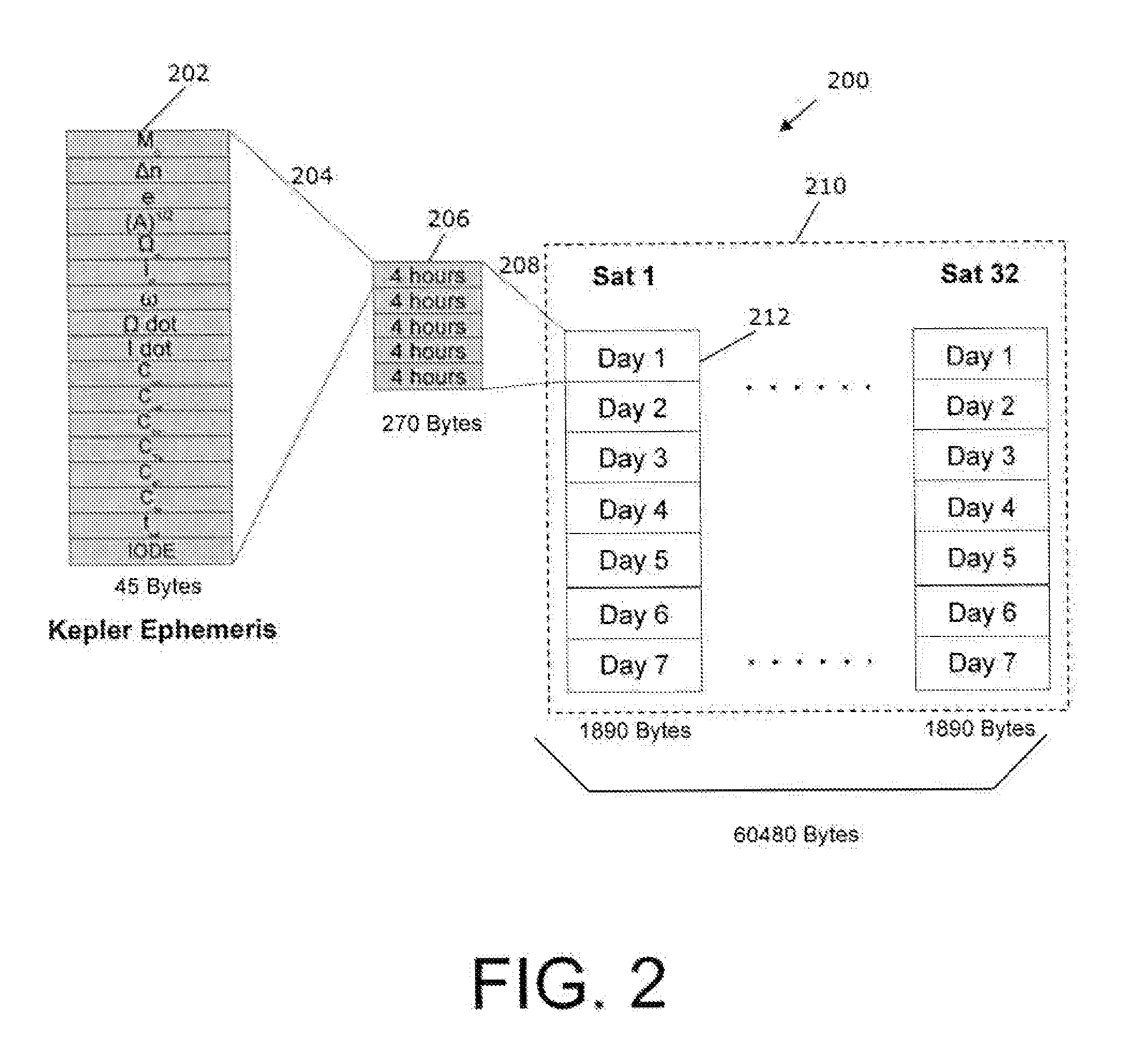
[0020]“Ephemeris Extension” is a technology that allows predicting a set of ephemeris over a period of time much longer than the original 2 hours, typically days. After 4 days the extension over time implies a loss in accuracy with respect to a position calculated from real ephemeris. With a good Ephemeris Extension, the Time To First Fix (TTFF) is always in the 5-15 seconds, in all conditions, which means that there are no more cold or warm starts. The impact is evident in situations where the receiver is switched on after a long period of time (>2 hours) in particular in a difficult environment (e.g., an urban canyon). In weak signal environments fix is still possible without real-time assistance data. Over longer periods, it is not necessary to have real-time assistance, if the user can accept a less accurate fix (after 4 days).

[0021] Referring again to the example of the vehicle leaving the parking garage, embodiments of the present invention would allow a first fix within at m...


PUM


Abstract

Systems, methods and devices for improving the performance of Global Navigation Satellite System (GNSS) receivers are disclosed. In particular, the improvement of the ability to calculate a satellite position or a receiver position where a receiver has degraded ability to receive broadcast ephemeris data directly from a GNSS satellite is disclosed. Correction terms can be applied to an approximate long-term satellite position model such as the broadcast almanac.

Description

CROSS-REFERENCE TO RELATED PATENT APPLICATIONS [0001] This specification is related to and claims the benefit of U.S. Provisional Application No. 60 / 794,102, filed Apr. 24, 2006, which is hereby incorporated by reference. This specification is further related to U.S. Provisional Applications No. 60 / 815,838 filed Jun. 23, 2006 and 60 / 888,232 filed Feb. 5, 2007, both of which are also hereby incorporated by reference.BACKGROUND OF THE INVENTION [0002] The present invention relates generally to the field of Global Navigation Satellite Systems (GNSS) for navigation, such as the Global Positioning System (GPS) or Galileo. [0003] In a GNSS system, satellites in orbit around the Earth broadcast signals that can be received by a receiver equipped to detect them. The signals are transmitted such that a receiver can determine, under adequate signal conditions, the time of transmission of the signal. By receiving four such signals, the receiver can determine the local time and its own position...

Claims


Application Information

Patent Timeline
IPC IPC(8): G01S5/14G01S19/25
CPCG01S19/27G01S19/258
Inventor GARIN, LIONEL
Owner QUALCOMM INC
Why Eureka
Try Eureka